 |
|
McGhee Tyson Airport
McGhee Tyson Air National Guard Base |
| IATA: TYS – ICAO: KTYS – FAA LID: TYS
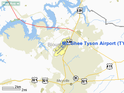
Location of the McGhee Tyson Airport
|
| Summary |
| Airport type |
Public |
| Owner |
Metropolitan Knoxville Airport Authority |
| Serves |
Knoxville, Tennessee |
| Location |
Alcoa, Tennessee |
| Elevation AMSL |
981 ft / 299 m |
| Coordinates |
35°48′40″N 083°59′38″W / 35.81111°N 83.99389°W / 35.81111; -83.99389 |
| Website |
www.TYS.org |
| Runways |
| Direction |
Length |
Surface |
| ft |
m |
| 5L/23R |
9,005 |
2,745 |
Concrete |
| 5R/23L |
9,000 |
2,743 |
Asphalt |
| Statistics (2007) |
| Aircraft operations |
138,682 |
| Based aircraft |
173 |
| Source: Federal Aviation Administration |
Northwest Airlines ticket counter. McGhee Tyson Airport (IATA: TYS, ICAO: KTYS, FAA LID: TYS) is a joint civil-military public airport serving the Knoxville metropolitan area and located approximately 10 miles (16 km) south of the central business district of Knoxville, in Alcoa, Blount County, Tennessee, United States. It is owned by the Metropolitan Knoxville Airport Authority. Commercial service is provided by several major airlines and connection carriers.
The airport is named for United States Navy pilot Charles McGhee Tyson, lost on patrol in World War I.
The airport also serves as the home of McGhee Tyson Air National Guard Base, an air base for the 134th Air Refueling Wing (134 ARW) of the Tennessee Air National Guard. Facilities and aircraft
McGhee Tyson Airport covers an area of 2,250 acres (911 ha) which contains two parallel runways: 5L/23R measuring 9,005 x 150 ft (2,745 x 46 m) and 5R/23L measuring 9,000 x 150 ft (2,743 x 46 m).
The FBO (fixed based operator) general aviation facility is operated by TAC Air (formerly Knoxair and Cherokee Aviation).
For the 12-month period ending December 31, 2007, the airport had 138,682 aircraft operations, an average of 379 per day: 41% general aviation, 40% air taxi, 13% military and 6% scheduled commercial. At that time there were 173 aircraft based at this airport: 39% single-engine, 26% multi-engine, 13% jet, 1% helicopter and 20% military.
Airport terminal layout
McGhee Tyson Airport has two levels. The top level is accessed via the curbside drop off and the parking garage. The top level is used for ticket counters, security, gates, restaurants, and shops. It is designed with a Smoky Mountain theme, complete with faux waterfalls and wood carvings of bears. The bottom level is used for car rental counters, two baggage claims, and airline offices.
Airlines and destinations
| Airlines |
Destinations |
| AirTran Airways |
Orlando |
| Allegiant Air |
Fort Lauderdale, Orlando, St. Petersburg/Clearwater, Punta Gorda-Ft. Myers, Myrtle Beach |
| American Eagle |
Chicago-O'Hare, Dallas/Fort Worth, Miami |
| Continental Express operated by ExpressJet Airlines |
Cleveland, Houston-Intercontinental, Newark |
| Delta Air Lines |
Atlanta |
| Delta Connection operated by Atlantic Southeast Airlines |
Atlanta |
| Delta Connection operated by Chautauqua Airlines |
Cincinnati/Northern Kentucky |
| Delta Connection operated by Comair |
Atlanta, Cincinnati/Northern Kentucky |
| Delta Connection operated by Pinnacle Airlines |
Atlanta, Detroit, Memphis, Minneapolis/St. Paul, New York-LaGuardia |
| Delta Connection operated by Shuttle America |
Atlanta |
| United Express operated by ExpressJet Airlines |
Chicago-O'Hare |
| United Express operated by Mesa Airlines |
Chicago-O'Hare |
| United Express operated by SkyWest Airlines |
Chicago-O'Hare, Denver |
| United Express operated by Trans States Airlines |
Chicago-O'Hare, Washington-Dulles |
| US Airways Express operated by Mesa Airlines |
Charlotte |
| US Airways Express operated by Piedmont Airlines |
Charlotte |
| US Airways Express operated by PSA Airlines |
Charlotte, Philadelphia, Washington-Reagan |
Cargo
- Federal Express
- United Parcel Service
Air National Guard BaseThe 134 ARW, which is operationally gained by the Air Mobility Command (AMC), operates KC-135R Stratotankers for both air mobility and aerial refueling of military aircraft. McGhee Tyson ANGB is also home to the I.G. Brown Air National Guard Training and Education Center and its associated Academy of Military Science (AMS). Similar to U.S. Air Force (USAF) Officer Training School (OTS), AMS is an alternate commissioning source for USAF officers who are directly inputted into various units of the Air National Guard throughout the United States.
The above content comes from Wikipedia and is published under free licenses – click here to read more.
Location & QuickFacts
| FAA Information Effective: | 2008-09-25 |
| Airport Identifier: | TYS |
| Airport Status: | Operational |
| Longitude/Latitude: | 083-59-38.5000W/35-48-39.5000N
-83.994028/35.810972 (Estimated) |
| Elevation: | 981 ft / 299.01 m (Surveyed) |
| Land: | 2250 acres |
| From nearest city: | 10 nautical miles S of Knoxville, TN |
| Location: | Blount County, TN |
| Magnetic Variation: | 03W (1985) |
Owner & Manager
| Ownership: | Publicly owned |
| Owner: | Metro Knoxville Arpt Auth |
| Address: | Mc Ghee Tyson Airport
Alcoa, TN 37701 |
| Phone number: | 865-342-3000 |
| Manager: | Trevis Gardner |
| Address: | Po Box 15600
Knoxville, TN 37901 |
| Phone number: | 865-342-3088 |
Airport Operations and Facilities
| Airport Use: | Open to public |
| Wind indicator: | Yes |
| Segmented Circle: | Yes |
| Control Tower: | Yes |
| Lighting Schedule: | DUSK-DAWN |
| Beacon Color: | Clear-Green (lighted land airport) |
| Landing fee charge: | No |
| Sectional chart: | Atlanta |
| Region: | ASO - Southern |
| Boundary ARTCC: | ZTL - Atlanta |
| Tie-in FSS: | BNA - Nashville |
| FSS on Airport: | No |
| FSS Toll Free: | 1-800-WX-BRIEF |
| NOTAMs Facility: | TYS (NOTAM-d service avaliable) |
| Certification type/date: | I C S 05/1973 |
| Federal Agreements: | NGPY3 |
Airport Communications
Airport Services
| Fuel available: | 100LLA
J8 (MIL) ALSO AVBL. |
| Airframe Repair: | MAJOR |
| Power Plant Repair: | MAJOR |
| Bottled Oxygen: | NONE |
| Bulk Oxygen: | HIGH |
Runway Information
Runway 05L/23R
| Dimension: | 9005 x 150 ft / 2744.7 x 45.7 m |
| Surface: | CONC, Good Condition |
| Surface Treatment: | Saw-cut or plastic Grooved |
| Weight Limit: | Single wheel: 90000 lbs.
Dual wheel: 200000 lbs.
Dual tandem wheel: 350000 lbs.
Dual dual tandem wheel: 540000 lbs. |
| Edge Lights: | High |
| |
Runway 05L |
Runway 23R |
| Longitude: | 084-00-19.6773W | 083-59-02.6161W |
| Latitude: | 35-48-15.5883N | 35-49-18.7544N |
| Elevation: | 923.00 ft | 976.00 ft |
| Alignment: | 45 | 127 |
| ILS Type: | ILS
| ILS
|
| Traffic Pattern: | Left | Right |
| Markings: | Precision instrument, Good Condition | Precision instrument, Good Condition |
| Crossing Height: | 75.00 ft | 56.00 ft |
| VASI: | 4-box on left side | 4-box on left side |
| Visual Glide Angle: | 2.70° | 3.00° |
| RVR Equipment: | touchdown, midfield, rollout | touchdown, midfield, rollout |
| Approach lights: | MALSR | ALSF2 |
| Centerline Lights: | Yes | Yes |
| Touchdown Lights: | No | Yes |
|
Runway 05R/23L
| Dimension: | 9000 x 150 ft / 2743.2 x 45.7 m |
| Surface: | ASPH, Good Condition |
| Surface Treatment: | Saw-cut or plastic Grooved |
| Weight Limit: | Single wheel: 75000 lbs.
Dual wheel: 200000 lbs.
Dual tandem wheel: 270000 lbs. |
| Edge Lights: | High |
| |
Runway 05R |
Runway 23L |
| Longitude: | 084-00-14.4126W | 083-58-57.4060W |
| Latitude: | 35-48-00.2533N | 35-49-03.3925N |
| Elevation: | 938.00 ft | 962.00 ft |
| Alignment: | 45 | 127 |
| Traffic Pattern: | Right | Left |
| Markings: | Precision instrument, Good Condition | Precision instrument, Good Condition |
| Crossing Height: | 43.00 ft | 55.00 ft |
| Displaced threshold: | 0.00 ft | 400.00 ft |
| VASI: | 4-light PAPI on left side | 4-light PAPI on left side |
| Visual Glide Angle: | 3.00° | 3.00° |
| RVR Equipment: | | touchdown |
| Runway End Identifier: | Yes | Yes |
| Centerline Lights: | Yes | Yes |
| Touchdown Lights: | Yes | |
| Obstruction: | , 50:1 slope to clear | 43 ft tree, 1975.0 ft from runway, 175 ft left of centerline, 41:1 slope to clear |
| Decleard distances: | Take off run available 9000.00 ft
Take off distance available 9000.00 ft
Actual stop distance available 8600.00 ft
Landing distance available 8600.00 ft
| Take off run available 9000.00 ft
Take off distance available 9000.00 ft
Actual stop distance available 9000.00 ft
Landing distance available 8600.00 ft
|
|
Radio Navigation Aids
| ID |
Type |
Name |
Ch |
Freq |
Var |
Dist |
| MNV | NDB | Madisonville | | 361.00 | 04W | 24.8 nm |
| JXT | NDB | Jefferson | | 346.00 | 04W | 31.0 nm |
| JAU | NDB | Jacksboro | | 204.00 | 03W | 32.7 nm |
| MMI | NDB | Mc Minn County | | 242.00 | 03W | 37.4 nm |
| TTQ | NDB | Tomotla | | 335.00 | 01W | 41.8 nm |
| BPO | NDB | Piney Grove | | 403.00 | 05W | 49.6 nm |
| DTE | NDB | Mark Anton | | 394.00 | 02W | 49.9 nm |
| VXV | VORTAC | Volunteer | 111X | 116.40 | 03W | 7.4 nm |
| SOT | VORTAC | Snowbird | 025X | 108.80 | 04W | 45.9 nm |
| HCH | VORTAC | Hinch Mountain | 123X | 117.60 | 02W | 48.0 nm |
| TYS | VOT | Knoxville | | 112.00 | | 0.1 nm |
Remarks
- WIDE-BODIED ACFT USE CARE WHEN TURNING ONTO TWY A FROM RAMPS 4, 5 & 6.
- HOLD SHORT LINE FOR RY 23L LCTD SLIGHTLY NORTH OF TWY A-8.
- RSTD: TWY G1/RWY 5L UNDERRUN USBLWITH PRIOR COORDINATION ONLY. TWY G5 AND G6 ARE UNUSBL FOR MIL ACFT.
- CAUTION: USE CTN RWY 23L HOLDSHORT LN IS IMT PAST TWY A8. PTN OF TWY A NEAR RWY 5R APCH END NOT VSB FM TWR.
- REMARKS: CTC SODA CTL FOR CURRENT BIRD WATCH COND.
- ARMY NG BASE OPS OPERS 0730-1700 MON-FRI. PPR DSN 266-4601/4605.
- CAUTION: BIRDS ON & IN VICINITY OF ARPT, INCREASED OCT-APR.
- PPR FROM ANG FOR CIVIL ACFT TO USE TWYS G1; G2; G3; G4; & G SOUTH OF TWY G5. CONTACT 865-985-4371
- MAINTAIN RY HEADING UNTIL PASSING RESIDENTIAL AREA SOUTH OF EXTDD RY CNTRLN UNLESS OTHERWISE INSTRUCTED BY ATC.
Images and information placed above are from
http://www.airport-data.com/airport/TYS/
We thank them for the data!
| General Info
|
| Country |
United States
|
| State |
TENNESSEE
|
| FAA ID |
TYS
|
| Latitude |
35-48-44.954N
|
| Longitude |
083-59-34.281W
|
| Elevation |
981 feet
|
| Near City |
KNOXVILLE
|
We don't guarantee the information is fresh and accurate. The data may
be wrong or outdated.
For more up-to-date information please refer to other sources.
|
|


