 |
|
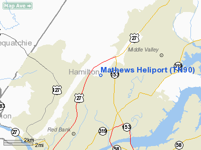
Location & QuickFacts
| FAA Information Effective: | 2008-09-25 |
| Airport Identifier: | TN90 |
| Airport Status: | Operational |
| Longitude/Latitude: | 085-15-54.0000W/35-10-10.0000N
-85.265000/35.169444 (Estimated) |
| Elevation: | 710 ft / 216.41 m (Estimated) |
| Land: | 0 acres |
| From nearest city: | 7 nautical miles NE of Chattanooga, TN |
| Location: | Hamilton County, TN |
| Magnetic Variation: | 03W (2000) |
Owner & Manager
| Ownership: | Privately owned |
| Owner: | David Mathews |
| Address: | 6044 Browntown Road
Chattanooga, TN 37415 |
| Phone number: | 423-877-6191 |
| Manager: | David Mathews |
| Address: | 6044 Browntown Road
Chattanooga, TN 37415 |
| Phone number: | 423-877-6191 |
Airport Operations and Facilities
| Airport Use: | Private |
| Wind indicator: | Yes |
| Segmented Circle: | No |
| Control Tower: | No |
| Sectional chart: | Atlanta |
| Region: | ASO - Southern |
| Boundary ARTCC: | ZTL - Atlanta |
| Tie-in FSS: | BNA - Nashville |
| FSS Toll Free: | 1-800-WX-BRIEF |
Runway Information
Helipad H1
| Dimension: | 100 x 50 ft / 30.5 x 15.2 m |
| Surface: | TURF, |
| |
Runway H1 |
Runway |
| Traffic Pattern: | Left | Left |
|
Radio Navigation Aids
| ID |
Type |
Name |
Ch |
Freq |
Var |
Dist |
| CQN | NDB | Daisy | | 341.00 | 02W | 5.3 nm |
| APT | NDB | Jasper | | 382.00 | 02W | 17.0 nm |
| HDI | NDB | Hardwick | | 369.00 | 01W | 17.7 nm |
| DTE | NDB | Mark Anton | | 394.00 | 02W | 24.9 nm |
| UWI | NDB | Whitfield | | 400.00 | 03W | 27.7 nm |
| UOS | NDB | Sewanee | | 275.00 | 02E | 31.1 nm |
| MMI | NDB | Mc Minn County | | 242.00 | 03W | 37.1 nm |
| BGF | NDB | Boiling Fork | | 263.00 | 02W | 39.5 nm |
| RN | NDB | Warri | | 209.00 | 02W | 42.7 nm |
| FTP | NDB | Fort Payne | | 426.00 | 01W | 43.9 nm |
| MNV | NDB | Madisonville | | 361.00 | 04W | 48.8 nm |
| OUK | NDB | Calhoun | | 323.00 | 02W | 49.1 nm |
| UXM | VOR | Tullahoma Regional | | 109.65 | 03W | 49.8 nm |
| GQO | VORTAC | Choo Choo | 105X | 115.80 | 01E | 13.7 nm |
| HCH | VORTAC | Hinch Mountain | 123X | 117.60 | 02W | 39.3 nm |
Remarks
- 45 FT POWER LINE 100 FT EAST OF HELIPAD.
- PRVDD AREA IS MKD, INGRESS FROM 035 TO 060 DEGS & EGRESS FROM 215 TO 230 DEGS, WIND INDICATOR MAINTAINED, NO NIGHT OPNS UNLESS WIND INDICATOR IS LGTD & ROTG BCN IS INSTALLED.
Images and information placed above are from
http://www.airport-data.com/airport/TN90/
We thank them for the data!
| General Info
|
| Country |
United States
|
| State |
TENNESSEE
|
| FAA ID |
TN90
|
| Latitude |
35-10-10.000N
|
| Longitude |
085-15-54.000W
|
| Elevation |
710 feet
|
| Near City |
CHATTANOOGA
|
We don't guarantee the information is fresh and accurate. The data may
be wrong or outdated.
For more up-to-date information please refer to other sources.
|
|


