 |
|
Coordinates: 36°24′44″N 085°18′42″W / 36.41222°N 85.31167°W / 36.41222; -85.31167
| Livingston Municipal Airport |
| IATA: none – ICAO: none – FAA LID: 8A3 |
| Summary |
| Airport type |
Public |
| Owner |
City of Livingston |
| Serves |
Livingston, Tennessee |
| Elevation AMSL |
1,372 ft / 418 m |
| Runways |
| Direction |
Length |
Surface |
| ft |
m |
| 3/21 |
3,998 |
1,219 |
Asphalt |
| Statistics (1999) |
| Aircraft operations |
10,570 |
| Based aircraft |
14 |
| Source: Federal Aviation Administration |
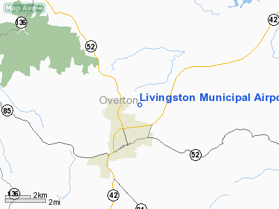
Livingston Municipal Airport (FAA LID: 8A3) is a city-owned public-use airport located two miles (3 km) northeast of the central business district of Livingston, a city in Overton County, Tennessee, United States.
Facilities and aircraft
Livingston Municipal Airport covers an area of 44 acres (18 ha) and contains one runway designated 3/21 which measures 3,998 x 75 ft (1,219 x 23 m). For the 12-month period ending February 26, 1999, the airport had 10,570 aircraft operations, an average of 28 per day: 99.6% general aviation and 0.4% military. At that time there were 14 aircraft based at this airport: 93% single-engine and 7% multi-engine.
The above content comes from Wikipedia and is published under free licenses – click here to read more.
Location & QuickFacts
| FAA Information Effective: | 2008-09-25 |
| Airport Identifier: | 8A3 |
| Airport Status: | Operational |
| Longitude/Latitude: | 085-18-41.6630W/36-24-43.6320N
-85.311573/36.412120 (Estimated) |
| Elevation: | 1372 ft / 418.19 m (Surveyed) |
| Land: | 122 acres |
| From nearest city: | 2 nautical miles NE of Livingston, TN |
| Location: | Overton County, TN |
| Magnetic Variation: | 02W (1985) |
Owner & Manager
| Ownership: | Publicly owned |
| Owner: | City Of Livingston |
| Address: | City Hall
Livingston, TN 38570 |
| Phone number: | 931-823-1269
AMGR CELL: 931-239-0070 |
| Manager: | Greg Booher |
| Address: | 632 Airport Rd
Livingston, TN 38570 |
| Phone number: | 931-823-1158 |
Airport Operations and Facilities
| Airport Use: | Open to public |
| Wind indicator: | Yes |
| Segmented Circle: | No |
| Control Tower: | No |
| Lighting Schedule: | DUSK-DAWN |
| Beacon Color: | Clear-Green (lighted land airport) |
| Landing fee charge: | No |
| Sectional chart: | St Louis |
| Region: | ASO - Southern |
| Boundary ARTCC: | ZID - Indianapolis |
| Tie-in FSS: | BNA - Nashville |
| FSS on Airport: | No |
| FSS Toll Free: | 1-800-WX-BRIEF |
| NOTAMs Facility: | BNA (NOTAM-d service avaliable) |
| Federal Agreements: | N |
Airport Communications
| CTAF: | 122.800 |
| Unicom: | 122.800 |
Airport Services
| Fuel available: | 100LLA1 |
| Airframe Repair: | MINOR |
| Power Plant Repair: | MINOR |
| Bottled Oxygen: | NONE |
| Bulk Oxygen: | NONE |
Runway Information
Runway 03/21
| Dimension: | 3998 x 75 ft / 1218.6 x 22.9 m |
| Surface: | ASPH, Good Condition |
| Weight Limit: | Single wheel: 14000 lbs.
Dual wheel: 21000 lbs. |
| Edge Lights: | Medium |
| |
Runway 03 |
Runway 21 |
| Longitude: | 085-18-55.0100W | 085-18-28.0700W |
| Latitude: | 36-24-27.3600N | 36-25-00.3600N |
| Elevation: | 1366.00 ft | 1372.00 ft |
| Alignment: | 33 | 127 |
| Traffic Pattern: | Left | Left |
| Markings: | Basic, Good Condition | Basic, Good Condition |
| Crossing Height: | 0.00 ft | 21.00 ft |
| VASI: | 2-box on left side | 2-box SAVASI on left side |
| Visual Glide Angle: | 0.00° | 4.00° |
| Runway End Identifier: | Yes | Yes |
| Obstruction: | 24 ft trees, 246.0 ft from runway, 72 ft left of centerline, 2:1 slope to clear | 23 ft trees, 1119.0 ft from runway, 22 ft left of centerline, 39:1 slope to clear |
|
Radio Navigation Aids
| ID |
Type |
Name |
Ch |
Freq |
Var |
Dist |
| HEM | NDB | Huchn | | 233.00 | 02W | 28.8 nm |
| EKQ | NDB | Elk Spring | | 290.00 | 03W | 34.7 nm |
| SKN | NDB | Hurricane | | 256.00 | 02W | 35.2 nm |
| LFB | NDB | Lafayette | | 245.00 | 02W | 36.8 nm |
| BPO | NDB | Piney Grove | | 403.00 | 05W | 41.1 nm |
| RN | NDB | Warri | | 209.00 | 02W | 45.3 nm |
| CDX | NDB | Cumberland River | | 388.00 | 05E | 46.4 nm |
| BVQ | NDB | Beaver Creek | | 260.00 | 02W | 49.5 nm |
| LVT | VORTAC | Livingston | 021X | 108.40 | 02W | 12.5 nm |
| HCH | VORTAC | Hinch Mountain | 123X | 117.60 | 02W | 41.2 nm |
Images and information placed above are from
http://www.airport-data.com/airport/8A3/
We thank them for the data!
| General Info
|
| Country |
United States
|
| State |
TENNESSEE
|
| FAA ID |
8A3
|
| Latitude |
36-24-43.632N
|
| Longitude |
085-18-41.663W
|
| Elevation |
1372 feet
|
| Near City |
LIVINGSTON
|
We don't guarantee the information is fresh and accurate. The data may
be wrong or outdated.
For more up-to-date information please refer to other sources.
|
|


