 |
|
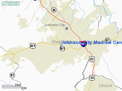
Johnson City Medical Center Heliport |
Location & QuickFacts
| FAA Information Effective: | 2008-09-25 |
| Airport Identifier: | TN91 |
| Airport Status: | Operational |
| Longitude/Latitude: | 082-23-08.0000W/36-18-30.0000N
-82.385556/36.308333 (Estimated) |
| Elevation: | 1745 ft / 531.88 m (Estimated) |
| Land: | 0 acres |
| From nearest city: | 3 nautical miles W of Johnson City, TN |
| Location: | Washington County, TN |
| Magnetic Variation: | 04W (1985) |
Owner & Manager
| Ownership: | Publicly owned |
| Owner: | Johnson City Medical Ctr Hosp |
| Address: | 400 State Of Franklin Road
Johnson City, TN 37601 |
| Phone number: | 423-431-5863 |
| Manager: | Jason L. Hefner |
| Address: | 400 State Of Franklin Road
Johnson City, TN 37601 |
| Phone number: | 423-431-5863 |
Airport Operations and Facilities
| Airport Use: | Private
MEDICAL. |
| Wind indicator: | Yes |
| Segmented Circle: | No |
| Control Tower: | No |
| Lighting Schedule: | DUSK-DAWN |
| Sectional chart: | Atlanta |
| Region: | ASO - Southern |
| Boundary ARTCC: | ZTL - Atlanta |
| Tie-in FSS: | BNA - Nashville |
| FSS Toll Free: | 1-800-WX-BRIEF |
Runway Information
Helipad H1
| Dimension: | 40 x 40 ft / 12.2 x 12.2 m |
| Surface: | CONC, |
| |
Runway H1 |
Runway |
| Traffic Pattern: | Left | Left |
|
Radio Navigation Aids
| ID |
Type |
Name |
Ch |
Freq |
Var |
Dist |
| MRN | FAN MARKER | Lenoir | | | 03W | 48.1 nm |
| EZT | NDB | Elizabethton | | 275.00 | 02W | 5.6 nm |
| BO | NDB | Booie | | 221.00 | 04W | 7.6 nm |
| RVN | NDB | Rogersville | | 329.00 | 04W | 25.7 nm |
| BAR | NDB | Hemlock | | 320.00 | 02W | 26.2 nm |
| DYQ | NDB | Dulaney | | 263.00 | 04W | 26.6 nm |
| JJO | NDB | Mountain City | | 396.00 | 04W | 27.9 nm |
| VJ | NDB | Whine | | 236.00 | 05W | 33.1 nm |
| LQV | NDB | Long Hollow | | 252.00 | 03W | 41.0 nm |
| FIQ | NDB | Fiddlers | | 391.00 | 07W | 50.0 nm |
| GZG | VOR/DME | Glade Spring | 039X | 110.20 | 02W | 34.4 nm |
| HMV | VORTAC | Holston Mountain | 093X | 114.60 | 04W | 14.6 nm |
| SOT | VORTAC | Snowbird | 025X | 108.80 | 04W | 44.9 nm |
Remarks
- PRVDD VFR/PVT USE; APCH/DEP FM 180 TO 360 CLOCKWISE; AREA IS MARKED; WIND INDICATOR IS MAINTAINED; LIGHT POLE WEST OF PAD BE MARKED OR REMOVED.
Images and information placed above are from
http://www.airport-data.com/airport/TN91/
We thank them for the data!
| General Info
|
| Country |
United States
|
| State |
TENNESSEE
|
| FAA ID |
TN91
|
| Latitude |
36-18-30.000N
|
| Longitude |
082-23-08.000W
|
| Elevation |
1745 feet
|
| Near City |
JOHNSON CITY
|
We don't guarantee the information is fresh and accurate. The data may
be wrong or outdated.
For more up-to-date information please refer to other sources.
|
|


