 |
|
| John C. Tune Airport |
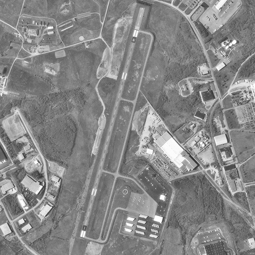 |
| USGS aerial image, 2 April 1998 |
| IATA: none – ICAO: KJWN – FAA LID: JWN |
| Summary |
| Airport type |
Public |
| Owner |
Metropolitan Nashville Airport Authority |
| Serves |
Nashville, Tennessee |
| Elevation AMSL |
495 ft / 151 m |
| Coordinates |
36°10′56″N 086°53′12″W / 36.18222°N 86.88667°W / 36.18222; -86.88667 |
| Runways |
| Direction |
Length |
Surface |
| ft |
m |
| 2/20 |
5,500 |
1,676 |
Asphalt |
| Statistics (2009) |
| Aircraft operations |
72,998 |
| Based aircraft |
165 |
| Source: Federal Aviation Administration |
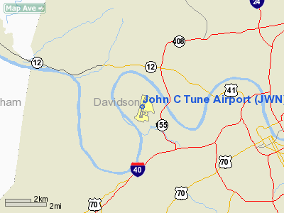
John C. Tune Airport (ICAO: KJWN, FAA LID: JWN) is a public airport located in the western portion of the city of Nashville in Davidson County, Tennessee, United States. It is owned by the Metropolitan Nashville Airport Authority, located approximately one mile (1.6 km) off of Briley Parkway. It is a Class E airport.
Although most U.S. airports use the same three-letter location identifier for the FAA and IATA, this airport is assigned JWN by the FAA but has no designation from the IATA. History
Tune Airport, named in honor of a former chairman of the Airport Authority, was planned in the 1970s and built in the early 1980s as a "reliever airport" designed to divert almost all general aviation from Nashville International Airport (Berry Field), leaving the larger facility for flights on scheduled airlines and its service as an Air National Guard base. However, many general aviation users were reluctant to leave BNA and its well-developed infrastructure. Tune Airport was underutilized for years until increasing fees at BNA drove a considerable number of users to Tune in recent years.
Facilities and aircraft
John C. Tune Airport covers an area of 390 acres (158 ha) at an elevation of 495 feet (151 m) above mean sea level. It has one asphalt paved runway designed 2/20 which measures 5,500 by 100 feet (1,676 x 30 m). The runway is long enough to serve small jets such as Lear Jets.
For the 12-month period ending March 6, 2009, the airport had 72,998 aircraft operations, an average of 199 per day: 70% general aviation, 29% air taxi and <1% military. At that time there were 165 aircraft based at this airport: 79% single-engine, 16% multi-engine, 3% jet and 2% helicopter.
The above content comes from Wikipedia and is published under free licenses – click here to read more.
Location & QuickFacts
| FAA Information Effective: | 2008-09-25 |
| Airport Identifier: | JWN |
| Airport Status: | Operational |
| Longitude/Latitude: | 086-53-12.2000W/36-10-56.5000N
-86.886722/36.182361 (Estimated) |
| Elevation: | 495 ft / 150.88 m (Surveyed) |
| Land: | 390 acres |
| From nearest city: | 1 nautical miles NW of Nashville, TN |
| Location: | Davidson County, TN |
| Magnetic Variation: | 01W (1990) |
Owner & Manager
| Ownership: | Publicly owned |
| Owner: | Metro Nashville Apt Authority |
| Address: | One Terminal Dr.
Nashville, TN 37214 |
| Phone number: | 615-275-1664 |
| Manager: | Kathy Hatter |
| Address: | One Terminal Dr.
Nashville, TN 37214
AIRPORT PHYSICAL ADDRESS IS 110 TUNE AIRPORT DRIVE, NASHVILLE, TN 37209 |
| Phone number: | 615-350-6551 |
Airport Operations and Facilities
| Airport Use: | Open to public |
| Wind indicator: | Yes |
| Segmented Circle: | Yes |
| Control Tower: | No |
| Lighting Schedule: | DUSK-DAWN
MIRL RY 02/20 PRESET LOW INTST SS-SR; TO INCR INTST & ACTVT SR-SS - CTAF. ACTVT REIL RY 02 & 20 AND TWY LGTS - CTAF. |
| Beacon Color: | Clear-Green (lighted land airport) |
| Sectional chart: | St Louis |
| Region: | ASO - Southern |
| Traffic Pattern Alt: | 1000 ft |
| Boundary ARTCC: | ZME - Memphis |
| Tie-in FSS: | BNA - Nashville |
| FSS Toll Free: | 1-800-WX-BRIEF |
| NOTAMs Facility: | BNA (NOTAM-d service avaliable) |
| Federal Agreements: | NGY |
Airport Communications
| CTAF: | 122.700 |
| Unicom: | 122.700 |
Airport Services
| Fuel available: | 100LLA+ |
| Airframe Repair: | MAJOR |
| Power Plant Repair: | MINOR |
| Bottled Oxygen: | HIGH |
| Bulk Oxygen: | LOW |
Runway Information
Runway 02/20
| Dimension: | 5500 x 100 ft / 1676.4 x 30.5 m |
| Surface: | ASPH, Good Condition |
| Weight Limit: | Single wheel: 24000 lbs. |
| Edge Lights: | Medium |
| |
Runway 02 |
Runway 20 |
| Longitude: | 086-53-20.7100W | 086-53-03.6200W |
| Latitude: | 36-10-30.1700N | 36-11-22.7600N |
| Elevation: | 458.00 ft | 495.00 ft |
| Alignment: | 15 | 127 |
| ILS Type: | | ILS/DME
|
| Traffic Pattern: | Left | Right |
| Markings: | Non-precision instrument, Good Condition | Non-precision instrument, Good Condition |
| Crossing Height: | 32.00 ft | 50.00 ft |
| Displaced threshold: | 0.00 ft | 500.00 ft |
| VASI: | 4-light PAPI on left side | 4-light PAPI on left side |
| Visual Glide Angle: | 3.00° | 3.00° |
| Runway End Identifier: | Yes | Yes |
| Obstruction: | , 34:1 slope to clear | 45 ft hill, 1740.0 ft from runway, 100 ft right of centerline, 34:1 slope to clear
APCH RATIO TO DSPLCD THLD 38:1.
+10 FT TREES 100 FT FROM PAVEMENT END RY 20 LEFT & RIGHT OF CNTRLN. |
|
Radio Navigation Aids
| ID |
Type |
Name |
Ch |
Freq |
Var |
Dist |
| SYI | FAN MARKER | Bomar | | | 01W | 46.7 nm |
| VI | NDB | Opery | | 344.00 | 02W | 11.4 nm |
| ON | NDB | Music | | 279.00 | 03W | 16.8 nm |
| PED | NDB | Needmore | | 221.00 | 01W | 21.3 nm |
| SWZ | NDB | Sewart | | 391.00 | 02W | 24.6 nm |
| DMZ | NDB | Dickson | | 203.00 | 01W | 26.7 nm |
| JUE | NDB | Lebanon | | 414.00 | 02W | 27.8 nm |
| FQW | NDB | Walter Hill | | 371.00 | 02W | 28.4 nm |
| PBC | NDB | Maury County | | 365.00 | 01W | 35.9 nm |
| LUG | NDB | Verona | | 251.00 | 00W | 41.2 nm |
| AEY | NDB | Waverly | | 329.00 | 00E | 41.7 nm |
| FK | NDB | Airbe | | 273.00 | 01W | 42.0 nm |
| LFB | NDB | Lafayette | | 245.00 | 02W | 44.7 nm |
| HIX | NDB | Honey Grove | | 356.00 | 01W | 47.3 nm |
| HXW | TACAN | Screaming Eagle | 096X | | 01W | 41.8 nm |
| CKV | VOR/DME | Clarksville | 043X | 110.60 | 01W | 36.7 nm |
| SYI | VOR/DME | Shelbyville | 027X | 109.00 | 01W | 43.2 nm |
| BNA | VORTAC | Nashville | 088X | 114.10 | 02W | 10.2 nm |
| GHM | VORTAC | Graham | 053X | 111.60 | 03E | 34.5 nm |
| BWG | VORTAC | Bowling Green | 126X | 117.90 | 02E | 49.7 nm |
| BNA | VOT | Nashville Metropoln | | 108.60 | | 10.5 nm |
| MQY | VOT | Smyrna | | 110.20 | | 21.2 nm |
Remarks
- DEER INVOF ARPT.
- FREQ BLEEDOVER OCCURS ON ALL FREQS 1.75 NM NORTH OF RY 02/20.
- BIRD ACTIVITY INVOF ARPT.
- RY 20 PREFERRED CALM WIND RY.
Images and information placed above are from
http://www.airport-data.com/airport/JWN/
We thank them for the data!
| General Info
|
| Country |
United States
|
| State |
TENNESSEE
|
| FAA ID |
JWN
|
| Latitude |
36-10-56.503N
|
| Longitude |
086-53-12.202W
|
| Elevation |
495 feet
|
| Near City |
NASHVILLE
|
We don't guarantee the information is fresh and accurate. The data may
be wrong or outdated.
For more up-to-date information please refer to other sources.
|
|


