 |
|
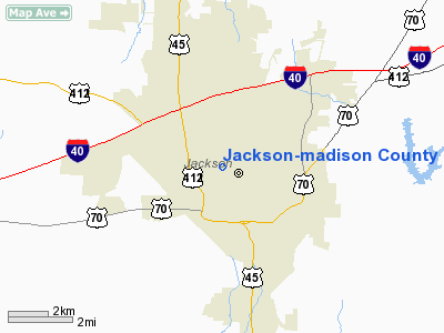
Jackson-madison County General Hospital Heliport |
Location & QuickFacts
| FAA Information Effective: | 2008-09-25 |
| Airport Identifier: | TN05 |
| Airport Status: | Operational |
| Longitude/Latitude: | 088-49-52.0000W/35-38-14.0000N
-88.831111/35.637222 (Estimated) |
| Elevation: | 432 ft / 131.67 m (Estimated) |
| Land: | 0 acres |
| From nearest city: | 0 nautical miles N of Jackson, TN |
| Location: | Madison County, TN |
| Magnetic Variation: | 01E (1985) |
Owner & Manager
| Ownership: | Publicly owned |
| Owner: | Jackson-madison Co Gen Hosp |
| Address: | 708 West Forest
Jackson, TN 38301 |
| Phone number: | 731-425-5000 |
| Manager: | Jeff Halter |
| Address: | 708 West Forest
Jackson, TN 38301 |
| Phone number: | 731-425-8002 |
Airport Operations and Facilities
| Airport Use: | Private
MEDICAL |
| Wind indicator: | Yes |
| Segmented Circle: | No |
| Control Tower: | No |
| Lighting Schedule: | PHONE REQ
FOR ROTG BCN AND PERIMETER LIGHTS CALL 901-425-6006. |
| Beacon Color: | Clear-Green-Yellow (heliport) |
| Sectional chart: | Memphis |
| Region: | ASO - Southern |
| Boundary ARTCC: | ZME - Memphis |
| Tie-in FSS: | MKL - Jackson |
| FSS Toll Free: | 1-800-WX-BRIEF |
Runway Information
Helipad H1
| Dimension: | 45 x 45 ft / 13.7 x 13.7 m |
| Surface: | DECK,
ALUMINUM |
| |
Runway H1 |
Runway |
| Traffic Pattern: | Left | Left |
|
Radio Navigation Aids
| ID |
Type |
Name |
Ch |
Freq |
Var |
Dist |
| TGC | NDB | Gibson | | 378.00 | 01E | 17.9 nm |
| BAV | NDB | Hardeman | | 404.00 | 01E | 27.4 nm |
| SZY | NDB | Sibley | | 386.00 | 01E | 28.6 nm |
| HZD | NDB | Huntingdon | | 217.00 | 00E | 32.4 nm |
| DNT | NDB | Nally Dunston | | 343.00 | 01W | 35.3 nm |
| COO | NDB | Covington | | 326.00 | 02E | 37.1 nm |
| FYE | NDB | Somerville | | 255.00 | 00E | 37.8 nm |
| HHY | NDB | Pinhook | | 346.00 | 01W | 38.4 nm |
| UC | NDB | Obion | | 212.00 | 00E | 40.5 nm |
| TIQ | NDB | Trainer | | 410.00 | 00E | 42.0 nm |
| MKL | VOR/DME | Mc Kellar | 057X | 112.00 | 02E | 4.4 nm |
| JKS | VOR/DME | Jacks Creek | 031X | 109.40 | 02E | 23.2 nm |
| DYR | VORTAC | Dyersburg | 115X | 116.80 | 03E | 33.0 nm |
Remarks
- PRVDD VFR/PVT USE; AND THE SUPPORT GUY WIRES FOR COMMUNICATIONS TOWER ARE RELOCATED.
Images and information placed above are from
http://www.airport-data.com/airport/TN05/
We thank them for the data!
| General Info
|
| Country |
United States
|
| State |
TENNESSEE
|
| FAA ID |
TN05
|
| Latitude |
35-38-08.259N
|
| Longitude |
088-49-55.210W
|
| Elevation |
432 feet
|
| Near City |
JACKSON
|
We don't guarantee the information is fresh and accurate. The data may
be wrong or outdated.
For more up-to-date information please refer to other sources.
|
|


