 |
|
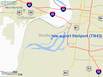
Isle-a-port Stolport Airport |
Location & QuickFacts
| FAA Information Effective: | 2008-09-25 |
| Airport Identifier: | TN43 |
| Airport Status: | Operational |
| Longitude/Latitude: | 090-06-50.3340W/35-05-45.3290N
-90.113982/35.095925 (Estimated) |
| Elevation: | 215 ft / 65.53 m (Estimated) |
| Land: | 170 acres |
| From nearest city: | 0 nautical miles N of Memphis, TN |
| Location: | Shelby County, TN |
| Magnetic Variation: | 02E (1985) |
Owner & Manager
| Ownership: | Privately owned |
| Owner: | Grosvenor Estate Llc
OWNERS: JOHN EVANS PETREE & FLORENCE PETREE GOSNELL & PHOEBE ELIZABETH PETREE & PHOEBE GROSVENOR PETREE WALSH & KATHERINE PETREE CHIAPELLA. |
| Address: | 1786 Glenwood Pl
Memphis, TN 38104 |
| Phone number: | 901-274-5455 |
| Manager: | Henry Grosvenor |
| Address: | 653 South Mc Lean
Memphis, TN 38104 |
| Phone number: | 901-680-0380 |
Airport Operations and Facilities
| Airport Use: | Private |
| Wind indicator: | Yes |
| Segmented Circle: | No |
| Control Tower: | No |
| Lighting Schedule: | PHONE REQ |
| Landing fee charge: | No |
| Sectional chart: | Memphis |
| Region: | ASO - Southern |
| Boundary ARTCC: | ZME - Memphis |
| Tie-in FSS: | MKL - Jackson |
| FSS on Airport: | No |
| FSS Toll Free: | 1-800-WX-BRIEF |
Airport Communications
Airport Services
Runway Information
Runway 03/21
| Dimension: | 3200 x 110 ft / 975.4 x 33.5 m |
| Surface: | TURF, Poor Condition
GRASS EXTREMELY TALL ON SIDES OF RY; SURFACE ROUGH AND UNEVEN. |
| |
Runway 03 |
Runway 21 |
| Traffic Pattern: | Left | Right |
| Displaced threshold: | 100.00 ft | 500.00 ft |
| Obstruction: | 97 ft trees, 1000.0 ft from runway, 200 ft left of centerline, 10:1 slope to clear | 101 ft trees, 1300.0 ft from runway, 250 ft right of centerline, 12:1 slope to clear |
|
Radio Navigation Aids
| ID |
Type |
Name |
Ch |
Freq |
Var |
Dist |
| ME | NDB | Elvis | | 287.00 | 01E | 2.9 nm |
| AWM | NDB | West Memphis | | 362.00 | 01E | 6.4 nm |
| SPQ | NDB | Spain | | 414.00 | 04E | 7.0 nm |
| MIG | NDB | Millington | | 232.00 | 04E | 14.1 nm |
| OLV | NDB | Olive Branch | | 275.00 | 01E | 17.5 nm |
| FCY | NDB | Forrest City | | 332.00 | 01E | 33.8 nm |
| FYE | NDB | Somerville | | 255.00 | 00E | 36.1 nm |
| BPW | NDB | Osceola | | 239.00 | 02E | 36.2 nm |
| COO | NDB | Covington | | 326.00 | 02E | 39.3 nm |
| HEE | NDB | Thompson-robbins | | 251.00 | 01E | 42.0 nm |
| MXA | NDB | Manila | | 282.00 | 01E | 47.9 nm |
| GQE | VOR/DME | Gilmore | 077X | 113.00 | 04E | 23.4 nm |
| UJM | VOR/DME | Marvell | 033X | 109.60 | 01E | 41.8 nm |
| MEM | VORTAC | Memphis | 122X | 117.50 | 01E | 8.1 nm |
| HLI | VORTAC | Holly Springs | 071X | 112.40 | 03E | 36.2 nm |
| MEM | VOT | Memphis Metropolitn | | 111.00 | | 7.2 nm |
Remarks
- RY 03/21 OCCASIONALLY FLOODED.
- OCCASIONAL SMALL BLIMP OPNS WITHIN ARPT AREA.
Images and information placed above are from
http://www.airport-data.com/airport/TN43/
We thank them for the data!
| General Info
|
| Country |
United States
|
| State |
TENNESSEE
|
| FAA ID |
TN43
|
| Latitude |
35-05-45.329N
|
| Longitude |
090-06-50.334W
|
| Elevation |
215 feet
|
| Near City |
MEMPHIS
|
We don't guarantee the information is fresh and accurate. The data may
be wrong or outdated.
For more up-to-date information please refer to other sources.
|
|


