 |
|
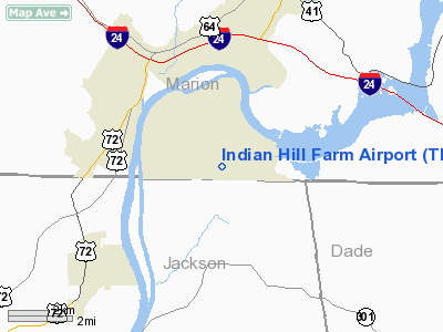
Location & QuickFacts
| FAA Information Effective: | 2008-09-25 |
| Airport Identifier: | TN50 |
| Airport Status: | Operational |
| Longitude/Latitude: | 085-39-02.8860W/34-59-29.2850N
-85.650802/34.991468 (Estimated) |
| Elevation: | 676 ft / 206.04 m (Surveyed) |
| Land: | 0 acres |
| From nearest city: | 3 nautical miles SE of New Hope, TN |
| Location: | Marion County, TN |
| Magnetic Variation: | 01W (1985) |
Owner & Manager
| Ownership: | Privately owned |
| Owner: | R. Boggild |
| Address: | 429 Graham Home Place Road
South Pittsburg, TN 37380 |
| Phone number: | 615-837-8537 |
| Manager: | R. Boggild |
| Address: | 429 Graham Home Place Road
South Pittsburg, TN 37380 |
| Phone number: | 615-837-8537 |
Airport Operations and Facilities
| Airport Use: | Private |
| Wind indicator: | Yes |
| Segmented Circle: | No |
| Control Tower: | No |
| Landing fee charge: | No |
| Sectional chart: | Atlanta |
| Region: | ASO - Southern |
| Boundary ARTCC: | ZME - Memphis |
| Tie-in FSS: | BNA - Nashville |
| FSS on Airport: | No |
| FSS Toll Free: | 1-800-WX-BRIEF |
Runway Information
Runway 04/22
| Dimension: | 2900 x 65 ft / 883.9 x 19.8 m |
| Surface: | TURF, |
| |
Runway 04 |
Runway 22 |
| Traffic Pattern: | Left | Right |
| Obstruction: | 30 ft trees | 50 ft trees, 0.0 ft from runway |
|
Radio Navigation Aids
| ID |
Type |
Name |
Ch |
Freq |
Var |
Dist |
| SYI | FAN MARKER | Bomar | | | 01W | 49.8 nm |
| APT | NDB | Jasper | | 382.00 | 02W | 5.3 nm |
| UOS | NDB | Sewanee | | 275.00 | 02E | 17.6 nm |
| BGF | NDB | Boiling Fork | | 263.00 | 02W | 23.4 nm |
| CQN | NDB | Daisy | | 341.00 | 02W | 26.5 nm |
| FTP | NDB | Fort Payne | | 426.00 | 01W | 28.3 nm |
| UWI | NDB | Whitfield | | 400.00 | 03W | 36.8 nm |
| HDI | NDB | Hardwick | | 369.00 | 01W | 37.9 nm |
| ULH | NDB | Burwi | | 332.00 | 03W | 40.5 nm |
| TNY | NDB | Kelso | | 358.00 | 01W | 44.7 nm |
| DTE | NDB | Mark Anton | | 394.00 | 02W | 46.0 nm |
| RN | NDB | Warri | | 209.00 | 02W | 46.1 nm |
| OYD | NDB | Floyd | | 388.00 | 02W | 48.1 nm |
| UXM | VOR | Tullahoma Regional | | 109.65 | 03W | 37.4 nm |
| GQO | VORTAC | Choo Choo | 105X | 115.80 | 01E | 24.6 nm |
| RQZ | VORTAC | Rocket | 059X | 112.20 | 02E | 49.9 nm |
Remarks
- VFR OPERATIONS/PRIVATE USE
Images and information placed above are from
http://www.airport-data.com/airport/TN50/
We thank them for the data!
| General Info
|
| Country |
United States
|
| State |
TENNESSEE
|
| FAA ID |
TN50
|
| Latitude |
34-59-29.285N
|
| Longitude |
085-39-02.886W
|
| Elevation |
676 feet
|
| Near City |
NEW HOPE
|
We don't guarantee the information is fresh and accurate. The data may
be wrong or outdated.
For more up-to-date information please refer to other sources.
|
|


