|
|
| Humphreys County Airport |
 |
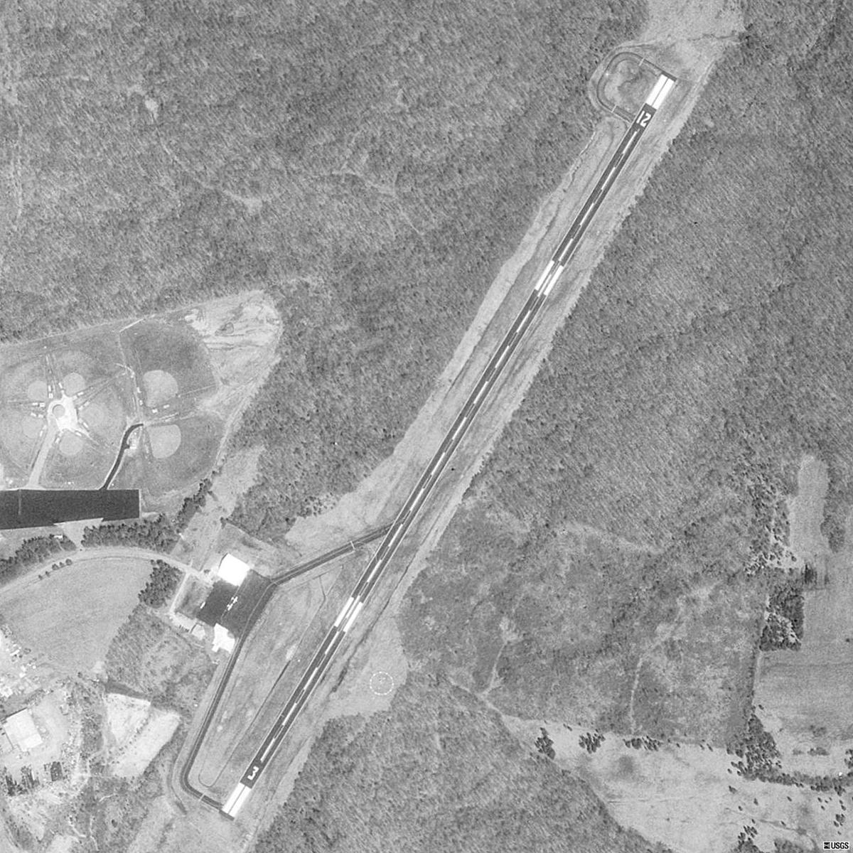
| USGS aerial photo as of 01 April 1998 |
| IATA: none – ICAO: none – FAA LID: 0M5 |
| Summary |
| Airport type |
Public |
| Owner |
Humphreys County |
| Serves |
Waverly, Tennessee |
| Elevation AMSL |
756 ft / 230 m |
| Coordinates |
36°7′0″N 87°44′17″W / 36.116667°N 87.73806°W / 36.116667; -87.73806Coordinates: 36°7′0″N 87°44′17″W / 36.116667°N 87.73806°W / 36.116667; -87.73806 |
| Runways |
| Direction |
Length |
Surface |
| ft |
m |
| 3/21 |
4,000 |
1,219 |
Asphalt |
| Statistics (2000) |
| Aircraft operations |
11,860 |
| Based aircraft |
18 |
| Source: Federal Aviation Administration |
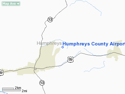
Humphreys County Airport (FAA LID: 0M5) is a county-owned public-use airport located three nautical miles (6 km) northeast of the central business district of Waverly, a city in Humphreys County, Tennessee, United States.
Facilities and aircraft
Humphreys County Airport covers an area of 160 acres (65 ha) at an elevation of 756 feet (230 m) above mean sea level. It has one asphalt paved runway designated 3/21 which measures 4,000 by 75 feet (1,219 x 23 m).
For the 12-month period ending July 12, 2000, the airport had 11,860 aircraft operations, an average of 32 per day: 92% general aviation, 4% air taxi and 4% military. At that time there were 18 aircraft based at this airport: 78% single-engine, 6% multi-engine and 17% ultralight.
The above content comes from Wikipedia and is published under free licenses – click here to read more.
Location & QuickFacts
| FAA Information Effective: | 2008-09-25 |
| Airport Identifier: | 0M5 |
| Airport Status: | Operational |
| Longitude/Latitude: | 087-44-17.3720W/36-06-59.7590N
-87.738159/36.116600 (Estimated) |
| Elevation: | 756 ft / 230.43 m (Surveyed) |
| Land: | 160 acres |
| From nearest city: | 3 nautical miles NE of Waverly, TN |
| Location: | Humphreys County, TN |
| Magnetic Variation: | 00E (1990) |
Owner & Manager
| Ownership: | Publicly owned |
| Owner: | Humphreys County |
| Address: | County Courthouse,
Waverly, TN 37185 |
| Phone number: | 731-296-7795 |
| Manager: | Shay Winsett |
| Address: | 1005 Airport Road
Waverly, TN 37185 |
| Phone number: | 731-296-2719 |
Airport Operations and Facilities
| Airport Use: | Open to public |
| Wind indicator: | Yes |
| Segmented Circle: | Yes |
| Control Tower: | No |
| Lighting Schedule: | DUSK-DAWN |
| Beacon Color: | Clear-Green (lighted land airport) |
| Landing fee charge: | No |
| Sectional chart: | St Louis |
| Region: | ASO - Southern |
| Boundary ARTCC: | ZME - Memphis |
| Tie-in FSS: | MKL - Jackson |
| FSS on Airport: | No |
| FSS Toll Free: | 1-800-WX-BRIEF |
| NOTAMs Facility: | MKL (NOTAM-d service avaliable) |
| Federal Agreements: | NGY |
Airport Communications
| CTAF: | 122.800 |
| Unicom: | 122.800 |
Airport Services
| Fuel available: | 100LLA
SELF-SVC CREDIT CARD FUEL AVBL 24 HRS. |
| Bottled Oxygen: | NONE |
| Bulk Oxygen: | NONE |
Runway Information
Runway 03/21
| Dimension: | 4000 x 75 ft / 1219.2 x 22.9 m |
| Surface: | ASPH, Good Condition |
| Weight Limit: | Single wheel: 30000 lbs. |
| Edge Lights: | Medium |
| |
Runway 03 |
Runway 21 |
| Longitude: | 087-44-29.6870W | 087-44-05.0540W |
| Latitude: | 36-06-42.6930N | 36-07-16.8230N |
| Elevation: | 755.00 ft | 733.00 ft |
| Alignment: | 30 | 127 |
| Traffic Pattern: | Left | Left |
| Markings: | Non-precision instrument, Good Condition | Non-precision instrument, Good Condition |
| Crossing Height: | 26.00 ft | 26.00 ft |
| VASI: | 2-box on left side
RY 03 VASI OTS INDEFLY. | 2-box on left side
VASI OTS INDEFLY. |
| Visual Glide Angle: | 3.00° | 3.00° |
| Obstruction: | 40 ft trees, 846.0 ft from runway, 83 ft right of centerline, 16:1 slope to clear | 39 ft trees, 603.0 ft from runway, 70 ft right of centerline, 10:1 slope to clear |
|
Radio Navigation Aids
| ID |
Type |
Name |
Ch |
Freq |
Var |
Dist |
| AEY | NDB | Waverly | | 329.00 | 00E | 0.2 nm |
| DMZ | NDB | Dickson | | 203.00 | 01W | 14.9 nm |
| TIQ | NDB | Trainer | | 410.00 | 00E | 33.8 nm |
| HZD | NDB | Huntingdon | | 217.00 | 00E | 35.4 nm |
| JHG | NDB | Hohenwald | | 257.00 | 01W | 39.7 nm |
| FK | NDB | Airbe | | 273.00 | 01W | 40.5 nm |
| ON | NDB | Music | | 279.00 | 03W | 41.2 nm |
| PBC | NDB | Maury County | | 365.00 | 01W | 43.9 nm |
| PED | NDB | Needmore | | 221.00 | 01W | 47.1 nm |
| HIX | NDB | Honey Grove | | 356.00 | 01W | 49.8 nm |
| HXW | TACAN | Screaming Eagle | 096X | | 01W | 35.6 nm |
| CKV | VOR/DME | Clarksville | 043X | 110.60 | 01W | 34.2 nm |
| JKS | VOR/DME | Jacks Creek | 031X | 109.40 | 02E | 43.4 nm |
| GHM | VORTAC | Graham | 053X | 111.60 | 03E | 22.0 nm |
Remarks
- TREES ALONG BOTH SIDES OF RWY VIOLATE 7:1 TRANSITIONAL SURFACE.
- PRIM SFC ONLY 300' WIDE.
- COMPUTERIZED LOCAL WX CONDS & FCSTS AVBL AT TERMINAL.
- NO RADIO CONTROLLED MODEL ACFT PERMITTED.
- GCO AVBL ON FREQ 135.075 THRU MKL AFSS.
- GCO OTS INDEFLY.
Images and information placed above are from
http://www.airport-data.com/airport/0M5/
We thank them for the data!
|
|