 |
|
Coordinates: 35°13′12″N 084°49′57″W / 35.22°N 84.8325°W / 35.22; -84.8325
Hardwick Field
Cleveland Municipal Airport |
| IATA: none – ICAO: KHDI – FAA LID: HDI |
| Summary |
| Airport type |
Public |
| Owner |
City of Cleveland |
| Serves |
Cleveland, Tennessee |
| Elevation AMSL |
874 ft / 266 m |
| Website |
CityOfClevelandTN.com/... |
| Runways |
| Direction |
Length |
Surface |
| ft |
m |
| 3/21 |
3,300 |
1,006 |
Asphalt |
| Statistics (1999) |
| Aircraft operations |
12,197 |
| Based aircraft |
40 |
| Source: Federal Aviation Administration |
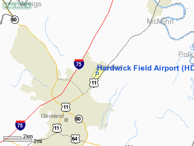
Hardwick Field (ICAO: KHDI, FAA LID: HDI), also known as Cleveland Municipal Airport, is a public airport located four miles (6 km) northeast of the central business district of Cleveland, in Bradley County, Tennessee, United States. It is owned by the City of Cleveland.
Although most U.S. airports use the same three-letter location identifier for the FAA and IATA, Hardwick Field is assigned HDI by the FAA but has no designation from the IATA.
Facilities and aircraft
Hardwick Field covers an area of 103 acres (42 ha) which contains one asphalt paved runway (3/21) measuring 3,300 x 75 ft (1,006 x 23 m).
For the 12-month period ending March 4, 1999, the airport had 12,197 aircraft operations, an average of 33 per day: 93% general aviation, 7% air taxi and <1% military. There are 40 aircraft based at this airport: 60% single-engine, 38% multi-engine and 3% jet.
The above content comes from Wikipedia and is published under free licenses – click here to read more.
Location & QuickFacts
| FAA Information Effective: | 2008-09-25 |
| Airport Identifier: | HDI |
| Airport Status: | Operational |
| Longitude/Latitude: | 084-49-56.7960W/35-13-12.2630N
-84.832443/35.220073 (Estimated) |
| Elevation: | 874 ft / 266.40 m (Surveyed) |
| Land: | 103 acres |
| From nearest city: | 4 nautical miles NE of Cleveland, TN |
| Location: | Bradley County, TN |
| Magnetic Variation: | 04W (2005) |
Owner & Manager
| Ownership: | Publicly owned |
| Owner: | City Of Cleveland |
| Address: | City Hall
Cleveland, TN 37311 |
| Phone number: | 423-559-3352
CITY MANAGER. |
| Manager: | Corey Shipley |
| Address: | 405 Airport Road
Cleveland, TN 37311 |
| Phone number: | 423-479-4880 |
Airport Operations and Facilities
| Airport Use: | Open to public |
| Wind indicator: | Yes |
| Segmented Circle: | Yes |
| Control Tower: | No |
| Lighting Schedule: | DUSK-DAWN |
| Beacon Color: | Clear-Green (lighted land airport) |
| Landing fee charge: | No |
| Sectional chart: | Atlanta |
| Region: | ASO - Southern |
| Boundary ARTCC: | ZTL - Atlanta |
| Tie-in FSS: | BNA - Nashville |
| FSS on Airport: | No |
| FSS Toll Free: | 1-800-WX-BRIEF |
| NOTAMs Facility: | BNA (NOTAM-d service avaliable) |
| Federal Agreements: | N1 |
Airport Communications
| CTAF: | 122.800 |
| Unicom: | 122.800 |
Airport Services
| Fuel available: | 100LL |
| Airframe Repair: | MAJOR |
| Power Plant Repair: | MAJOR |
| Bottled Oxygen: | NONE |
| Bulk Oxygen: | NONE |
Runway Information
Runway 03/21
| Dimension: | 3300 x 75 ft / 1005.8 x 22.9 m |
| Surface: | ASPH, Fair Condition |
| Weight Limit: | Single wheel: 17000 lbs.
Dual wheel: 23000 lbs. |
| Edge Lights: | Low |
| |
Runway 03 |
Runway 21 |
| Longitude: | 084-50-05.3600W | 084-49-47.7000W |
| Latitude: | 35-12-57.3900N | 35-13-26.6000N |
| Elevation: | 828.00 ft | 874.00 ft |
| Alignment: | 26 | 127 |
| Traffic Pattern: | Left | Left |
| Markings: | Basic, Good Condition | Basic, Good Condition |
| VASI: | 2-box SAVASI on left side | 2-box SAVASI on left side |
| Runway End Identifier: | Yes | Yes |
| Obstruction: | 38 ft trees, 480.0 ft from runway, 222 ft left of centerline, 7:1 slope to clear
+2 FT ROAD AT 130 FT; 0 BOTH. | 89 ft trees, 845.0 ft from runway, 211 ft right of centerline, 7:1 slope to clear |
|
Radio Navigation Aids
| ID |
Type |
Name |
Ch |
Freq |
Var |
Dist |
| HDI | NDB | Hardwick | | 369.00 | 01W | 5.4 nm |
| CQN | NDB | Daisy | | 341.00 | 02W | 16.3 nm |
| DTE | NDB | Mark Anton | | 394.00 | 02W | 16.5 nm |
| MMI | NDB | Mc Minn County | | 242.00 | 03W | 16.9 nm |
| UWI | NDB | Whitfield | | 400.00 | 03W | 26.5 nm |
| MNV | NDB | Madisonville | | 361.00 | 04W | 29.4 nm |
| APT | NDB | Jasper | | 382.00 | 02W | 38.2 nm |
| TTQ | NDB | Tomotla | | 335.00 | 01W | 43.5 nm |
| OUK | NDB | Calhoun | | 323.00 | 02W | 49.4 nm |
| JZP | NDB | Pickens County | | 285.00 | 04W | 49.4 nm |
| GQO | VORTAC | Choo Choo | 105X | 115.80 | 01E | 22.2 nm |
| HCH | VORTAC | Hinch Mountain | 123X | 117.60 | 02W | 34.5 nm |
| HRS | VORTAC | Harris | 035X | 109.80 | 00E | 48.1 nm |
Remarks
- TREES VIOLATE 7:1 TRANSITIONAL BOTH SIDES RWY 21.
- RECOMMEND HIGH PERFORMANCE ACFT LAND RWY 03 TKOF RWY 21 WHEN WND CONDITION NOT A FACTOR DUE TO RWY GRADIENT & APCH OBSTNS.
- DEER ON & INVOF ARPT.
Images and information placed above are from
http://www.airport-data.com/airport/HDI/
We thank them for the data!
| General Info
|
| Country |
United States
|
| State |
TENNESSEE
|
| FAA ID |
HDI
|
| Latitude |
35-13-12.263N
|
| Longitude |
084-49-56.796W
|
| Elevation |
874 feet
|
| Near City |
CLEVELAND
|
We don't guarantee the information is fresh and accurate. The data may
be wrong or outdated.
For more up-to-date information please refer to other sources.
|
|


