 |
|
Greeneville-greene County Muni Airport |
Coordinates: 36°11′35″N 082°48′54″W / 36.19306°N 82.815°W / 36.19306; -82.815
| Greeneville-Greene County Municipal Airport |
| IATA: GCY – ICAO: KGCY – FAA LID: GCY |
| Summary |
| Airport type |
Public |
| Owner |
City of Greeneville & Greene County |
| Location |
Greeneville, Tennessee |
| Elevation AMSL |
1,608 ft / 490 m |
| Runways |
| Direction |
Length |
Surface |
| ft |
m |
| 5/23 |
6,302 |
1,921 |
Asphalt |
| Statistics (1998) |
| Aircraft operations |
43,500 |
| Source: Federal Aviation Administration |
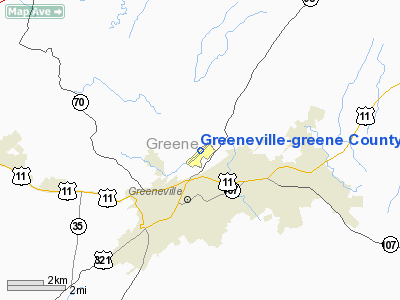
Greeneville-Greene County Municipal Airport (IATA: GCY, ICAO: KGCY, FAA LID: GCY) is a public airport located two miles (3 km) north of the central business district of Greeneville, a city in Greene County, Tennessee, United States. It is owned by the City of Greeneville and Greene County.
Facilities and aircraft
Greeneville-Greene County Municipal Airport covers an area of 160 acres (65 ha) which contains one asphalt paved runway (5/23) measuring 6,302 x 100 ft (1,921 x 30 m). For the 12-month period ending March 30, 1998, the airport had 43,500 aircraft operations, an average of 119 per day: 69% general aviation, 30% air taxi and 1% military.
The above content comes from Wikipedia and is published under free licenses – click here to read more.
Location & QuickFacts
| FAA Information Effective: | 2008-09-25 |
| Airport Identifier: | GCY |
| Airport Status: | Operational |
| Longitude/Latitude: | 082-48-54.2530W/36-11-34.7670N
-82.815070/36.192991 (Estimated) |
| Elevation: | 1608 ft / 490.12 m (Surveyed) |
| Land: | 160 acres |
| From nearest city: | 2 nautical miles N of Greeneville, TN |
| Location: | Greene County, TN |
| Magnetic Variation: | 04W (1990) |
Owner & Manager
| Ownership: | Publicly owned |
| Owner: | City Greeneville & Greene Co. |
| Address: | 200 N College St
Greeneville, TN 37743 |
| Phone number: | 423-639-7105 |
| Manager: | Sam Biddle |
| Address: | 246 Airport Road
Greeneville, TN 37745 |
| Phone number: | 423-639-6275 |
Airport Operations and Facilities
| Airport Use: | Open to public |
| Wind indicator: | Yes |
| Segmented Circle: | No |
| Control Tower: | No |
| Lighting Schedule: | DUSK-DAWN |
| Beacon Color: | Clear-Green (lighted land airport) |
| Landing fee charge: | No |
| Sectional chart: | Cincinnati |
| Region: | ASO - Southern |
| Boundary ARTCC: | ZTL - Atlanta |
| Tie-in FSS: | BNA - Nashville |
| FSS on Airport: | No |
| FSS Toll Free: | 1-800-WX-BRIEF |
| NOTAMs Facility: | BNA (NOTAM-d service avaliable) |
| Federal Agreements: | NGY |
Airport Communications
| CTAF: | 122.700 |
| Unicom: | 122.700 |
Airport Services
| Fuel available: | 100LLA |
| Airframe Repair: | MINOR |
| Power Plant Repair: | MINOR |
| Bottled Oxygen: | LOW |
| Bulk Oxygen: | LOW |
Runway Information
Runway 05/23
| Dimension: | 6302 x 100 ft / 1920.8 x 30.5 m |
| Surface: | ASPH, Good Condition |
| Weight Limit: | Single wheel: 22000 lbs.
Dual wheel: 35000 lbs. |
| Edge Lights: | Medium |
| |
Runway 05 |
Runway 23 |
| Longitude: | 082-49-22.4800W | 082-48-25.9400W |
| Latitude: | 36-11-13.6400N | 36-11-55.8400N |
| Elevation: | 1564.00 ft | 1604.00 ft |
| Alignment: | 47 | 127 |
| ILS Type: | LOCALIZER
| |
| Traffic Pattern: | Left | Right |
| Markings: | Non-precision instrument, Good Condition | Non-precision instrument, Good Condition |
| Crossing Height: | 28.00 ft | 31.00 ft |
| VASI: | 2-box on left side | 2-box on left side |
| Visual Glide Angle: | 3.50° | 4.00° |
| Runway End Identifier: | Yes | Yes |
| Obstruction: | 48 ft trees, 1050.0 ft from runway, 393 ft right of centerline, 17:1 slope to clear
TREE 9' RGT EXTENDED CNTRLN. | 79 ft trees, 1300.0 ft from runway, 389 ft right of centerline, 13:1 slope to clear
TREES 61' RGT EXTENDED CNTRLN. |
|
Radio Navigation Aids
| ID |
Type |
Name |
Ch |
Freq |
Var |
Dist |
| DYQ | NDB | Dulaney | | 263.00 | 04W | 5.0 nm |
| RVN | NDB | Rogersville | | 329.00 | 04W | 16.2 nm |
| BO | NDB | Booie | | 221.00 | 04W | 19.8 nm |
| EZT | NDB | Elizabethton | | 275.00 | 02W | 27.4 nm |
| JXT | NDB | Jefferson | | 346.00 | 04W | 32.4 nm |
| LQV | NDB | Long Hollow | | 252.00 | 03W | 33.3 nm |
| BAR | NDB | Hemlock | | 320.00 | 02W | 45.4 nm |
| JJO | NDB | Mountain City | | 396.00 | 04W | 49.8 nm |
| SOT | VORTAC | Snowbird | 025X | 108.80 | 04W | 26.8 nm |
| HMV | VORTAC | Holston Mountain | 093X | 114.60 | 04W | 36.3 nm |
Remarks
- PARACHUTE JUMPING WKENDS SR-SS.
- PAEW ADJ RY AND TWY.
Images and information placed above are from
http://www.airport-data.com/airport/GCY/
We thank them for the data!
| General Info
|
| Country |
United States
|
| State |
TENNESSEE
|
| FAA ID |
GCY
|
| Latitude |
36-11-34.767N
|
| Longitude |
082-48-54.253W
|
| Elevation |
1608 feet
|
| Near City |
GREENEVILLE
|
We don't guarantee the information is fresh and accurate. The data may
be wrong or outdated.
For more up-to-date information please refer to other sources.
|
|


