 |
|
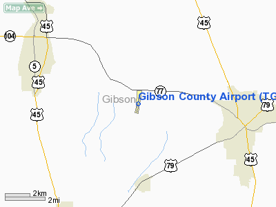
Location & QuickFacts
| FAA Information Effective: | 2008-09-25 |
| Airport Identifier: | TGC |
| Airport Status: | Operational |
| Longitude/Latitude: | 088-50-56.1850W/35-55-56.8370N
-88.848940/35.932455 (Estimated) |
| Elevation: | 359 ft / 109.42 m (Surveyed) |
| Land: | 104 acres |
| From nearest city: | 5 nautical miles SE of Trenton, TN |
| Location: | Gibson County, TN |
| Magnetic Variation: | 01E (1990) |
Owner & Manager
| Ownership: | Publicly owned |
| Owner: | City Of Milan & Gibson Co |
| Address: | Gibson County Courthouse
Trenton, TN 38382 |
| Phone number: | 731-855-4550 |
| Manager: | Cindy Green (temp) |
| Address: | 56 Airport Rd
Milan, TN 38358 |
| Phone number: | 731-686-1524 |
Airport Operations and Facilities
| Airport Use: | Open to public |
| Wind indicator: | Yes |
| Segmented Circle: | Yes |
| Control Tower: | No |
| Lighting Schedule: | DUSK-DAWN |
| Beacon Color: | Clear-Green (lighted land airport) |
| Landing fee charge: | No |
| Sectional chart: | Memphis |
| Region: | ASO - Southern |
| Boundary ARTCC: | ZME - Memphis |
| Tie-in FSS: | MKL - Jackson |
| FSS on Airport: | No |
| FSS Toll Free: | 1-800-WX-BRIEF |
| NOTAMs Facility: | MKL (NOTAM-d service avaliable) |
| Federal Agreements: | NGY |
Airport Communications
| CTAF: | 122.800 |
| Unicom: | 122.800 |
Airport Services
| Fuel available: | 100LLA |
| Bottled Oxygen: | NONE |
| Bulk Oxygen: | HIGH |
Runway Information
Runway 01/19
| Dimension: | 4800 x 75 ft / 1463.0 x 22.9 m |
| Surface: | ASPH, Poor Condition |
| Weight Limit: | Single wheel: 30000 lbs. |
| Edge Lights: | Medium |
| |
Runway 01 |
Runway 19 |
| Longitude: | 088-51-00.6880W | 088-50-51.6820W |
| Latitude: | 35-55-33.3860N | 35-56-20.2890N |
| Elevation: | 359.00 ft | 355.00 ft |
| Alignment: | 9 | 127 |
| Traffic Pattern: | Left | Left |
| Markings: | Non-precision instrument, Good Condition | Non-precision instrument, Good Condition |
| VASI: | 2-box on left side
RY 01 VASI OTS INDEFLY. | 2-box on left side |
| Runway End Identifier: | Yes | Yes
RY 19 REIL OTS INDEFLY. |
| Obstruction: | 14 ft trees, 273.0 ft from runway, 3 ft left of centerline, 5:1 slope to clear | 62 ft tree, 1450.0 ft from runway, 55 ft right of centerline, 20:1 slope to clear |
|
Radio Navigation Aids
| ID |
Type |
Name |
Ch |
Freq |
Var |
Dist |
| TGC | NDB | Gibson | | 378.00 | 01E | 0.1 nm |
| HZD | NDB | Huntingdon | | 217.00 | 00E | 20.8 nm |
| UC | NDB | Obion | | 212.00 | 00E | 23.1 nm |
| DNT | NDB | Nally Dunston | | 343.00 | 01W | 27.4 nm |
| TIQ | NDB | Trainer | | 410.00 | 00E | 28.4 nm |
| COO | NDB | Covington | | 326.00 | 02E | 41.5 nm |
| BAV | NDB | Hardeman | | 404.00 | 01E | 44.2 nm |
| SZY | NDB | Sibley | | 386.00 | 01E | 44.9 nm |
| GGK | NDB | Mayfield | | 401.00 | 00E | 47.3 nm |
| IUI | NDB | Hicks | | 350.00 | 01E | 47.9 nm |
| MKL | VOR/DME | Mc Kellar | 057X | 112.00 | 02E | 20.0 nm |
| JKS | VOR/DME | Jacks Creek | 031X | 109.40 | 02E | 31.2 nm |
| DYR | VORTAC | Dyersburg | 115X | 116.80 | 03E | 23.4 nm |
Images and information placed above are from
http://www.airport-data.com/airport/TGC/
We thank them for the data!
| General Info
|
| Country |
United States
|
| State |
TENNESSEE
|
| FAA ID |
TGC
|
| Latitude |
35-55-56.837N
|
| Longitude |
088-50-56.185W
|
| Elevation |
359 feet
|
| Near City |
TRENTON
|
We don't guarantee the information is fresh and accurate. The data may
be wrong or outdated.
For more up-to-date information please refer to other sources.
|
|


