 |
|
| Franklin County Airport |
| IATA: UOS – ICAO: KUOS – FAA LID: UOS |
| Summary |
| Airport type |
Public |
| Owner |
Franklin County |
| Location |
Sewanee, Tennessee |
| Elevation AMSL |
1,953 ft / 595 m |
| Coordinates |
35°12′19″N 085°53′53″W / 35.20528°N 85.89806°W / 35.20528; -85.89806 |
| Runways |
| Direction |
Length |
Surface |
| ft |
m |
| 6/24 |
3,700 |
1,128 |
Asphalt |
| Statistics (1999) |
| Aircraft operations |
3,500 |
| Source: Federal Aviation Administration |
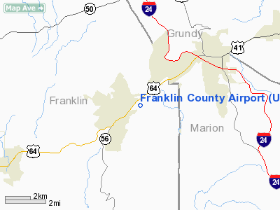
Franklin County Airport (IATA: UOS, ICAO: KUOS, FAA LID: UOS) is a public airport located one mile (2 km) east of the central business district of Sewanee, a town in Franklin County, Tennessee, United States. It is owned by Franklin County.
It is a general aviation airport located atop the Cumberland Plateau. The location is commonly referred to as Monteagle Mountain since it is near one of the most notoriously hazardous stretches of Interstate highway in the United States where Interstate 24 crosses the plateau. The ICAO designation "KUOS" resulted from its proximity to the University of the South. Although the airport is named "Franklin County", it is referred to as "Sewanee" over the radio on Unicom 122.8. History
Franklin County was the home airport of late aviation legend Bill Kershner. He was one of the world's leading experts on spins and spin recovery and was known as the Spin Doctor in the aviation community.
Facilities and aircraft
Franklin County Airport covers an area of 70 acres (28 ha) which contains one asphalt paved runway (6/24) measuring 3,700 x 50 ft (1,128 x 15 m). For the 12-month period ending November 29, 1999, the airport had 3,500 aircraft operations, 100% of which were general aviation.
The above content comes from Wikipedia and is published under free licenses – click here to read more.
Location & QuickFacts
| FAA Information Effective: | 2008-09-25 |
| Airport Identifier: | UOS |
| Airport Status: | Operational |
| Longitude/Latitude: | 085-53-53.3300W/35-12-18.5250N
-85.898147/35.205146 (Estimated) |
| Elevation: | 1953 ft / 595.27 m (Estimated) |
| Land: | 70 acres |
| From nearest city: | 1 nautical miles E of Sewanee, TN |
| Location: | Franklin County, TN |
| Magnetic Variation: | 01W (1985) |
Owner & Manager
| Ownership: | Publicly owned |
| Owner: | Franklin County
UNIVERSITY OF THE SOUTH - SEWANEE, TN - ATTN: RANDALL TAYLOR, 931-558-1250. |
| Address: | County Courthouse
Winchester, TN 37398 |
| Phone number: | 931-967-2905 |
| Manager: | Rebecca Gibson |
| Address: | 262 Airport Road
Sewanee, TN 37375 |
| Phone number: | 931-598-1910 |
Airport Operations and Facilities
| Airport Use: | Open to public |
| Wind indicator: | Yes |
| Segmented Circle: | No
WINDSOCK ON TOP OF HANGAR. |
| Control Tower: | No |
| Lighting Schedule: | DUSK-DAWN
ACTVT MIRL RY 06/24 & PAPI RYS 06 & 24 - CTAF |
| Beacon Color: | Clear-Green (lighted land airport)
ROTG BCN LCTD ON TOP OF HANGAR. |
| Landing fee charge: | No |
| Sectional chart: | Atlanta |
| Region: | ASO - Southern |
| Boundary ARTCC: | ZME - Memphis |
| Tie-in FSS: | BNA - Nashville |
| FSS on Airport: | No |
| FSS Toll Free: | 1-800-WX-BRIEF |
| NOTAMs Facility: | BNA (NOTAM-d service avaliable) |
| Federal Agreements: | N1 |
Airport Communications
| CTAF: | 122.800 |
| Unicom: | 122.800 |
Airport Services
| Fuel available: | 100LL |
| Airframe Repair: | NONE |
| Power Plant Repair: | NONE |
| Bottled Oxygen: | NONE |
| Bulk Oxygen: | NONE |
Runway Information
Runway 06/24
| Dimension: | 3700 x 50 ft / 1127.8 x 15.2 m |
| Surface: | ASPH, Good Condition |
| Weight Limit: | Single wheel: 15000 lbs.
Dual wheel: 25000 lbs. |
| Edge Lights: | Medium |
| |
Runway 06 |
Runway 24 |
| Latitude: | | 35-12-25.6000N |
| Elevation: | 0.00 ft | 1953.00 ft |
| Traffic Pattern: | Left | Left |
| Markings: | Basic, Good Condition | Basic, Good Condition |
| Displaced threshold: | 0.00 ft | 200.00 ft |
| VASI: | 2-light PAPI on left side | 2-light PAPI on left side |
| Obstruction: | 32 ft trees, 645.0 ft from runway, 56 ft left of centerline, 14:1 slope to clear | 63 ft trees, 972.0 ft from runway, 14 ft right of centerline, 12:1 slope to clear
24 APCH RATIO 18:1 TO THE DSPLCD THR. |
|
Radio Navigation Aids
| ID |
Type |
Name |
Ch |
Freq |
Var |
Dist |
| SYI | FAN MARKER | Bomar | | | 01W | 32.5 nm |
| UOS | NDB | Sewanee | | 275.00 | 02E | 0.1 nm |
| BGF | NDB | Boiling Fork | | 263.00 | 02W | 8.5 nm |
| APT | NDB | Jasper | | 382.00 | 02W | 17.7 nm |
| ULH | NDB | Burwi | | 332.00 | 03W | 22.8 nm |
| TNY | NDB | Kelso | | 358.00 | 01W | 31.9 nm |
| RN | NDB | Warri | | 209.00 | 02W | 33.5 nm |
| CQN | NDB | Daisy | | 341.00 | 02W | 36.5 nm |
| FTP | NDB | Fort Payne | | 426.00 | 01W | 42.6 nm |
| SKN | NDB | Hurricane | | 256.00 | 02W | 47.0 nm |
| LUG | NDB | Verona | | 251.00 | 00W | 48.1 nm |
| HDI | NDB | Hardwick | | 369.00 | 01W | 48.9 nm |
| HUA | NDB | Redstone | | 287.00 | 00W | 49.4 nm |
| HEM | NDB | Huchn | | 233.00 | 02W | 49.5 nm |
| UXM | VOR | Tullahoma Regional | | 109.65 | 03W | 20.0 nm |
| SYI | VOR/DME | Shelbyville | 027X | 109.00 | 01W | 34.1 nm |
| GQO | VORTAC | Choo Choo | 105X | 115.80 | 01E | 39.5 nm |
| RQZ | VORTAC | Rocket | 059X | 112.20 | 02E | 43.7 nm |
| HSV | VOT | Huntsville | | 111.00 | | 45.0 nm |
Remarks
-
- DEER ON & INVOF RY.
- VFR USE ONLY.
Images and information placed above are from
http://www.airport-data.com/airport/UOS/
We thank them for the data!
| General Info
|
| Country |
United States
|
| State |
TENNESSEE
|
| FAA ID |
UOS
|
| Latitude |
35-12-18.525N
|
| Longitude |
085-53-53.330W
|
| Elevation |
1953 feet
|
| Near City |
SEWANEE
|
We don't guarantee the information is fresh and accurate. The data may
be wrong or outdated.
For more up-to-date information please refer to other sources.
|
|


