 |
|
Coordinates: 35°30′25″N 086°48′14″W / 35.50694°N 86.80389°W / 35.50694; -86.80389
| Ellington Airport |
| IATA: none – ICAO: KLUG – FAA LID: LUG |
| Summary |
| Airport type |
Public |
| Owner |
City of Lewisburg |
| Serves |
Lewisburg, Tennessee |
| Elevation AMSL |
717 ft / 219 m |
| Runways |
| Direction |
Length |
Surface |
| ft |
m |
| 2/20 |
5,002 |
1,525 |
Asphalt |
| Statistics (1998) |
| Aircraft operations |
17,050 |
| Based aircraft |
33 |
| Source: Federal Aviation Administration |
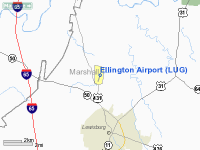
Ellington Airport (ICAO: KLUG, FAA LID: LUG) is a city-owned public-use airport located three miles (5 km) north of the central business district of Lewisburg, a city in Marshall County, Tennessee, United States.
Although most U.S. airports use the same three-letter location identifier for the FAA and IATA, Ellington Airport is assigned LUG by the FAA but has no designation from the IATA (which assigned LUG to Agno Airport in Lugano, Switzerland).
Facilities and aircraft
Ellington Airport covers an area of 200 acres (81 ha) and contains one asphalt paved runway designated 2/20 which measures 5,002 x 75 ft (1,525 x 23 m). For the 12-month period ending July 23, 1998, the airport had 17,050 aircraft operations, an average of 46 per day: 91% general aviation, 9% air taxi and <1% military. At that time there were 33 aircraft based at this airport: 79% single-engine, 18% multi-engine and 3% ultralight.
The above content comes from Wikipedia and is published under free licenses – click here to read more.
Location & QuickFacts
| FAA Information Effective: | 2008-09-25 |
| Airport Identifier: | LUG |
| Airport Status: | Operational |
| Longitude/Latitude: | 086-48-13.9900W/35-30-25.1100N
-86.803886/35.506975 (Estimated) |
| Elevation: | 717 ft / 218.54 m (Surveyed) |
| Land: | 200 acres |
| From nearest city: | 3 nautical miles N of Lewisburg, TN |
| Location: | Marshall County, TN |
| Magnetic Variation: | 00W (1985) |
Owner & Manager
| Ownership: | Publicly owned |
| Owner: | City Of Lewisburg |
| Address: | City Hall Box 1968
Lewisburg, TN 37091 |
| Phone number: | 931-359-1544 |
| Manager: | Clay Derryberry |
| Address: | 1877 Franklin Pike
Lewisburg, TN 37091 |
| Phone number: | 931-359-5003 |
Airport Operations and Facilities
| Airport Use: | Open to public |
| Wind indicator: | Yes |
| Segmented Circle: | Yes |
| Control Tower: | No |
| Lighting Schedule: | DUSK-DAWN |
| Beacon Color: | Clear-Green (lighted land airport) |
| Landing fee charge: | No |
| Sectional chart: | Atlanta |
| Region: | ASO - Southern |
| Boundary ARTCC: | ZME - Memphis |
| Tie-in FSS: | MKL - Jackson |
| FSS on Airport: | No |
| FSS Toll Free: | 1-800-WX-BRIEF |
| NOTAMs Facility: | MKL (NOTAM-d service avaliable) |
| Federal Agreements: | NGY |
Airport Communications
| CTAF: | 122.800 |
| Unicom: | 122.800 |
Airport Services
| Fuel available: | 100LLA |
| Airframe Repair: | MAJOR |
| Power Plant Repair: | MAJOR |
| Bottled Oxygen: | NONE |
| Bulk Oxygen: | NONE |
Runway Information
Runway 02/20
| Dimension: | 5002 x 75 ft / 1524.6 x 22.9 m |
| Surface: | ASPH, Good Condition |
| Weight Limit: | Single wheel: 28000 lbs.
Dual wheel: 41000 lbs. |
| Edge Lights: | Medium |
| |
Runway 02 |
Runway 20 |
| Longitude: | 086-48-23.4080W | 086-48-04.5780W |
| Latitude: | 35-30-01.0630N | 35-30-48.6140N |
| Elevation: | 717.00 ft | 709.00 ft |
| Alignment: | 18 | 127 |
| Traffic Pattern: | Left | Left |
| Markings: | Non-precision instrument, Fair Condition | Non-precision instrument, Fair Condition |
| Crossing Height: | 28.00 ft | 21.00 ft |
| VASI: | 2-box SAVASI on left side | 2-box SAVASI on left side |
| Visual Glide Angle: | 4.00° | 3.50° |
| Runway End Identifier: | Yes | Yes |
| Obstruction: | 67 ft trees, 1269.0 ft from runway, 220 ft right of centerline, 16:1 slope to clear | 43 ft trees, 1239.0 ft from runway, 331 ft right of centerline, 24:1 slope to clear |
|
Radio Navigation Aids
| ID |
Type |
Name |
Ch |
Freq |
Var |
Dist |
| SYI | FAN MARKER | Bomar | | | 01W | 16.6 nm |
| LUG | NDB | Verona | | 251.00 | 00W | 0.5 nm |
| PBC | NDB | Maury County | | 365.00 | 01W | 15.3 nm |
| GZS | NDB | Giles/dcmsnd | | 375.00 | 00E | 24.7 nm |
| TNY | NDB | Kelso | | 358.00 | 01W | 25.8 nm |
| ULH | NDB | Burwi | | 332.00 | 03W | 27.7 nm |
| LRT | NDB | Lawrenceburg | | 269.00 | 00E | 27.7 nm |
| SWZ | NDB | Sewart | | 391.00 | 02W | 31.7 nm |
| FQW | NDB | Walter Hill | | 371.00 | 02W | 34.5 nm |
| JHG | NDB | Hohenwald | | 257.00 | 01W | 40.5 nm |
| BGF | NDB | Boiling Fork | | 263.00 | 02W | 41.1 nm |
| VI | NDB | Opery | | 344.00 | 02W | 42.5 nm |
| CWH | NDB | Capshaw | | 350.00 | 01W | 44.1 nm |
| JUE | NDB | Lebanon | | 414.00 | 02W | 47.6 nm |
| UOS | NDB | Sewanee | | 275.00 | 02E | 48.1 nm |
| DMZ | NDB | Dickson | | 203.00 | 01W | 48.3 nm |
| HUA | NDB | Redstone | | 287.00 | 00W | 48.9 nm |
| UXM | VOR | Tullahoma Regional | | 109.65 | 03W | 28.4 nm |
| SYI | VOR/DME | Shelbyville | 027X | 109.00 | 01W | 18.1 nm |
| GHM | VORTAC | Graham | 053X | 111.60 | 03E | 37.2 nm |
| BNA | VORTAC | Nashville | 088X | 114.10 | 02W | 38.3 nm |
| RQZ | VORTAC | Rocket | 059X | 112.20 | 02E | 43.5 nm |
| HSV | VOT | Huntsville | | 111.00 | | 31.6 nm |
| MQY | VOT | Smyrna | | 110.20 | | 33.3 nm |
| BNA | VOT | Nashville Metropoln | | 108.60 | | 37.7 nm |
Images and information placed above are from
http://www.airport-data.com/airport/LUG/
We thank them for the data!
| General Info
|
| Country |
United States
|
| State |
TENNESSEE
|
| FAA ID |
LUG
|
| Latitude |
35-30-25.110N
|
| Longitude |
086-48-13.990W
|
| Elevation |
717 feet
|
| Near City |
LEWISBURG
|
We don't guarantee the information is fresh and accurate. The data may
be wrong or outdated.
For more up-to-date information please refer to other sources.
|
|


