 |
|
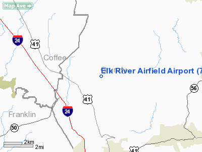
Elk River Airfield Airport |
Location & QuickFacts
| FAA Information Effective: | 2008-09-25 |
| Airport Identifier: | 7TN1 |
| Airport Status: | Operational |
| Longitude/Latitude: | 085-51-12.9200W/35-19-14.2840N
-85.853589/35.320634 (Estimated) |
| Elevation: | 995 ft / 303.28 m (Estimated) |
| Land: | 0 acres |
| From nearest city: | 2 nautical miles NE of Pelham, TN |
| Location: | Grundy County, TN |
| Magnetic Variation: | 01W (1990) |
Owner & Manager
| Ownership: | Privately owned |
| Owner: | Classic Flyers Inc |
| Address: | Po Box 96 Hwy 50
Pelham, TN 37366 |
| Phone number: | 909-952-4425 |
| Manager: | Kent Wilson |
| Address: | 305 North Second Ave #324
Upland, CA 91786-6019 |
| Phone number: | 909-952-4425 |
Airport Operations and Facilities
| Airport Use: | Private |
| Segmented Circle: | No |
| Control Tower: | No |
| Sectional chart: | Atlanta |
| Region: | ASO - Southern |
| Boundary ARTCC: | ZME - Memphis |
| Tie-in FSS: | BNA - Nashville |
| FSS Toll Free: | 1-800-WX-BRIEF |
Runway Information
Runway 10/28
| Dimension: | 3400 x 250 ft / 1036.3 x 76.2 m |
| Surface: | TURF, Fair Condition |
| |
Runway 10 |
Runway 28 |
| Traffic Pattern: | Left | Left |
| Obstruction: | 40 ft pline | 50 ft trees |
|
Radio Navigation Aids
| ID |
Type |
Name |
Ch |
Freq |
Var |
Dist |
| SYI | FAN MARKER | Bomar | | | 01W | 31.5 nm |
| UOS | NDB | Sewanee | | 275.00 | 02E | 7.3 nm |
| BGF | NDB | Boiling Fork | | 263.00 | 02W | 13.6 nm |
| APT | NDB | Jasper | | 382.00 | 02W | 20.5 nm |
| ULH | NDB | Burwi | | 332.00 | 03W | 20.8 nm |
| RN | NDB | Warri | | 209.00 | 02W | 26.3 nm |
| CQN | NDB | Daisy | | 341.00 | 02W | 35.4 nm |
| TNY | NDB | Kelso | | 358.00 | 01W | 35.6 nm |
| SKN | NDB | Hurricane | | 256.00 | 02W | 39.9 nm |
| HEM | NDB | Huchn | | 233.00 | 02W | 42.2 nm |
| FQW | NDB | Walter Hill | | 371.00 | 02W | 46.1 nm |
| DTE | NDB | Mark Anton | | 394.00 | 02W | 46.2 nm |
| HDI | NDB | Hardwick | | 369.00 | 01W | 47.6 nm |
| LUG | NDB | Verona | | 251.00 | 00W | 48.1 nm |
| SWZ | NDB | Sewart | | 391.00 | 02W | 48.5 nm |
| FTP | NDB | Fort Payne | | 426.00 | 01W | 48.9 nm |
| UXM | VOR | Tullahoma Regional | | 109.65 | 03W | 19.6 nm |
| SYI | VOR/DME | Shelbyville | 027X | 109.00 | 01W | 32.1 nm |
| GQO | VORTAC | Choo Choo | 105X | 115.80 | 01E | 40.6 nm |
| RQZ | VORTAC | Rocket | 059X | 112.20 | 02E | 49.6 nm |
| HSV | VOT | Huntsville | | 111.00 | | 49.5 nm |
Remarks
- PRVDD 20:1 APCH SLOPE FOR EACH RY; PLINE TO W IS BURIED OR OBST MKD & RY 10 THR DSPLCD & MKD TO PRVD 20:1 APCH SLOPE; & TREES TO E ARE REMOVED OR THR BE DSPLCD & MKD TO PRVD A 20:1 APCH SLOPE.
Images and information placed above are from
http://www.airport-data.com/airport/7TN1/
We thank them for the data!
| General Info
|
| Country |
United States
|
| State |
TENNESSEE
|
| FAA ID |
7TN1
|
| Latitude |
35-19-14.284N
|
| Longitude |
085-51-12.920W
|
| Elevation |
995 feet
|
| Near City |
PELHAM
|
We don't guarantee the information is fresh and accurate. The data may
be wrong or outdated.
For more up-to-date information please refer to other sources.
|
|


