 |
|
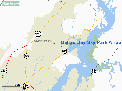
Dallas Bay Sky Park Airport |
Coordinates: 35°11′15″N 085°10′40″W / 35.1875°N 85.17778°W / 35.1875; -85.17778
| Dallas Bay Skypark |
| IATA: none – ICAO: none – FAA LID: 1A0 |
| Summary |
| Airport type |
Public |
| Owner |
John F. Flewellen, Inc. |
| Serves |
Chattanooga, Tennessee |
| Location |
Hixson, Tennessee |
| Elevation AMSL |
690 ft / 210 m |
| Website |
www.flydallasbay.com |
| Runways |
| Direction |
Length |
Surface |
| ft |
m |
| 5/23 |
3,025 |
922 |
Asphalt |
| Statistics (1998) |
| Aircraft operations |
10,108 |
| Source: Federal Aviation Administration |
Dallas Bay Skypark (FAA LID: 1A0) is a public-use airport located 11 miles (18 km) north of the central business district of Chattanooga, in Hixson, Hamilton County, Tennessee, United States. HistoryDallas Bay Skypark began life as the Optimist Club Drag Strip back in the late 50s and survived until the early 60s. The dragstrip was moved to East Ridge and John Flewellen and his family bought the old dragstrip and turned it into a private runway. In the early 1970s the airstrip became an FAA-certified public airport with the designation 1A0.
In 2002, a group of investors, all with a passion for flying, bought Dallas Bay Skypark and have been running it ever since. The airport is still a full-service public airport with a flight school on premises.
Facilities and aircraft
Dallas Bay Skypark covers an area of 60 acres (24 ha) which contains one asphalt paved runway (5/23) measuring 3,025 x 50 ft (922 x 15 m). For the 12-month period ending May 4, 1998, the airport had 10,108 aircraft operations, 100% of which were general aviation.
The above content comes from Wikipedia and is published under free licenses – click here to read more.
Location & QuickFacts
| FAA Information Effective: | 2008-09-25 |
| Airport Identifier: | 1A0 |
| Airport Status: | Operational |
| Longitude/Latitude: | 085-10-39.8410W/35-11-15.2540N
-85.177734/35.187571 (Estimated) |
| Elevation: | 690 ft / 210.31 m (Estimated) |
| Land: | 60 acres |
| From nearest city: | 11 nautical miles N of Chattanooga, TN |
| Location: | Hamilton County, TN |
| Magnetic Variation: | 02W (1985) |
Owner & Manager
| Ownership: | Privately owned |
| Owner: | John F. Flewellen, Inc |
| Address: | 1824 East Crabtree Rd.
Hixson, TN 37343 |
| Phone number: | 423-842-9845 |
| Manager: | David W. Flewellen |
| Address: | 1824 East Crabtree Rd.
Hixson, TN 37343 |
| Phone number: | 423-842-9845 |
Airport Operations and Facilities
| Airport Use: | Open to public |
| Wind indicator: | Yes |
| Segmented Circle: | No |
| Control Tower: | No |
| Lighting Schedule: | RDO-CTL
ACTVT LIRL RY 05/23 & ROTG BCN - 123.0. |
| Beacon Color: | Clear-Green (lighted land airport) |
| Landing fee charge: | No |
| Sectional chart: | Atlanta |
| Region: | ASO - Southern |
| Boundary ARTCC: | ZTL - Atlanta |
| Tie-in FSS: | BNA - Nashville |
| FSS on Airport: | No |
| FSS Toll Free: | 1-800-WX-BRIEF |
| NOTAMs Facility: | BNA (NOTAM-d service avaliable) |
Airport Communications
| CTAF: | 123.000 |
| Unicom: | 123.000 |
Airport Services
| Fuel available: | 100LL |
| Airframe Repair: | MAJOR |
| Power Plant Repair: | MAJOR |
Runway Information
Runway 05/23
| Dimension: | 3025 x 50 ft / 922.0 x 15.2 m |
| Surface: | ASPH, Fair Condition |
| Edge Lights: | Low |
| |
Runway 05 |
Runway 23 |
| Traffic Pattern: | Left | Right |
| Markings: | Basic, Poor Condition | Basic, Poor Condition |
| Displaced threshold: | 200.00 ft | 700.00 ft |
| Obstruction: | 72 ft tree, 650.0 ft from runway, 102 ft left of centerline, 6:1 slope to clear
APCH RATIO 11:1 TO DSPLCD THLD. | 44 ft trees, 350.0 ft from runway, 139 ft left of centerline, 3:1 slope to clear
APCH RATIO 23:1 TO DSPLCD THLD.
+4 FT FENCE & +15 FT ROAD 10 FT FM END OF PAVEMENT. |
|
Radio Navigation Aids
| ID |
Type |
Name |
Ch |
Freq |
Var |
Dist |
| CQN | NDB | Daisy | | 341.00 | 02W | 1.6 nm |
| HDI | NDB | Hardwick | | 369.00 | 01W | 13.5 nm |
| APT | NDB | Jasper | | 382.00 | 02W | 21.4 nm |
| DTE | NDB | Mark Anton | | 394.00 | 02W | 21.4 nm |
| UWI | NDB | Whitfield | | 400.00 | 03W | 26.5 nm |
| MMI | NDB | Mc Minn County | | 242.00 | 03W | 32.7 nm |
| UOS | NDB | Sewanee | | 275.00 | 02E | 35.3 nm |
| BGF | NDB | Boiling Fork | | 263.00 | 02W | 43.7 nm |
| RN | NDB | Warri | | 209.00 | 02W | 44.5 nm |
| MNV | NDB | Madisonville | | 361.00 | 04W | 44.5 nm |
| FTP | NDB | Fort Payne | | 426.00 | 01W | 46.9 nm |
| OUK | NDB | Calhoun | | 323.00 | 02W | 48.8 nm |
| GQO | VORTAC | Choo Choo | 105X | 115.80 | 01E | 13.7 nm |
| HCH | VORTAC | Hinch Mountain | 123X | 117.60 | 02W | 37.0 nm |
Remarks
- TREES BOTH SIDES OF RY VIOLATE 7:1 TRANSITIONAL SFC.
- BLDG PENETRATES PRIMARY SFC; N END OF RY BOTH SIDES.
Images and information placed above are from
http://www.airport-data.com/airport/1A0/
We thank them for the data!
| General Info
|
| Country |
United States
|
| State |
TENNESSEE
|
| FAA ID |
1A0
|
| Latitude |
35-11-15.254N
|
| Longitude |
085-10-39.841W
|
| Elevation |
690 feet
|
| Near City |
CHATTANOOGA
|
We don't guarantee the information is fresh and accurate. The data may
be wrong or outdated.
For more up-to-date information please refer to other sources.
|
|


