 |
|
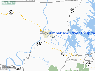
Cumberland River Hospital Heliport |
Location & QuickFacts
| FAA Information Effective: | 2008-09-25 |
| Airport Identifier: | TN45 |
| Airport Status: | Operational |
| Longitude/Latitude: | 085-30-01.8890W/36-32-40.2200N
-85.500525/36.544506 (Estimated) |
| Elevation: | 600 ft / 182.88 m (Estimated) |
| Land: | 0 acres |
| From nearest city: | 5 nautical miles E of Celina, TN |
| Location: | Clay County, TN |
| Magnetic Variation: | 01W (1985) |
Owner & Manager
| Ownership: | Privately owned |
| Owner: | Restoration Health Care Of Celina,
D/B/A CUMBERLAND RIVER HOSPITAL |
| Address: | D/b/a Cumberland River Hospital, 100 Old Jefferson St.
Celina, TN 38551 |
| Phone number: | 615-243-3581 |
| Manager: | Restoration Health Care Of Celina, |
| Address: | D/b/a Cumberland River Hospital, 100 Old Jefferson St.
Celina, TN 38551 |
| Phone number: | 615-243-3581 |
Airport Operations and Facilities
| Airport Use: | Private
MEDICAL USE. |
| Wind indicator: | Yes |
| Segmented Circle: | No |
| Control Tower: | No |
| Lighting Schedule: | PHONE REQ
FOR PERIMETER LIGHTS CALL 615-243-3581. |
| Sectional chart: | Memphis |
| Region: | ASO - Southern |
| Boundary ARTCC: | ZME - Memphis |
| Tie-in FSS: | BNA - Nashville |
| FSS Toll Free: | 1-800-WX-BRIEF |
Runway Information
Helipad H1
| Dimension: | 44 x 44 ft / 13.4 x 13.4 m |
| Surface: | CONC, |
| |
Runway H1 |
Runway |
| Traffic Pattern: | Left | Left |
|
Radio Navigation Aids
| ID |
Type |
Name |
Ch |
Freq |
Var |
Dist |
| LFB | NDB | Lafayette | | 245.00 | 02W | 27.1 nm |
| HEM | NDB | Huchn | | 233.00 | 02W | 33.7 nm |
| EKQ | NDB | Elk Spring | | 290.00 | 03W | 36.4 nm |
| SKN | NDB | Hurricane | | 256.00 | 02W | 36.8 nm |
| BVQ | NDB | Beaver Creek | | 260.00 | 02W | 37.5 nm |
| JUE | NDB | Lebanon | | 414.00 | 02W | 44.7 nm |
| CDX | NDB | Cumberland River | | 388.00 | 05E | 47.9 nm |
| RN | NDB | Warri | | 209.00 | 02W | 49.3 nm |
| BPO | NDB | Piney Grove | | 403.00 | 05W | 49.5 nm |
| LVT | VORTAC | Livingston | 021X | 108.40 | 02W | 16.3 nm |
Remarks
- VFR, PRIVATE USE; INGRESS ROUTES BE A 40 DEGS & 110 DEGS & EGRESS ROUTES AT 220 DEGS & 290 DEGS.
Images and information placed above are from
http://www.airport-data.com/airport/TN45/
We thank them for the data!
| General Info
|
| Country |
United States
|
| State |
TENNESSEE
|
| FAA ID |
TN45
|
| Latitude |
36-32-40.220N
|
| Longitude |
085-30-01.889W
|
| Elevation |
600 feet
|
| Near City |
CELINA
|
We don't guarantee the information is fresh and accurate. The data may
be wrong or outdated.
For more up-to-date information please refer to other sources.
|
|


