 |
|
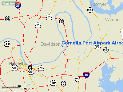
Cornelia Fort Airpark Airport |
Location & QuickFacts
| FAA Information Effective: | 2008-09-25 |
| Airport Identifier: | M88 |
| Airport Status: | Operational |
| Longitude/Latitude: | 086-41-58.9890W/36-11-25.2000N
-86.699719/36.190333 (Estimated) |
| Elevation: | 418 ft / 127.41 m (Surveyed) |
| Land: | 300 acres |
| From nearest city: | 5 nautical miles NE of Nashville, TN |
| Location: | Davidson County, TN |
| Magnetic Variation: | 01W (1985) |
Owner & Manager
| Ownership: | Privately owned |
| Owner: | Colemill Enterprises |
| Address: | Po Box 60627
Nashville, TN 37206 |
| Phone number: | 615-226-4256 |
| Manager: | Bill N. Colbert, Jr. |
| Address: | Po Box 60627
Nashville, TN 37206 |
| Phone number: | 615-226-4256 |
Airport Operations and Facilities
| Airport Use: | Open to public |
| Wind indicator: | Yes |
| Segmented Circle: | No |
| Control Tower: | No |
| Lighting Schedule: | DUSK-DAWN |
| Landing fee charge: | No |
| Sectional chart: | St Louis |
| Region: | ASO - Southern |
| Traffic Pattern Alt: | 582 ft |
| Boundary ARTCC: | ZME - Memphis |
| Tie-in FSS: | BNA - Nashville |
| FSS on Airport: | No |
| FSS Toll Free: | 1-800-WX-BRIEF |
| NOTAMs Facility: | BNA (NOTAM-d service avaliable) |
Airport Communications
| CTAF: | 123.075 |
| Unicom: | 123.075 |
Airport Services
| Fuel available: | 100LLA |
| Airframe Repair: | MAJOR |
| Power Plant Repair: | MAJOR |
| Bottled Oxygen: | LOW |
| Bulk Oxygen: | LOW |
Runway Information
Runway 04/22
| Dimension: | 3500 x 50 ft / 1066.8 x 15.2 m |
| Surface: | ASPH, Good Condition |
| Edge Lights: | Non-standard lighting system
RY 04/22 NSTD MIRL - NSTD HGT & THLD LGT LCTN. |
| |
Runway 04 |
Runway 22 |
| Traffic Pattern: | Right | Left |
| Markings: | Basic, Good Condition | Basic, Fair Condition |
| Obstruction: | 99 ft tree, 1683.0 ft from runway, 52 ft right of centerline, 15:1 slope to clear | 25 ft tree, 666.0 ft from runway, 21 ft right of centerline, 18:1 slope to clear |
|
Radio Navigation Aids
| ID |
Type |
Name |
Ch |
Freq |
Var |
Dist |
| SYI | FAN MARKER | Bomar | | | 01W | 44.0 nm |
| VI | NDB | Opery | | 344.00 | 02W | 2.4 nm |
| SWZ | NDB | Sewart | | 391.00 | 02W | 18.1 nm |
| JUE | NDB | Lebanon | | 414.00 | 02W | 18.7 nm |
| ON | NDB | Music | | 279.00 | 03W | 21.1 nm |
| FQW | NDB | Walter Hill | | 371.00 | 02W | 21.1 nm |
| PED | NDB | Needmore | | 221.00 | 01W | 23.3 nm |
| DMZ | NDB | Dickson | | 203.00 | 01W | 35.8 nm |
| LFB | NDB | Lafayette | | 245.00 | 02W | 36.6 nm |
| PBC | NDB | Maury County | | 365.00 | 01W | 39.8 nm |
| LUG | NDB | Verona | | 251.00 | 00W | 41.8 nm |
| SKN | NDB | Hurricane | | 256.00 | 02W | 45.0 nm |
| FK | NDB | Airbe | | 273.00 | 01W | 47.7 nm |
| ULH | NDB | Burwi | | 332.00 | 03W | 49.2 nm |
| HXW | TACAN | Screaming Eagle | 096X | | 01W | 48.3 nm |
| SYI | VOR/DME | Shelbyville | 027X | 109.00 | 01W | 39.8 nm |
| CKV | VOR/DME | Clarksville | 043X | 110.60 | 01W | 43.2 nm |
| BNA | VORTAC | Nashville | 088X | 114.10 | 02W | 3.3 nm |
| GHM | VORTAC | Graham | 053X | 111.60 | 03E | 42.4 nm |
| BWG | VORTAC | Bowling Green | 126X | 117.90 | 02E | 46.1 nm |
| BNA | VOT | Nashville Metropoln | | 108.60 | | 3.9 nm |
| MQY | VOT | Smyrna | | 110.20 | | 14.4 nm |
Remarks
- ENTER RIGHT TFC PAT RY 04 FM NW AT 1100 FT MSL; CTC NASHVILLE APCH CTL TO AVOID NASHVILLE INTL TFC.
- DEP TFC PAT RY 04 WEST TO NORTH; OTHERWISE CTC NASHVILLE APCH CTL FOR CLNC THRU AREA.
- ENTER LEFT TFC PAT FOR RY 22 FM NW AT 1100 FT MSL; CTC NASHVILLE APCH CTL TO AVOID NASHVILLE INTL TFC.
- DEP TFC PAT RY 22 TO THE WEST TO NORTH; OTHERWISE CTC NASHVILLE APCH CTL FOR CLNC THRU AREA.
- NO REQUEST
Images and information placed above are from
http://www.airport-data.com/airport/M88/
We thank them for the data!
| General Info
|
| Country |
United States
|
| State |
TENNESSEE
|
| FAA ID |
M88
|
| Latitude |
36-11-25.200N
|
| Longitude |
086-41-58.989W
|
| Elevation |
418 feet
|
| Near City |
NASHVILLE
|
We don't guarantee the information is fresh and accurate. The data may
be wrong or outdated.
For more up-to-date information please refer to other sources.
|
|


