 |
|
Collegedale Municipal Airport
Linn Field |
| IATA: none – ICAO: KFGU – FAA LID: FGU |
| Summary |
| Airport type |
Public |
| Owner |
City of Collegedale |
| Serves |
Collegedale, Tennessee |
| Elevation AMSL |
860 ft / 262 m |
| Coordinates |
35°02′35″N 085°01′19″W / 35.04306°N 85.02194°W / 35.04306; -85.02194 |
| Website |
CollegedaleTN.gov/... |
| Runways |
| Direction |
Length |
Surface |
| ft |
m |
| 3/21 |
4,700 |
1,433 |
Asphalt |
| Statistics (2008) |
| Aircraft operations |
22,525 |
| Based aircraft |
110 |
| Source: Federal Aviation Administration |
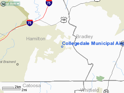
Collegedale Municipal Airport (ICAO: KFGU, FAA LID: FGU, formerly 3M3) is a city-owned, public-use airport located two nautical miles (3.7 km) southeast of the central business district of the City of Collegedale, in Hamilton County, Tennessee, United States.
Although most U.S. airports use the same three-letter location identifier for the FAA and IATA, this airport is assigned FGU by the FAA but has no designation from the IATA (which assigned FGU to Fangatau in French Polynesia).
The airport does not provide scheduled commercial service. However, charter service is provided by Aviation Specialists, Inc, a private company located at the airport, that offers flight instruction and a banner towing operation. Collegedale Municipal is one of the busiest general aviation airports in the state of Tennessee with an average of 120 aircraft stationed there. It won the Tennessee Aeronautics Commission's "Airport of the Year" award in 2003. History
Begun as a flying club in 1965 by pilot and mechanic John Linn and Ellsworth McKee—son of the founders of the McKee Foods Corporation, the Collegedale Airport was originally a 1,200-foot (370 m) grass strip on a farm. It was purchased by pilot-entrepreneur Aubrey Kinzer in 1969 and turned into a commercial venture with a flight school, rental aircraft, and aircraft maintenance. In 1972, the City of Collegedale obtained the property, and over the years the asphalt paved runway has been extended to 4,700 feet (1400 m) from its nominal 3,500-foot (1150 m) length and widened to 75 feet (23 m) with a parallel taxiway. In 1995, the airport was rededicated and renamed Linn Field in honor of John Linn. Renovations and additions to the terminal, lobby, and Fixed Base Operations (FBO) office were completed in 2003.
Facilities and aircraft
Collegedale Municipal Airport covers an area of 145 acres (59 ha) at an elevation of 860 feet (262 m) above mean sea level. It has one runway designated 3/21 with an asphalt surface measuring 4,700 by 75 feet (1,433 x 23 m).For the 12-month period ending October 20, 2008, the airport had 22,525 aircraft operations, an average of 61 per day: 98% general aviation and 2% air taxi. At that time there were 110 aircraft based at this airport: 90% single-engine, 3.6% multi-engine, 3.6% helicopter and 2.7% ultralight.
The airport offers rental and maintenance services and is open every day from 8:30 a.m. until dark, except for a half day on Christmas.
Nearby airports which have instrument procedures:
- CHA - Lovell Field 9 nautical miles (17 km) W
- HDI - Hardwick Field 14 nautical miles (26 km) NE
- DNN - Dalton Municipal Airport 21 nautical miles (39 km) S
- 9A5 - Barwick-LaFayette Airport 25 nautical miles (46 km) SW
- 2A0 - Mark Anton Airport 27 nautical miles (50 km) N
The above content comes from Wikipedia and is published under free licenses – click here to read more.
Location & QuickFacts
| FAA Information Effective: | 2008-09-25 |
| Airport Identifier: | 3M3 |
| Airport Status: | Operational |
| Longitude/Latitude: | 085-01-18.8150W/35-02-35.2690N
-85.021893/35.043130 (Estimated) |
| Elevation: | 860 ft / 262.13 m (Estimated) |
| Land: | 145 acres |
| From nearest city: | 2 nautical miles SE of Collegedale, TN |
| Location: | Hamilton County, TN |
| Magnetic Variation: | 02W (1985) |
Owner & Manager
| Ownership: | Publicly owned |
| Owner: | City Of Collegedale |
| Address: | 5100 Bess Moore Road
Collegedale, TN 37302 |
| Phone number: | 423-396-3135 |
| Manager: | Bill Rawson |
| Address: | 5100 Bess Moore Road
Collegedale, TN 37302 |
| Phone number: | 423-236-5008 |
Airport Operations and Facilities
| Airport Use: | Open to public |
| Wind indicator: | Yes |
| Segmented Circle: | Yes |
| Control Tower: | No |
| Lighting Schedule: | DUSK-DAWN |
| Beacon Color: | Clear-Green (lighted land airport) |
| Landing fee charge: | No |
| Sectional chart: | Atlanta |
| Region: | ASO - Southern |
| Traffic Pattern Alt: | 1040 ft |
| Boundary ARTCC: | ZTL - Atlanta |
| Tie-in FSS: | BNA - Nashville |
| FSS on Airport: | No |
| FSS Toll Free: | 1-800-WX-BRIEF |
| NOTAMs Facility: | BNA (NOTAM-d service avaliable) |
Airport Communications
| CTAF: | 122.700 |
| Unicom: | 122.700 |
Airport Services
| Fuel available: | 100LL |
| Airframe Repair: | MAJOR |
| Power Plant Repair: | MAJOR |
Runway Information
Runway 03/21
| Dimension: | 4700 x 75 ft / 1432.6 x 22.9 m |
| Surface: | ASPH, Good Condition |
| Edge Lights: | Medium |
| |
Runway 03 |
Runway 21 |
| Traffic Pattern: | Left | Left |
| Markings: | Non-precision instrument, Good Condition | Non-precision instrument, Good Condition |
| Crossing Height: | 0.00 ft | 35.00 ft |
| Displaced threshold: | 400.00 ft | 400.00 ft |
| VASI: | 2-box SAVASI on left side | 2-box SAVASI on left side |
| Visual Glide Angle: | 0.00° | 4.10° |
| Runway End Identifier: | No | Yes |
| Obstruction: | 45 ft trees, 700.0 ft from runway, 140 ft right of centerline, 11:1 slope to clear
APCH RATIO 24:1 FROM DSPLCD THLD. | 61 ft trees, 980.0 ft from runway, 7 ft left of centerline, 12:1 slope to clear
APCH RATIO 22:1 FROM DSPLCD THLD. |
|
Radio Navigation Aids
| ID |
Type |
Name |
Ch |
Freq |
Var |
Dist |
| HDI | NDB | Hardwick | | 369.00 | 01W | 8.8 nm |
| CQN | NDB | Daisy | | 341.00 | 02W | 10.0 nm |
| UWI | NDB | Whitfield | | 400.00 | 03W | 15.7 nm |
| DTE | NDB | Mark Anton | | 394.00 | 02W | 26.7 nm |
| APT | NDB | Jasper | | 382.00 | 02W | 27.7 nm |
| MMI | NDB | Mc Minn County | | 242.00 | 03W | 30.9 nm |
| OUK | NDB | Calhoun | | 323.00 | 02W | 38.9 nm |
| MNV | NDB | Madisonville | | 361.00 | 04W | 43.5 nm |
| UOS | NDB | Sewanee | | 275.00 | 02E | 44.0 nm |
| JZP | NDB | Pickens County | | 285.00 | 04W | 44.9 nm |
| FTP | NDB | Fort Payne | | 426.00 | 01W | 44.9 nm |
| OYD | NDB | Floyd | | 388.00 | 02W | 45.3 nm |
| GQO | VORTAC | Choo Choo | 105X | 115.80 | 01E | 8.1 nm |
| HCH | VORTAC | Hinch Mountain | 123X | 117.60 | 02W | 44.4 nm |
Remarks
- TREES & POWER LINE VIOLATE 7:1 TRANSITIONAL SFC R SIDE OF RY.
- VFR ONLY
Images and information placed above are from
http://www.airport-data.com/airport/3M3/
We thank them for the data!
| General Info
|
| Country |
United States
|
| State |
TENNESSEE
|
| FAA ID |
3M3
|
| Latitude |
35-02-35.269N
|
| Longitude |
085-01-18.815W
|
| Elevation |
860 feet
|
| Near City |
COLLEGEDALE
|
We don't guarantee the information is fresh and accurate. The data may
be wrong or outdated.
For more up-to-date information please refer to other sources.
|
|


