|
|
| Charles W. Baker Airport |
 |
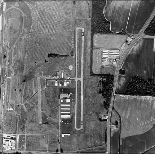
| Charles W. Baker from above |
| IATA: none – ICAO: none – FAA LID: 2M8 |
| Summary |
| Airport type |
Public |
| Owner |
Memphis - Shelby County Airport Authority |
| Serves |
Millington, TN |
| Location |
Shelby County, TN |
| Elevation AMSL |
247 ft / 75.3 m |
| Coordinates |
35°16′44.31″N 89°55′53.31″W / 35.278975°N 89.931475°W / 35.278975; -89.931475Coordinates: 35°16′44.31″N 89°55′53.31″W / 35.278975°N 89.931475°W / 35.278975; -89.931475 |
| Website |
http://www.charleswbakerairport.com/default.htm |
| Runways |
| Direction |
Length |
Surface |
| ft |
m |
| 18/36 |
3,500 |
1,066.8 |
Asphalt |
| 18U/36U |
1,600 |
487.7 |
Asphalt |
| Statistics (1997) |
| Operations |
39,600 |
| Based Aircraft |
110 |
| Source: FAA |
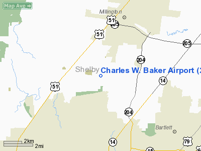
Charles W. Baker Airport (FAA LID: 2M8) is a civil, publicly-owned airport. It is located four miles (6 km) southwest of the central business district of Millington, TN, a city in Shelby County, Tennessee, United States. It is only 10 miles (16km) from downtown Memphis, TN. It is owned and operated by Memphis - Shelby County Airport Authority. It also immediately adjacent to Memphis Motorsports Park. History
Charles W. Baker Airport opened in 1949, and has also been known in the past as "Shelby County Airport". <http://www.aviationreferencedesk.com/airport/2M8/>
Facilities and aircraft
Charles W. Baker Airport is on a 259-acre (1.05 km) plot of land. It has an asphalt runway 18/36 that is 3,500 x 75 feet (1,066.8 x 28.7 meters)and handles up to 25,000 lb (11,000 kg). It has an additional asphalt runway 18U/36U designed solely for ultra-light aircraft that is 1,600 x 75 feet (487.7 x 28.7 m).
Charles W. Baker airport offers 100LL and JetA fuels from its FBO. Charles W Baker has a terminal that includes a pilot's lounge and a meeting room. The FBO also provides access to car rental via Enterprise Rent-A-Car.
Airlines and destinations
Shelby Charters is based out of Charles W Baker airport. They transport both passengers and cargo on demand. They have two Beech 55’s and a Cessna C-401A.
Other traffic includes ultra-light aircraft and general aviation aircraft.
No regular service operates to or from Charles W. Baker Airport.
The above content comes from Wikipedia and is published under free licenses – click here to read more.
 |
(Click on the photo to enlarge) |
Location & QuickFacts
| FAA Information Effective: | 2008-09-25 |
| Airport Identifier: | 2M8 |
| Airport Status: | Operational |
| Longitude/Latitude: | 089-55-53.3140W/35-16-44.3130N
-89.931476/35.278976 (Estimated) |
| Elevation: | 247 ft / 75.29 m (Surveyed) |
| Land: | 259 acres |
| From nearest city: | 4 nautical miles SW of Millington, TN |
| Location: | Shelby County, TN |
| Magnetic Variation: | 02E (1985) |
Owner & Manager
| Ownership: | Publicly owned |
| Owner: | Memphis Shelby Co Arpt Auth |
| Address: | Po Box 30168
Memphis, TN 38130 |
| Phone number: | 901-922-8000 |
| Manager: | Walter Cathey |
| Address: | 3870 Fite Road
Millington, TN 38053 |
| Phone number: | 901-873-1768 |
Airport Operations and Facilities
| Airport Use: | Open to public |
| Wind indicator: | Yes |
| Segmented Circle: | Yes |
| Control Tower: | No |
| Lighting Schedule: | DUSK-DAWN |
| Beacon Color: | Clear-Green (lighted land airport) |
| Landing fee charge: | No |
| Sectional chart: | Memphis |
| Region: | ASO - Southern |
| Boundary ARTCC: | ZME - Memphis |
| Tie-in FSS: | MKL - Jackson |
| FSS on Airport: | No |
| FSS Toll Free: | 1-800-WX-BRIEF |
| NOTAMs Facility: | MKL (NOTAM-d service avaliable) |
| Federal Agreements: | NGPY |
Airport Communications
| CTAF: | 122.800 |
| Unicom: | 122.800 |
Airport Services
| Fuel available: | 100LL |
| Airframe Repair: | MAJOR |
| Power Plant Repair: | MAJOR |
| Bottled Oxygen: | NONE |
| Bulk Oxygen: | NONE |
Runway Information
Runway 18/36
| Dimension: | 3500 x 75 ft / 1066.8 x 22.9 m |
| Surface: | ASPH, Fair Condition |
| Weight Limit: | Single wheel: 25000 lbs. |
| Edge Lights: | Medium |
| |
Runway 18 |
Runway 36 |
| Longitude: | 089-55-51.4830W | 089-55-54.7350W |
| Latitude: | 35-17-01.7790N | 35-16-27.2790N |
| Elevation: | 247.00 ft | 242.00 ft |
| Alignment: | 127 | 4 |
| Traffic Pattern: | Left | Right |
| Markings: | Basic, Fair Condition | Basic, Fair Condition |
| Crossing Height: | 40.00 ft | 40.00 ft |
| VASI: | 2-light PAPI on left side | 2-light PAPI on left side |
| Visual Glide Angle: | 4.00° | 4.00° |
| Runway End Identifier: | Yes | Yes |
| Centerline Lights: | No | No |
| Touchdown Lights: | No | No |
| Obstruction: | 117 ft tree, 2500.0 ft from runway, 70 ft left of centerline, 19:1 slope to clear | 85 ft tree, 1000.0 ft from runway, 212 ft left of centerline, 9:1 slope to clear |
|
Runway 18U/36U
| Dimension: | 1600 x 75 ft / 487.7 x 22.9 m |
| Surface: | ASPH, Fair Condition |
| Weight Limit: | Single wheel: 4000 lbs. |
| |
Runway 18U |
Runway 36U |
| Traffic Pattern: | Left | Left |
| Markings: | Nonstandard, Poor Condition
18U/36U NRS & CNTRLN STRIPES ONLY; MARKINGS FADED. | Nonstandard, Poor Condition |
| Runway End Identifier: | No | No |
| Centerline Lights: | No | No |
| Touchdown Lights: | No | No |
| Obstruction: | 30 ft tree, 475.0 ft from runway, 87 ft right of centerline, 9:1 slope to clear | 96 ft trees, 1500.0 ft from runway, 217 ft left of centerline, 13:1 slope to clear |
|
Radio Navigation Aids
| ID |
Type |
Name |
Ch |
Freq |
Var |
Dist |
| SPQ | NDB | Spain | | 414.00 | 04E | 7.5 nm |
| ME | NDB | Elvis | | 287.00 | 01E | 14.8 nm |
| AWM | NDB | West Memphis | | 362.00 | 01E | 17.0 nm |
| OLV | NDB | Olive Branch | | 275.00 | 01E | 19.3 nm |
| COO | NDB | Covington | | 326.00 | 02E | 25.2 nm |
| BPW | NDB | Osceola | | 239.00 | 02E | 25.2 nm |
| FYE | NDB | Somerville | | 255.00 | 00E | 26.8 nm |
| MXA | NDB | Manila | | 282.00 | 01E | 38.4 nm |
| IUI | NDB | Hicks | | 350.00 | 01E | 39.9 nm |
| BAV | NDB | Hardeman | | 404.00 | 01E | 43.8 nm |
| FCY | NDB | Forrest City | | 332.00 | 01E | 46.1 nm |
| GOJ | VOR | Gosnell | | 111.80 | 01E | 40.4 nm |
| GQE | VOR/DME | Gilmore | 077X | 113.00 | 04E | 27.1 nm |
| JBR | VOR/DME | Jonesboro | 023X | 108.60 | 02E | 48.1 nm |
| MEM | VORTAC | Memphis | 122X | 117.50 | 01E | 16.1 nm |
| HLI | VORTAC | Holly Springs | 071X | 112.40 | 03E | 37.3 nm |
| MEM | VOT | Memphis Metropolitn | | 111.00 | | 14.0 nm |
Remarks
- FIXED-WING TKOF/LNDG PROHIBITED FROM/TO GRASS AREAS.
- FUEL: JET A+
- VFR ONLY.
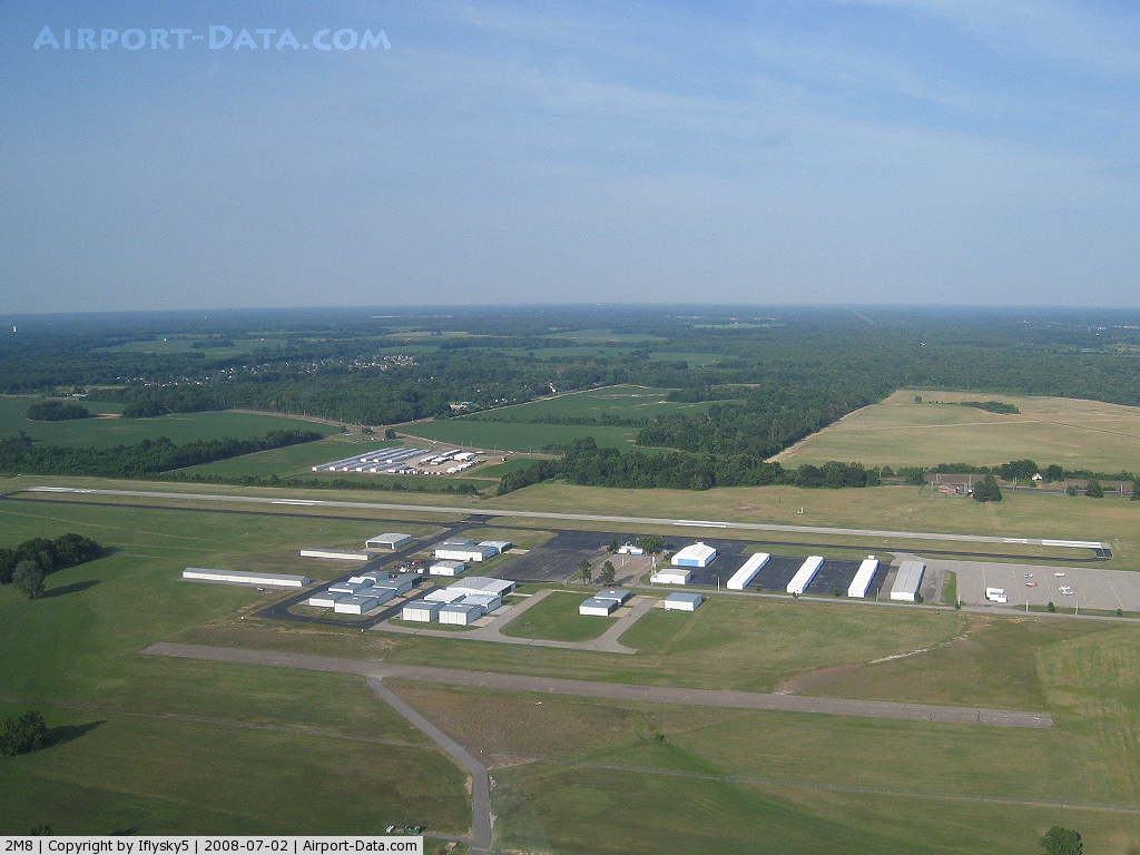
Images and information placed above are from
http://www.airport-data.com/airport/2M8/
We thank them for the data!
| General Info
|
| Country |
United States
|
| State |
TENNESSEE
|
| FAA ID |
2M8
|
| Latitude |
35-16-44.313N
|
| Longitude |
089-55-53.314W
|
| Elevation |
247 feet
|
| Near City |
MILLINGTON
|
We don't guarantee the information is fresh and accurate. The data may
be wrong or outdated.
For more up-to-date information please refer to other sources.
|
|