 |
|
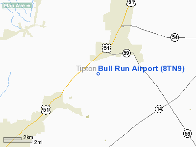
Location & QuickFacts
| FAA Information Effective: | 2008-09-25 |
| Airport Identifier: | 8TN9 |
| Airport Status: | Operational |
| Longitude/Latitude: | 089-40-40.0000W/35-30-56.0000N
-89.677778/35.515556 (Estimated) |
| Elevation: | 376 ft / 114.60 m (Estimated) |
| Land: | 3 acres |
| From nearest city: | 6 nautical miles NE of Covington, TN |
| Location: | Tipton County, TN |
| Magnetic Variation: | 01E (1995) |
Owner & Manager
| Ownership: | Privately owned |
| Owner: | Janes A. Bull, Jr |
| Address: | 1769 Old Memphis Road, P.o. Box 887
Covington, TN 38019-0887 |
| Phone number: | 901-476-1764
ADDL PHONE: 901-476-1764, FAX: 901-476-4602. |
| Manager: | James A. Bull, Jr |
| Address: | 1769 Old Memphis Road, P.o. Box 887
Covington, TN 38019-0887 |
| Phone number: | 901-476-1764
ADDL PHONE: 901-476-4601, FAX: 901-476-4602. |
Airport Operations and Facilities
| Airport Use: | Private |
| Wind indicator: | Yes |
| Segmented Circle: | No |
| Control Tower: | No |
| Sectional chart: | St Louis |
| Region: | ASO - Southern |
| Boundary ARTCC: | ZME - Memphis |
| Tie-in FSS: | MKL - Jackson |
| FSS Toll Free: | 1-800-WX-BRIEF |
Runway Information
Runway 06/24
| Dimension: | 1716 x 60 ft / 523.0 x 18.3 m |
| Surface: | TURF, |
| |
Runway 06 |
Runway 24 |
| Traffic Pattern: | Right | Left |
| Obstruction: | | 40 ft pline, 40.0 ft from runway |
|
Radio Navigation Aids
| ID |
Type |
Name |
Ch |
Freq |
Var |
Dist |
| COO | NDB | Covington | | 326.00 | 02E | 6.3 nm |
| MIG | NDB | Millington | | 232.00 | 04E | 18.9 nm |
| BPW | NDB | Osceola | | 239.00 | 02E | 19.5 nm |
| FYE | NDB | Somerville | | 255.00 | 00E | 23.3 nm |
| SPQ | NDB | Spain | | 414.00 | 04E | 26.3 nm |
| IUI | NDB | Hicks | | 350.00 | 01E | 26.5 nm |
| DNT | NDB | Nally Dunston | | 343.00 | 01W | 31.7 nm |
| MXA | NDB | Manila | | 282.00 | 01E | 32.5 nm |
| OLV | NDB | Olive Branch | | 275.00 | 01E | 32.7 nm |
| ME | NDB | Elvis | | 287.00 | 01E | 33.4 nm |
| AWM | NDB | West Memphis | | 362.00 | 01E | 35.4 nm |
| BAV | NDB | Hardeman | | 404.00 | 01E | 36.0 nm |
| TKX | NDB | Kennett | | 358.00 | 00E | 46.3 nm |
| TGC | NDB | Gibson | | 378.00 | 01E | 47.6 nm |
| GOJ | VOR | Gosnell | | 111.80 | 01E | 29.2 nm |
| MKL | VOR/DME | Mc Kellar | 057X | 112.00 | 02E | 37.9 nm |
| GQE | VOR/DME | Gilmore | 077X | 113.00 | 04E | 40.5 nm |
| JBR | VOR/DME | Jonesboro | 023X | 108.60 | 02E | 49.4 nm |
| MEM | VORTAC | Memphis | 122X | 117.50 | 01E | 33.6 nm |
| DYR | VORTAC | Dyersburg | 115X | 116.80 | 03E | 35.0 nm |
| HLI | VORTAC | Holly Springs | 071X | 112.40 | 03E | 45.7 nm |
| MEM | VOT | Memphis Metropolitn | | 111.00 | | 31.7 nm |
Remarks
- 300 FT WATER TOWER 3 NM NORTH OF ARPT.
- PRVDD OPNL LETTER OF AGREEMENT WITH BASKIN ARPT, ALL TFC PATS SOUTH OF ARPT.
Images and information placed above are from
http://www.airport-data.com/airport/8TN9/
We thank them for the data!
| General Info
|
| Country |
United States
|
| State |
TENNESSEE
|
| FAA ID |
8TN9
|
| Latitude |
35-30-56.000N
|
| Longitude |
089-40-40.000W
|
| Elevation |
376 feet
|
| Near City |
COVINGTON
|
We don't guarantee the information is fresh and accurate. The data may
be wrong or outdated.
For more up-to-date information please refer to other sources.
|
|


