 |
|
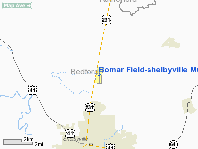
Bomar Field-shelbyville Muni Airport |
Coordinates: 35°33′34″N 086°26′33″W / 35.55944°N 86.4425°W / 35.55944; -86.4425
Shelbyville Municipal Airport
Bomar Field |
| IATA: SYI – ICAO: KSYI – FAA LID: SYI |
| Summary |
| Airport type |
Public |
| Owner |
City of Shelbyville |
| Serves |
Shelbyville, Tennessee |
| Elevation AMSL |
801 ft / 244 m |
| Runways |
| Direction |
Length |
Surface |
| ft |
m |
| 18/36 |
5,503 |
1,677 |
Asphalt |
| Statistics (2004) |
| Aircraft operations |
38,000 |
| Based aircraft |
52 |
| Source: Federal Aviation Administration |
Shelbyville Municipal Airport (IATA: SYI, ICAO: KSYI, FAA LID: SYI), also known as Bomar Field, is a city-owned public-use airport located four miles (6 km) north of the central business district of Shelbyville, a city in Bedford County, Tennessee, United States.
Facilities and aircraft
Shelbyville Municipal Airport covers an area of 604 acres (244 ha) and contains one asphalt paved runway designated 18/36 which measures 5,503 x 100 ft (1,677 x 30 m). For the 12-month period ending October 26, 2004, the airport had 38,000 aircraft operations, an average of 104 per day: 98% general aviation, 2% air taxi and <1% military. There are 52 aircraft based at this airport: 92% single-engine, 2% multi-engine, 4% helicopter and 2% ultralight.
The above content comes from Wikipedia and is published under free licenses – click here to read more.
Location & QuickFacts
| FAA Information Effective: | 2008-09-25 |
| Airport Identifier: | SYI |
| Airport Status: | Operational |
| Longitude/Latitude: | 086-26-32.9000W/35-33-33.8000N
-86.442472/35.559389 (Estimated) |
| Elevation: | 801 ft / 244.14 m (Surveyed) |
| Land: | 604 acres |
| From nearest city: | 4 nautical miles N of Shelbyville, TN |
| Location: | Bedford County, TN |
| Magnetic Variation: | 01W (1985) |
Owner & Manager
| Ownership: | Publicly owned |
| Owner: | City Of Shelbyville |
| Address: | City Hall Po Box185
Shelbyville, TN 37160 |
| Phone number: | 931-684-2691 |
| Manager: | Hank Williamson |
| Address: | 2828 Highway 231n
Shelbyville, TN 37160 |
| Phone number: | 931-684-1669 |
Airport Operations and Facilities
| Airport Use: | Open to public |
| Wind indicator: | Yes |
| Segmented Circle: | Yes |
| Control Tower: | No |
| Lighting Schedule: | DUSK-DAWN
MIRL RY 18/36 PRESET LOW INTST; TO INCREASE INTST ACTVT - CTAF. |
| Beacon Color: | Clear-Green (lighted land airport) |
| Landing fee charge: | No |
| Sectional chart: | Atlanta |
| Region: | ASO - Southern |
| Boundary ARTCC: | ZME - Memphis |
| Tie-in FSS: | BNA - Nashville |
| FSS on Airport: | No |
| FSS Toll Free: | 1-800-WX-BRIEF |
| NOTAMs Facility: | BNA (NOTAM-d service avaliable) |
| Federal Agreements: | NGY |
Airport Communications
| CTAF: | 122.800 |
| Unicom: | 122.800 |
Airport Services
| Fuel available: | 100LLA+ |
| Airframe Repair: | MAJOR |
| Power Plant Repair: | MAJOR |
| Bottled Oxygen: | NONE |
| Bulk Oxygen: | NONE |
Runway Information
Runway 18/36
| Dimension: | 5503 x 100 ft / 1677.3 x 30.5 m |
| Surface: | ASPH, Good Condition |
| Weight Limit: | Single wheel: 42000 lbs.
Dual wheel: 49000 lbs.
Dual tandem wheel: 75000 lbs. |
| Edge Lights: | Medium |
| |
Runway 18 |
Runway 36 |
| Longitude: | 086-26-33.2840W | 086-26-32.5363W |
| Latitude: | 35-34-01.0487N | 35-33-06.6307N |
| Elevation: | 799.00 ft | 793.00 ft |
| Alignment: | 127 | 127 |
| Traffic Pattern: | Left | Left |
| Markings: | Non-precision instrument, Good Condition | Non-precision instrument, Good Condition |
| Crossing Height: | 21.00 ft | 21.00 ft |
| VASI: | 4-light PAPI on left side | 4-light PAPI on left side |
| Visual Glide Angle: | 3.00° | 3.00° |
| Runway End Identifier: | Yes | Yes |
|
Radio Navigation Aids
| ID |
Type |
Name |
Ch |
Freq |
Var |
Dist |
| SYI | FAN MARKER | Bomar | | | 01W | 4.7 nm |
| ULH | NDB | Burwi | | 332.00 | 03W | 11.4 nm |
| LUG | NDB | Verona | | 251.00 | 00W | 18.3 nm |
| SWZ | NDB | Sewart | | 391.00 | 02W | 23.9 nm |
| FQW | NDB | Walter Hill | | 371.00 | 02W | 24.4 nm |
| TNY | NDB | Kelso | | 358.00 | 01W | 26.0 nm |
| BGF | NDB | Boiling Fork | | 263.00 | 02W | 29.4 nm |
| PBC | NDB | Maury County | | 365.00 | 01W | 31.9 nm |
| UOS | NDB | Sewanee | | 275.00 | 02E | 34.3 nm |
| RN | NDB | Warri | | 209.00 | 02W | 35.1 nm |
| JUE | NDB | Lebanon | | 414.00 | 02W | 38.5 nm |
| GZS | NDB | Giles/dcmsnd | | 375.00 | 00E | 38.9 nm |
| VI | NDB | Opery | | 344.00 | 02W | 40.1 nm |
| SKN | NDB | Hurricane | | 256.00 | 02W | 40.1 nm |
| LRT | NDB | Lawrenceburg | | 269.00 | 00E | 44.6 nm |
| HEM | NDB | Huchn | | 233.00 | 02W | 49.1 nm |
| UXM | VOR | Tullahoma Regional | | 109.65 | 03W | 14.4 nm |
| SYI | VOR/DME | Shelbyville | 027X | 109.00 | 01W | 0.2 nm |
| BNA | VORTAC | Nashville | 088X | 114.10 | 02W | 36.7 nm |
| RQZ | VORTAC | Rocket | 059X | 112.20 | 02E | 46.8 nm |
| MQY | VOT | Smyrna | | 110.20 | | 27.1 nm |
| BNA | VOT | Nashville Metropoln | | 108.60 | | 36.0 nm |
| HSV | VOT | Huntsville | | 111.00 | | 38.3 nm |
Images and information placed above are from
http://www.airport-data.com/airport/SYI/
We thank them for the data!
| General Info
|
| Country |
United States
|
| State |
TENNESSEE
|
| FAA ID |
SYI
|
| Latitude |
35-33-36.356N
|
| Longitude |
086-26-32.976W
|
| Elevation |
800 feet
|
| Near City |
SHELBYVILLE
|
We don't guarantee the information is fresh and accurate. The data may
be wrong or outdated.
For more up-to-date information please refer to other sources.
|
|


