 |
|
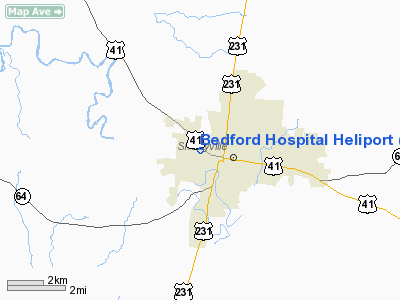
Bedford Hospital Heliport |
Location & QuickFacts
| FAA Information Effective: | 2008-09-25 |
| Airport Identifier: | TN15 |
| Airport Status: | Operational |
| Longitude/Latitude: | 086-28-23.9780W/35-29-35.2600N
-86.473327/35.493128 (Estimated) |
| Elevation: | 820 ft / 249.94 m (Estimated) |
| Land: | 0 acres |
| From nearest city: | 1 nautical miles NW of Shelbyville, TN |
| Location: | Bedford County, TN |
| Magnetic Variation: | 00E (1985) |
Owner & Manager
| Ownership: | Publicly owned |
| Owner: | Shelbyville Hospital Corporation |
| Address: | 845 Union St
Shelbyville, TN 37160 |
| Phone number: | 615-685-5143 |
| Manager: | Hospital Administrator |
| Address: | 845 Union St
Shelbyville, TN 37160 |
| Phone number: | 615-685-5143 |
Airport Operations and Facilities
| Airport Use: | Private
MEDICAL |
| Segmented Circle: | No |
| Control Tower: | No |
| Lighting Schedule: | PHONE REQ
PERIMETER LGTS CALL 615-684-3611. |
| Sectional chart: | Atlanta |
| Region: | ASO - Southern |
| Boundary ARTCC: | ZME - Memphis |
| Tie-in FSS: | BNA - Nashville |
| FSS Toll Free: | 1-800-WX-BRIEF |
Runway Information
Helipad H1
| Dimension: | 60 x 60 ft / 18.3 x 18.3 m |
| Surface: | CONC, |
| |
Runway H1 |
Runway |
| Traffic Pattern: | Left | Left |
|
Radio Navigation Aids
| ID |
Type |
Name |
Ch |
Freq |
Var |
Dist |
| SYI | FAN MARKER | Bomar | | | 01W | 0.7 nm |
| ULH | NDB | Burwi | | 332.00 | 03W | 11.5 nm |
| LUG | NDB | Verona | | 251.00 | 00W | 16.5 nm |
| TNY | NDB | Kelso | | 358.00 | 01W | 21.8 nm |
| BGF | NDB | Boiling Fork | | 263.00 | 02W | 27.4 nm |
| SWZ | NDB | Sewart | | 391.00 | 02W | 27.9 nm |
| FQW | NDB | Walter Hill | | 371.00 | 02W | 28.6 nm |
| PBC | NDB | Maury County | | 365.00 | 01W | 31.0 nm |
| UOS | NDB | Sewanee | | 275.00 | 02E | 33.2 nm |
| GZS | NDB | Giles/dcmsnd | | 375.00 | 00E | 35.3 nm |
| RN | NDB | Warri | | 209.00 | 02W | 38.0 nm |
| LRT | NDB | Lawrenceburg | | 269.00 | 00E | 41.6 nm |
| JUE | NDB | Lebanon | | 414.00 | 02W | 42.7 nm |
| VI | NDB | Opery | | 344.00 | 02W | 43.6 nm |
| SKN | NDB | Hurricane | | 256.00 | 02W | 43.9 nm |
| CWH | NDB | Capshaw | | 350.00 | 01W | 45.8 nm |
| HUA | NDB | Redstone | | 287.00 | 00W | 48.9 nm |
| UXM | VOR | Tullahoma Regional | | 109.65 | 03W | 13.0 nm |
| SYI | VOR/DME | Shelbyville | 027X | 109.00 | 01W | 4.5 nm |
| BNA | VORTAC | Nashville | 088X | 114.10 | 02W | 40.0 nm |
| RQZ | VORTAC | Rocket | 059X | 112.20 | 02E | 42.6 nm |
| MQY | VOT | Smyrna | | 110.20 | | 30.9 nm |
| HSV | VOT | Huntsville | | 111.00 | | 34.1 nm |
| BNA | VOT | Nashville Metropoln | | 108.60 | | 39.4 nm |
Remarks
- (E111-1) TREES UNDER 360 DEGS DEP ROUTE NORTH OF PAD TOPPED; RED OBSTNLGT PLACED ON AMBULANCE BLDG ANTENNA; AND PROC ESTAB THAT RCMD NO APCHS/DEP TO/FROM NORTH AND/OR NORTHEAST.
- PRVDD FR/PVT USE; PORTABLE FIRE EXTINGUISHER PRVDD; PROC IS ESTABD W/LOCAL FIRE DEPT TO INCLUDE FIRE SUPPRESSANT CHEMICALS; BOUNDARY FENCE BETWEEN PARKING LOST & HELIPAD AREA EXTDD.
Images and information placed above are from
http://www.airport-data.com/airport/TN15/
We thank them for the data!
| General Info
|
| Country |
United States
|
| State |
TENNESSEE
|
| FAA ID |
TN15
|
| Latitude |
35-29-35.260N
|
| Longitude |
086-28-23.978W
|
| Elevation |
820 feet
|
| Near City |
SHELBYVILLE
|
We don't guarantee the information is fresh and accurate. The data may
be wrong or outdated.
For more up-to-date information please refer to other sources.
|
|


