 |
|
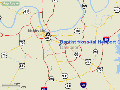
Baptist Hospital Heliport |
Location & QuickFacts
| FAA Information Effective: | 2008-09-25 |
| Airport Identifier: | 2TN6 |
| Airport Status: | Operational |
| Longitude/Latitude: | 086-44-19.9930W/36-08-15.2060N
-86.738887/36.137557 (Estimated) |
| Elevation: | 690 ft / 210.31 m (Estimated) |
| Land: | 0 acres |
| From nearest city: | 0 nautical miles E of Nashville, TN |
| Location: | Davidson County, TN |
| Magnetic Variation: | 00W (1985) |
Owner & Manager
| Ownership: | Privately owned |
| Owner: | Baptish Health Care Sys., Inc |
| Address: | 2000 Church St
Nashville, TN 37236 |
| Phone number: | 615-329-5555 |
| Manager: | Chris Riddle, Admin. Dir. |
| Address: | 2000 Church St
Nashville, TN 37236 |
| Phone number: | 615-329-6354 |
Airport Operations and Facilities
| Airport Use: | Private
MEDICAL. |
| Wind indicator: | Yes |
| Segmented Circle: | No |
| Control Tower: | No |
| Lighting Schedule: | DUSK-DAWN |
| Beacon Color: | Clear-Green-Yellow (heliport) |
| Sectional chart: | St Louis |
| Region: | ASO - Southern |
| Boundary ARTCC: | ZME - Memphis |
| Tie-in FSS: | BNA - Nashville |
| FSS Toll Free: | 1-800-WX-BRIEF |
Runway Information
Helipad H1
| Dimension: | 40 x 40 ft / 12.2 x 12.2 m |
| Surface: | CONC,
ROOFTOP. |
| |
Runway H1 |
Runway |
| Traffic Pattern: | Left | Left |
|
Radio Navigation Aids
| ID |
Type |
Name |
Ch |
Freq |
Var |
Dist |
| SYI | FAN MARKER | Bomar | | | 01W | 41.5 nm |
| VI | NDB | Opery | | 344.00 | 02W | 5.8 nm |
| SWZ | NDB | Sewart | | 391.00 | 02W | 17.2 nm |
| FQW | NDB | Walter Hill | | 371.00 | 02W | 20.8 nm |
| JUE | NDB | Lebanon | | 414.00 | 02W | 20.9 nm |
| ON | NDB | Music | | 279.00 | 03W | 22.4 nm |
| PED | NDB | Needmore | | 221.00 | 01W | 25.5 nm |
| DMZ | NDB | Dickson | | 203.00 | 01W | 33.7 nm |
| PBC | NDB | Maury County | | 365.00 | 01W | 36.2 nm |
| LUG | NDB | Verona | | 251.00 | 00W | 38.4 nm |
| LFB | NDB | Lafayette | | 245.00 | 02W | 39.9 nm |
| SKN | NDB | Hurricane | | 256.00 | 02W | 46.2 nm |
| ULH | NDB | Burwi | | 332.00 | 03W | 47.3 nm |
| FK | NDB | Airbe | | 273.00 | 01W | 48.6 nm |
| AEY | NDB | Waverly | | 329.00 | 00E | 48.7 nm |
| HXW | TACAN | Screaming Eagle | 096X | | 01W | 48.8 nm |
| SYI | VOR/DME | Shelbyville | 027X | 109.00 | 01W | 37.6 nm |
| CKV | VOR/DME | Clarksville | 043X | 110.60 | 01W | 43.7 nm |
| BNA | VORTAC | Nashville | 088X | 114.10 | 02W | 2.6 nm |
| GHM | VORTAC | Graham | 053X | 111.60 | 03E | 39.2 nm |
| BWG | VORTAC | Bowling Green | 126X | 117.90 | 02E | 49.7 nm |
| BNA | VOT | Nashville Metropoln | | 108.60 | | 2.8 nm |
| MQY | VOT | Smyrna | | 110.20 | | 13.7 nm |
Remarks
- PRVDD VFR/PVT USE ONLY; AIR COND UNITS ARE SECURED; GRVL IS SEALED & LGTS ARE AT PAD LEVEL.
Images and information placed above are from
http://www.airport-data.com/airport/2TN6/
We thank them for the data!
| General Info
|
| Country |
United States
|
| State |
TENNESSEE
|
| FAA ID |
2TN6
|
| Latitude |
36-08-15.206N
|
| Longitude |
086-44-19.993W
|
| Elevation |
690 feet
|
| Near City |
NASHVILLE
|
We don't guarantee the information is fresh and accurate. The data may
be wrong or outdated.
For more up-to-date information please refer to other sources.
|
|


