 |
|
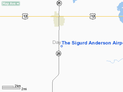
The Sigurd Anderson Airport |
Location & QuickFacts
| FAA Information Effective: | 2008-09-25 |
| Airport Identifier: | 1D7 |
| Airport Status: | Operational |
| Longitude/Latitude: | 097-30-49.6627W/45-17-33.3019N
-97.513795/45.292584 (Estimated) |
| Elevation: | 1854 ft / 565.10 m (Estimated) |
| Land: | 104 acres |
| From nearest city: | 2 nautical miles S of Webster, SD |
| Location: | Day County, SD |
| Magnetic Variation: | 07E (1985) |
Owner & Manager
| Ownership: | Publicly owned |
| Owner: | City Of Webster |
| Address: | Po Box 539
Webster, SD 57274 |
| Phone number: | 605-345-3241 |
| Manager: | Leroy Brown |
| Address: | 916 W. 7th Street
Webster, SD 57274 |
| Phone number: | 605-345-4197 |
Airport Operations and Facilities
| Airport Use: | Open to public |
| Wind indicator: | Yes |
| Segmented Circle: | Yes |
| Control Tower: | No |
| Lighting Schedule: | DUSK-DAWN
ACTVT LIRL RY 12/30 - CTAF. |
| Beacon Color: | Clear-Green (lighted land airport) |
| Sectional chart: | Twin Cities |
| Region: | AGL - Great Lakes |
| Boundary ARTCC: | ZMP - Minneapolis |
| Tie-in FSS: | HON - Huron |
| FSS Toll Free: | 1-800-WX-BRIEF |
| NOTAMs Facility: | HON (NOTAM-d service avaliable) |
| Federal Agreements: | NGY |
Airport Communications
Airport Services
Runway Information
Runway 01/19
| Dimension: | 2200 x 150 ft / 670.6 x 45.7 m |
| Surface: | TURF, Good Condition |
| |
Runway 01 |
Runway 19 |
| Longitude: | 097-31-04.1900W | 097-31-00.1700W |
| Latitude: | 45-17-15.4100N | 45-17-47.8700N |
| Elevation: | 1846.00 ft | 1854.00 ft |
| Traffic Pattern: | Left | Left |
| Runway End Identifier: | No | No |
| Centerline Lights: | No | No |
| Touchdown Lights: | No | No |
| Obstruction: | 5 ft fence, 100.0 ft from runway, 20:1 slope to clear | 22 ft trees, 450.0 ft from runway, 50 ft right of centerline, 20:1 slope to clear |
|
Runway 12/30
| Dimension: | 3700 x 60 ft / 1127.8 x 18.3 m |
| Surface: | ASPH, Fair Condition |
| Weight Limit: | Single wheel: 12500 lbs. |
| Edge Lights: | Low |
| |
Runway 12 |
Runway 30 |
| Longitude: | 097-31-03.9200W | 097-30-20.5200W |
| Latitude: | 45-17-44.2400N | 45-17-24.3400N |
| Elevation: | 1857.00 ft | 1845.00 ft |
| Alignment: | 123 | 127 |
| Traffic Pattern: | Left | Left |
| Markings: | Basic, Fair Condition | Basic, Fair Condition |
| Runway End Identifier: | No | No |
| Centerline Lights: | No | No |
| Touchdown Lights: | No | No |
| Obstruction: | 19 ft road, 600.0 ft from runway, 21:1 slope to clear | , 50:1 slope to clear |
|
Radio Navigation Aids
| ID |
Type |
Name |
Ch |
Freq |
Var |
Dist |
| BTN | NDB | Britton | | 386.00 | 06E | 33.1 nm |
| VVV | NDB | Ortonville | | 332.00 | 05E | 46.2 nm |
| ABR | VOR/DME | Aberdeen | 077X | 113.00 | 07E | 36.9 nm |
| ATY | VORTAC | Watertown | 113X | 116.60 | 09E | 24.5 nm |
Remarks
- RY 19 +4' FENCE 306' FM THR; 17 ROAD 340' FM THR.
- BIRDS AND WATERFOWL ON AND INVOF ARPT.
- 100LL FUEL UNAVBL.
- EXISTED PRIOR TO 1959.
Images and information placed above are from
http://www.airport-data.com/airport/1D7/
We thank them for the data!
| General Info
|
| Country |
United States
|
| State |
SOUTH DAKOTA
|
| FAA ID |
1D7
|
| Latitude |
45-17-35.848N
|
| Longitude |
097-30-49.316W
|
| Elevation |
1854 feet
|
| Near City |
WEBSTER
|
We don't guarantee the information is fresh and accurate. The data may
be wrong or outdated.
For more up-to-date information please refer to other sources.
|
|


