 |
|
| Rapid City Regional Airport |
 |
| IATA: RAP – ICAO: KRAP – FAA LID: RAP |
| Summary |
| Airport type |
Public |
| Owner |
City of Rapid City |
| Serves |
Rapid City, South Dakota |
| Elevation AMSL |
3,204 ft / 977 m |
| Coordinates |
44°02′43″N 103°03′26″W / 44.04528°N 103.05722°W / 44.04528; -103.05722 |
| Website |
RCgov.org/Airport/... |
| Runways |
| Direction |
Length |
Surface |
| ft |
m |
| 14/32 |
8,701 |
2,652 |
Concrete |
| 5/23 |
3,601 |
1,098 |
Asphalt |
| Statistics (2007) |
| Aircraft operations |
47,844 |
| Based aircraft |
125 |
| Source: Federal Aviation Administration |
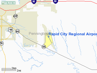
Rapid City Regional Airport (IATA: RAP, ICAO: KRAP, FAA LID: RAP) is a city-owned, public-use airport located eight nautical miles (15 km) southeast of the central business district of Rapid City, in Pennington County, South Dakota, United States. Facilities and aircraft
Rapid City Regional Airport covers an area of 1,655 acres (670 ha) at an elevation of 3,204 feet (977 m) above mean sea level. It has two runways: 14/32 is 8,701 by 150 feet (2,652 x 46 m) with a concrete surface and 5/23 is 3,601 by 75 feet (1,098 x 23 m) with an asphalt surface.
For the 12-month period ending December 31, 2007, the airport had 47,844 aircraft operations, an average of 131 per day: 60% general aviation, 26% air taxi, 8% military and 5% scheduled commercial. At that time there were 125 aircraft based at this airport: 64% single-engine, 22% multi-engine, 3% jet, 3% helicopter and 8% military.
Airlines and destinations
| Airlines |
Destinations |
| Allegiant Air |
Las Vegas, Phoenix/Mesa |
| American Eagle |
Chicago-O'Hare [seasonal], Dallas/Fort Worth |
| Delta Air Lines |
Minneapolis/St. Paul |
| Delta Connection operated by Mesaba Airlines |
Minneapolis/St. Paul |
| Delta Connection operated by SkyWest Airlines |
Salt Lake City, Minneapolis/St. Paul |
| United Airlines |
Chicago-O'Hare, Denver [all seasonal] |
| United Express operated by SkyWest Airlines |
Chicago-O'Hare, Denver |
The above content comes from Wikipedia and is published under free licenses – click here to read more.
Location & QuickFacts
| FAA Information Effective: | 2008-09-25 |
| Airport Identifier: | RAP |
| Airport Status: | Operational |
| Longitude/Latitude: | 103-03-26.5000W/44-02-43.2000N
-103.057361/44.045333 (Estimated) |
| Elevation: | 3204 ft / 976.58 m (Surveyed) |
| Land: | 1655 acres |
| From nearest city: | 8 nautical miles SE of Rapid City, SD |
| Location: | Pennington County, SD |
| Magnetic Variation: | 11E (1985) |
Owner & Manager
| Ownership: | Publicly owned |
| Owner: | City Of Rapid City |
| Address: | 4550 Terminal Rd - Ste 102
Rapid City, SD 57703 |
| Phone number: | 605-394-4110 |
| Manager: | Mason Short |
| Address: | 4550 Terminal Rd - Ste 102
Rapid City, SD 57703 |
| Phone number: | 605-394-4195 |
Airport Operations and Facilities
| Airport Use: | Open to public |
| Wind indicator: | Yes |
| Segmented Circle: | Yes |
| Control Tower: | Yes |
| Lighting Schedule: | DUSK-DAWN
WHEN ATCT CLSD ACTVT HIRL RY 14/32, MIRL RY 05/23, MALSR RY 32, PAPI RYS 05 & 23 14 & 32, REIL RY 14 & TWY 'A' & 'B' LGTS - CTAF. |
| Beacon Color: | Clear-Green (lighted land airport) |
| Landing fee charge: | No |
| Sectional chart: | Cheyenne |
| Region: | AGL - Great Lakes |
| Boundary ARTCC: | ZDV - Denver |
| Tie-in FSS: | HON - Huron |
| FSS on Airport: | No |
| FSS Toll Free: | 1-800-WX-BRIEF |
| NOTAMs Facility: | RAP (NOTAM-d service avaliable) |
| Certification type/date: | I B S 05/1973
RY 05/23 NOT AVBL FOR SCHED ACR OPNS WITH ACFT DESIGNED FOR 10+ PSGR SEATS, AND SCHED/UNSCHED ACR OPNS WITH ACFT DESIGNED FOR 31+ PSGR SEATS. ARFF INDEX "C" PPR, CALL AMGR 605-394-4195 OR 605-394-4185. |
| Federal Agreements: | NGY |
Airport Communications
| CTAF: | 125.850 |
| Unicom: | 122.950 |
Airport Services
| Fuel available: | 100LLA |
| Airframe Repair: | MAJOR |
| Power Plant Repair: | MAJOR |
| Bottled Oxygen: | NONE |
| Bulk Oxygen: | HIGH |
Runway Information
Runway 05/23
| Dimension: | 3601 x 75 ft / 1097.6 x 22.9 m |
| Surface: | ASPH, Good Condition |
| Weight Limit: | Single wheel: 12500 lbs. |
| Edge Lights: | Medium |
| |
Runway 05 |
Runway 23 |
| Longitude: | 103-03-49.7506W | 103-03-06.2874W |
| Latitude: | 44-02-52.3244N | 44-03-09.0830N |
| Elevation: | 3173.00 ft | 3204.00 ft |
| Alignment: | 62 | 127 |
| Traffic Pattern: | Right | Left |
| Markings: | Basic, Good Condition | Basic, Good Condition |
| Crossing Height: | 32.00 ft | 26.00 ft |
| VASI: | 4-light PAPI on left side | 4-light PAPI on left side |
| Visual Glide Angle: | 3.00° | 3.00° |
| Runway End Identifier: | No | No |
| Centerline Lights: | No | No |
| Touchdown Lights: | No | No |
| Obstruction: | , 50:1 slope to clear | 15 ft road, 628.0 ft from runway, 30:1 slope to clear
GND +1FT. 94FT. FM RWY END AND 115FT. L OF RWY C/L. |
|
Runway 14/32
| Dimension: | 8701 x 150 ft / 2652.1 x 45.7 m |
| Surface: | CONC, Good Condition |
| Surface Treatment: | Saw-cut or plastic Grooved |
| Weight Limit: | Single wheel: 140000 lbs.
Dual wheel: 190000 lbs.
Dual tandem wheel: 300000 lbs. |
| Edge Lights: | High |
| |
Runway 14 |
Runway 32 |
| Longitude: | 103-03-54.0275W | 103-02-57.8009W |
| Latitude: | 44-03-13.7830N | 44-01-58.0493N |
| Elevation: | 3191.00 ft | 3143.00 ft |
| Alignment: | 127 | 127 |
| ILS Type: | | ILS/DME
|
| Traffic Pattern: | Left | Left |
| Markings: | Precision instrument, Fair Condition | Precision instrument, Fair Condition |
| Crossing Height: | 47.00 ft | 54.00 ft |
| VASI: | 4-light PAPI on left side | 4-light PAPI on left side |
| Visual Glide Angle: | 3.00° | 3.00° |
| RVR Equipment: | | touchdown |
| Approach lights: | | MALSR |
| Runway End Identifier: | Yes | No |
| Centerline Lights: | No | No |
| Touchdown Lights: | No | No |
|
Radio Navigation Aids
| ID |
Type |
Name |
Ch |
Freq |
Var |
Dist |
| RA | NDB | Ranch | | 254.00 | 11E | 5.5 nm |
| SPF | NDB | Black Hills | | 300.00 | 11E | 40.9 nm |
| RCA | TACAN | Ellsworth | 025X | | 11E | 5.9 nm |
| RAP | VORTAC | Rapid City | 070X | 112.30 | 13E | 4.6 nm |
Remarks
- BIRDS ON & INVOF ARPT.
- TWR HAS LIMITED VISIBILITY OF TWY T1 AND TWY T2 AND TWY B AT AER RWY 23
- CTN: EXTENSIVE MILITARY JET TFC INVOF & NNW OF ARPT.
- LINE-OF-SIGHT IS RESTRICTED BETWEEN RY 14 & RY 23 PHYSICAL ENDS.
- 152 FT AGL TWR 2.5 NM NNW OF ARPT.
- BE ALERT DO NOT MISTAKE ELLSWORTH AFB, LOCATED 6.5 NM NNW FOR RAPID CITY RGNL.
Images and information placed above are from
http://www.airport-data.com/airport/RAP/
We thank them for the data!
| General Info
|
| Country |
United States
|
| State |
SOUTH DAKOTA
|
| FAA ID |
RAP
|
| Latitude |
44-02-43.200N
|
| Longitude |
103-03-26.500W
|
| Elevation |
3204 feet
|
| Near City |
RAPID CITY
|
We don't guarantee the information is fresh and accurate. The data may
be wrong or outdated.
For more up-to-date information please refer to other sources.
|
|


