 |
|
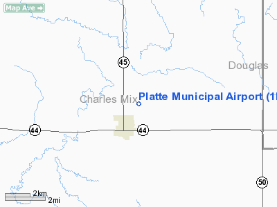
Location & QuickFacts
| FAA Information Effective: | 2008-09-25 |
| Airport Identifier: | 1D3 |
| Airport Status: | Operational |
| Longitude/Latitude: | 098-49-46.3070W/43-24-11.9820N
-98.829530/43.403328 (Estimated) |
| Elevation: | 1618 ft / 493.17 m (Surveyed) |
| Land: | 72 acres |
| From nearest city: | 1 nautical miles NE of Platte, SD |
| Location: | Charles Mix County, SD |
| Magnetic Variation: | 08E (1985) |
Owner & Manager
| Ownership: | Publicly owned |
| Owner: | City Of Platte |
| Address: | P O Box 236
Platte, SD 57369 |
| Phone number: | 605-337-3921 |
| Manager: | Doug Sly |
| Address: | P O Box 754
Platte, SD 57369 |
| Phone number: | 605-337-2334 |
Airport Operations and Facilities
| Airport Use: | Open to public |
| Wind indicator: | Yes |
| Segmented Circle: | Yes |
| Control Tower: | No |
| Lighting Schedule: | DUSK-DAWN
ACTVT LIRL RY 14/32 - CTAF. |
| Beacon Color: | Clear-Green (lighted land airport) |
| Landing fee charge: | No |
| Sectional chart: | Omaha |
| Region: | AGL - Great Lakes |
| Boundary ARTCC: | ZMP - Minneapolis |
| Tie-in FSS: | HON - Huron |
| FSS on Airport: | No |
| FSS Toll Free: | 1-800-WX-BRIEF |
| NOTAMs Facility: | HON (NOTAM-d service avaliable) |
| Federal Agreements: | NGY |
Airport Communications
| CTAF: | 122.800 |
| Unicom: | 122.800 |
Airport Services
| Airframe Repair: | MAJOR |
| Power Plant Repair: | MINOR |
| Bottled Oxygen: | NONE |
| Bulk Oxygen: | NONE |
Runway Information
Runway 14/32
| Dimension: | 3100 x 60 ft / 944.9 x 18.3 m |
| Surface: | ASPH, Fair Condition |
| Edge Lights: | Low |
| |
Runway 14 |
Runway 32 |
| Longitude: | 098-50-02.9100W | 098-49-39.3500W |
| Latitude: | 43-24-26.7700N | 43-24-03.8500N |
| Elevation: | 1600.00 ft | 1618.00 ft |
| Traffic Pattern: | Left | Right |
| Markings: | Basic, Fair Condition | Basic, Fair Condition |
| Obstruction: | 18 ft tree, 578.0 ft from runway, 20 ft right of centerline, 21:1 slope to clear | 46 ft trees, 1250.0 ft from runway, 10 ft left of centerline, 22:1 slope to clear |
|
Radio Navigation Aids
| ID |
Type |
Name |
Ch |
Freq |
Var |
Dist |
| AGZ | NDB | Wagner | | 392.00 | 08E | 31.2 nm |
| ISD | VOR | Winner | | 112.80 | 08E | 41.0 nm |
| MHE | VOR/DME | Mitchell | 029X | 109.20 | 07E | 41.1 nm |
Remarks
- DURING WINTER MONTHS RY COULD BE SLIPPERY; CFM WINTER CONDS WITH AMGR CALL (605) 337-2334/3923.
- DEER & OTHER WILDLIFE ON & INVOF ARPT.
Images and information placed above are from
http://www.airport-data.com/airport/1D3/
We thank them for the data!
| General Info
|
| Country |
United States
|
| State |
SOUTH DAKOTA
|
| FAA ID |
1D3
|
| Latitude |
43-24-11.982N
|
| Longitude |
098-49-46.307W
|
| Elevation |
1618 feet
|
| Near City |
PLATTE
|
We don't guarantee the information is fresh and accurate. The data may
be wrong or outdated.
For more up-to-date information please refer to other sources.
|
|


