|
|
| Pierre Regional Airport |
 |
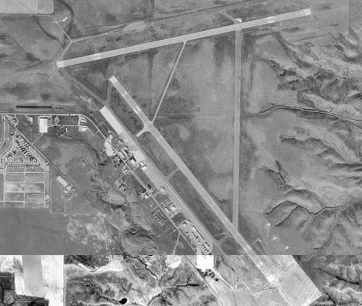
| 1996 USGS photo |
| IATA: PIR – ICAO: KPIR – FAA LID: PIR |
| Summary |
| Airport type |
City of Pierre |
| Operator |
Pierre, South Dakota |
| Location |
Pierre, South Dakota |
| Elevation AMSL |
1,742 ft / 531 m |
| Coordinates |
44°22′58″N 100°17′09″W / 44.38278°N 100.28583°W / 44.38278; -100.28583 |
| Runways |
| Direction |
Length |
Surface |
| ft |
m |
| 7/25 |
6,887 |
2,099 |
Asphalt |
| 13/31 |
6,900 |
2,103 |
Asphalt |
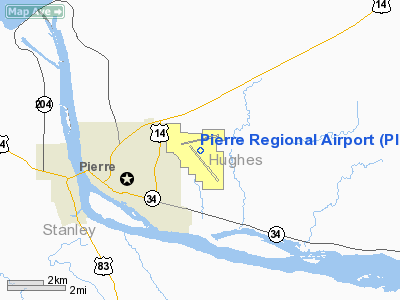
Pierre Regional Airport (IATA: PIR, ICAO: KPIR, FAA LID: PIR) is a public airport located three miles (5 km) east of the central business district (CBD) of Pierre, a city in Hughes County, South Dakota, USA. The airport covers 1,735 acres (702 ha) and has two runways. It is served by two commercial airlines.
Until June 30, 2006, service provided by Great Lakes Airlines to Denver was subsidized by the Essential Air Service program. The U.S. Department of Transportation had selected Big Sky Airlines to provide service beginning July 1, 2006, but that order was suspended when Great Lakes decided to continue service without the EAS subsidy. Airlines and destinations
| Airlines |
Destinations |
| Delta Connection operated by Mesaba Airlines |
Minneapolis/St. Paul |
| Great Lakes Airlines |
Alliance, Denver |
History
During World War II the airfield was used by the United States Army Air Force by Air Technical Service Command as an aircraft maintenance and supply depot. It was also used by Sioux Falls Army Air Field as an auxiliary airfield for Second Air Force B-17 Flying Fortress bomber training.
The above content comes from Wikipedia and is published under free licenses – click here to read more.
Location & QuickFacts
| FAA Information Effective: | 2008-09-25 |
| Airport Identifier: | PIR |
| Airport Status: | Operational |
| Longitude/Latitude: | 100-17-09.5000W/44-22-57.7000N
-100.285972/44.382694 (Estimated) |
| Elevation: | 1744 ft / 531.57 m (Surveyed) |
| Land: | 1735 acres |
| From nearest city: | 3 nautical miles E of Pierre, SD |
| Location: | Hughes County, SD |
| Magnetic Variation: | 08E (2000) |
Owner & Manager
| Ownership: | Publicly owned |
| Owner: | City Of Pierre |
| Address: | 4001 Airport Road
Pierre, SD 57501 |
| Phone number: | 605-773-7447 |
| Manager: | Lloyd Arnold |
| Address: | 4001 Airport Road, 4001 Airport Road
Pierre, SD 57501 |
| Phone number: | 605-773-7447 |
Airport Operations and Facilities
| Airport Use: | Open to public |
| Wind indicator: | Yes |
| Segmented Circle: | Yes |
| Control Tower: | No |
| Lighting Schedule: | DUSK-DAWN
ACTVT HIRL RYS 13/31; 07/25; MALSR RY 31; REIL RYS 07; 13; 25; PAPI RYS 07; 25; 13, & 31 - CTAF. |
| Beacon Color: | Clear-Green (lighted land airport) |
| Landing fee charge: | No |
| Sectional chart: | Omaha |
| Region: | AGL - Great Lakes |
| Boundary ARTCC: | ZMP - Minneapolis |
| Tie-in FSS: | HON - Huron |
| FSS on Airport: | No |
| FSS Toll Free: | 1-800-WX-BRIEF
OR LOCAL CALL 224-5894. |
| NOTAMs Facility: | PIR (NOTAM-d service avaliable) |
| Certification type/date: | I A S 05/1973
48 HOUR PPR FOR UNSKED ACR OPNS INVOLV ACFT DESIGNED FOR 31+ PAX SEATS CALL 605-773-7447. |
| Federal Agreements: | NGPY |
Airport Communications
| CTAF: | 122.700 |
| Unicom: | 122.950 |
Airport Services
| Fuel available: | 100LLA |
| Airframe Repair: | MAJOR |
| Power Plant Repair: | MAJOR |
| Bottled Oxygen: | HIGH/LOW |
| Bulk Oxygen: | HIGH/LOW |
Runway Information
Runway 07/25
| Dimension: | 6881 x 150 ft / 2097.3 x 45.7 m |
| Surface: | ASPH, Good Condition |
| Surface Treatment: | Saw-cut or plastic Grooved |
| Weight Limit: | Single wheel: 91000 lbs.
Dual wheel: 114000 lbs.
Dual tandem wheel: 180000 lbs. |
| Edge Lights: | High |
| |
Runway 07 |
Runway 25 |
| Longitude: | 100-17-57.5957W | 100-16-25.2210W |
| Latitude: | 44-23-08.6130N | 44-23-23.7015N |
| Elevation: | 1744.00 ft | 1702.00 ft |
| Alignment: | 77 | 127 |
| Traffic Pattern: | Left | Left |
| Markings: | Non-precision instrument, Good Condition | Non-precision instrument, Good Condition |
| Crossing Height: | 47.00 ft | 54.00 ft |
| VASI: | 4-light PAPI on left side | 4-light PAPI on left side |
| Visual Glide Angle: | 3.00° | 3.00° |
| Runway End Identifier: | Yes | Yes |
| Centerline Lights: | No | No |
| Touchdown Lights: | No | No |
|
Runway 13/31
| Dimension: | 6900 x 100 ft / 2103.1 x 30.5 m |
| Surface: | ASPH, Fair Condition |
| Surface Treatment: | Saw-cut or plastic Grooved |
| Weight Limit: | Single wheel: 91000 lbs.
Dual wheel: 108000 lbs.
Dual tandem wheel: 168000 lbs. |
| Edge Lights: | High |
| |
Runway 13 |
Runway 31 |
| Longitude: | 100-17-37.7382W | 100-16-37.5040W |
| Latitude: | 44-23-05.5877N | 44-22-12.9052N |
| Elevation: | 1730.00 ft | 1717.00 ft |
| Alignment: | 127 | 127 |
| ILS Type: | | ILS/DME
|
| Traffic Pattern: | Left | Left |
| Markings: | Precision instrument, Fair Condition | Precision instrument, Fair Condition |
| Crossing Height: | 52.00 ft | 52.00 ft |
| VASI: | 4-light PAPI on left side | 4-light PAPI on left side |
| Visual Glide Angle: | 3.00° | 3.00° |
| Approach lights: | | MALSR |
| Runway End Identifier: | Yes | No |
| Centerline Lights: | No | No |
| Touchdown Lights: | No | No |
|
Radio Navigation Aids
| ID |
Type |
Name |
Ch |
Freq |
Var |
Dist |
| PIR | VORTAC | Pierre | 072X | 112.50 | 11E | 5.3 nm |
Remarks
- BIRDS ON & INVOF ARPT & WITHIN A 25 NM RADIUS.
- TWY C IS 50 FT WIDE & RSTRD TO ACFT 75000 LBS OR LESS.
- NO LINE OF SIGHT BTN RY ENDS OF RY 07/25.
- NUMEROUS NON-RADIO ACFT OPERATING IN AREA.
Images and information placed above are from
http://www.airport-data.com/airport/PIR/
We thank them for the data!
| General Info
|
| Country |
United States
|
| State |
SOUTH DAKOTA
|
| FAA ID |
PIR
|
| Latitude |
44-22-57.637N
|
| Longitude |
100-17-09.474W
|
| Elevation |
1742 feet
|
| Near City |
PIERRE
|
We don't guarantee the information is fresh and accurate. The data may
be wrong or outdated.
For more up-to-date information please refer to other sources.
|
|