 |
|
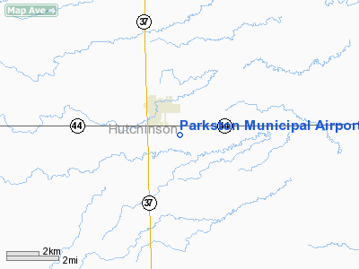
Location & QuickFacts
| FAA Information Effective: | 2008-09-25 |
| Airport Identifier: | 8V3 |
| Airport Status: | Operational |
| Longitude/Latitude: | 097-58-16.2580W/43-22-44.9530N
-97.971183/43.379154 (Estimated) |
| Elevation: | 1415 ft / 431.29 m (Surveyed) |
| Land: | 48 acres |
| From nearest city: | 1 nautical miles SW of Parkston, SD |
| Location: | Hutchinson County, SD |
| Magnetic Variation: | 07E (1985) |
Owner & Manager
| Ownership: | Publicly owned |
| Owner: | City Of Parkston |
| Address: | P O Box 236
Parkston, SD 57366 |
| Phone number: | 605-928-3321 |
| Manager: | Ray Doering |
| Address: | Po Box 490
Parkston, SD 57366 |
| Phone number: | 605-928-3696 |
Airport Operations and Facilities
| Airport Use: | Open to public |
| Wind indicator: | Yes |
| Segmented Circle: | Yes |
| Control Tower: | No |
| Lighting Schedule: | DUSK-DAWN
ACTVT MIRL RY 15/33 - 122.8. |
| Beacon Color: | Clear-Green (lighted land airport) |
| Landing fee charge: | No |
| Sectional chart: | Omaha |
| Region: | AGL - Great Lakes |
| Boundary ARTCC: | ZMP - Minneapolis |
| Tie-in FSS: | HON - Huron |
| FSS on Airport: | No |
| FSS Toll Free: | 1-800-WX-BRIEF |
| NOTAMs Facility: | HON (NOTAM-d service avaliable) |
| Federal Agreements: | NGY |
Airport Communications
Airport Services
Runway Information
Runway 15/33
| Dimension: | 3600 x 60 ft / 1097.3 x 18.3 m |
| Surface: | ASPH, Good Condition |
| Weight Limit: | Single wheel: 12000 lbs.
Dual wheel: 12500 lbs. |
| Edge Lights: | Medium |
| |
Runway 15 |
Runway 33 |
| Longitude: | 097-59-33.4600W | 097-59-15.4200W |
| Latitude: | 43-22-54.4500N | 43-22-27.9000N |
| Elevation: | 1414.00 ft | 1416.00 ft |
| Traffic Pattern: | Left | Left |
| Markings: | Non-precision instrument, Good Condition | Non-precision instrument, Good Condition |
| Crossing Height: | 43.00 ft | 35.00 ft |
| VASI: | 2-light PAPI on left side | 2-light PAPI on left side |
| Visual Glide Angle: | 3.00° | 3.00° |
| Runway End Identifier: | No | No |
| Centerline Lights: | No | No |
| Touchdown Lights: | No | No |
| Obstruction: | 49 ft pole, 1240.0 ft from runway, 200 ft left of centerline, 21:1 slope to clear | , 50:1 slope to clear |
|
Radio Navigation Aids
| ID |
Type |
Name |
Ch |
Freq |
Var |
Dist |
| AGZ | NDB | Wagner | | 392.00 | 08E | 23.7 nm |
| MHE | VOR/DME | Mitchell | 029X | 109.20 | 07E | 24.1 nm |
| YKN | VOR/DME | Yankton | 051X | 111.40 | 07E | 37.8 nm |
Images and information placed above are from
http://www.airport-data.com/airport/8V3/
We thank them for the data!
| General Info
|
| Country |
United States
|
| State |
SOUTH DAKOTA
|
| FAA ID |
8V3
|
| Latitude |
43-22-44.953N
|
| Longitude |
097-58-16.258W
|
| Elevation |
1415 feet
|
| Near City |
PARKSTON
|
We don't guarantee the information is fresh and accurate. The data may
be wrong or outdated.
For more up-to-date information please refer to other sources.
|
|


