 |
|
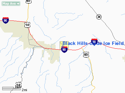
Black Hills-clyde Ice Field Airport |
Black Hills Airport
Clyde Ice Field |
| IATA: SPF – ICAO: KSPF – FAA LID: SPF |
| Summary |
| Airport type |
Public |
| Owner |
Lawrence County Airport Board |
| Location |
Spearfish, South Dakota |
| Elevation AMSL |
3,931 ft / 1,198 m |
| Coordinates |
44°28′49″N 103°46′59″W / 44.48028°N 103.78306°W / 44.48028; -103.78306 |
| Runways |
| Direction |
Length |
Surface |
| ft |
m |
| 13/31 |
5,498 |
1,676 |
Asphalt |
| 8/26 |
3,975 |
1,212 |
Turf |
| 17/35 |
3,900 |
1,189 |
Turf |
| 4/22 |
2,023 |
617 |
Turf |
| Statistics (2007) |
| Aircraft operations |
25,600 |
| Based aircraft |
78 |
| Source: Federal Aviation Administration |
Black Hills Airport (IATA: SPF, ICAO: KSPF, FAA LID: SPF), also known as Clyde Ice Field, is a county-owned public-use airport located three miles (5 km) east of the central business district of Spearfish, a city in Lawrence County, South Dakota, United States.
Facilities and aircraft
Black Hills-Clyde Ice Field covers an area of 485 acres (196 ha) which contains one paved runway designated 13/31 with 5,498 x 75 ft (1,676 x 23 m) asphalt surface. It also has three turf runways: 8/26 measuring 3,975 x 100 ft (1,212 x 30 m), 17/35 measuring 3,900 x 150 ft (1,189 x 46 m) and 4/22 measuring 2,023 x 150 ft (617 x 46 m).
For the 12-month period ending May 16, 2007, the airport had 25,600 aircraft operations, an average of 70 per day: 94% general aviation, 6% air taxi and <1% military. At that time there were 78 aircraft based at this airport: 87% single-engine, 9% multi-engine and 4% ultralight.
The above content comes from Wikipedia and is published under free licenses – click here to read more.
Location & QuickFacts
| FAA Information Effective: | 2008-09-25 |
| Airport Identifier: | SPF |
| Airport Status: | Operational |
| Longitude/Latitude: | 103-46-58.6500W/44-28-49.1600N
-103.782958/44.480322 (Estimated) |
| Elevation: | 3931 ft / 1198.17 m (Surveyed) |
| Land: | 485 acres |
| From nearest city: | 3 nautical miles E of Spearfish, SD |
| Location: | Lawrence County, SD |
| Magnetic Variation: | 11E (1990) |
Owner & Manager
| Ownership: | Publicly owned |
| Owner: | Lawrence County |
| Address: | 90 Sherman
Deadwood, SD 57732 |
| Phone number: | 605-578-1941 |
| Manager: | Ray Jilek |
| Address: | 300 Aviation Place
Spearfish, SD 57783 |
| Phone number: | 605-642-4112 |
Airport Operations and Facilities
| Airport Use: | Open to public |
| Wind indicator: | Yes |
| Segmented Circle: | Yes |
| Control Tower: | No |
| Lighting Schedule: | DUSK-DAWN
ACTVT MIRL RY 12/30 - CTAF. |
| Beacon Color: | Clear-Green (lighted land airport) |
| Landing fee charge: | No |
| Sectional chart: | Cheyenne |
| Region: | AGL - Great Lakes |
| Boundary ARTCC: | ZDV - Denver |
| Tie-in FSS: | HON - Huron |
| FSS on Airport: | No |
| FSS Toll Free: | 1-800-WX-BRIEF |
| NOTAMs Facility: | SPF (NOTAM-d service avaliable) |
| Federal Agreements: | NGY |
Airport Communications
| CTAF: | 122.700 |
| Unicom: | 122.700 |
Airport Services
| Fuel available: | 100LLA |
| Airframe Repair: | MAJOR |
| Power Plant Repair: | MAJOR |
| Bottled Oxygen: | HIGH |
| Bulk Oxygen: | HIGH |
Runway Information
Runway 03/21
| Dimension: | 2023 x 150 ft / 616.6 x 45.7 m |
| Surface: | TURF, Good Condition |
| |
Runway 03 |
Runway 21 |
| Longitude: | 103-46-50.0000W | 103-46-31.2170W |
| Latitude: | 44-28-37.9000N | 44-28-52.4410N |
| Elevation: | 3902.00 ft | 3862.00 ft |
| Alignment: | 43 | 127 |
| Traffic Pattern: | Left | Left |
| Runway End Identifier: | No | No |
| Centerline Lights: | No | No |
| Touchdown Lights: | No | No |
| Obstruction: | 18 ft hwy, 650.0 ft from runway, 36:1 slope to clear | 1 ft fence, 80.0 ft from runway, 50:1 slope to clear |
|
Runway 08/26
| Dimension: | 3975 x 100 ft / 1211.6 x 30.5 m |
| Surface: | TURF, Good Condition |
| |
Runway 08 |
Runway 26 |
| Longitude: | 103-47-38.2190W | 103-46-43.2000W |
| Latitude: | 44-28-35.9420N | 44-28-37.9000N |
| Elevation: | 3929.00 ft | 3900.00 ft |
| Alignment: | 87 | 127 |
| Traffic Pattern: | Left | Left |
| Runway End Identifier: | No | No |
| Centerline Lights: | No | No |
| Touchdown Lights: | No | No |
| Obstruction: | 18 ft tree, 200.0 ft from runway, 158 ft left of centerline, 11:1 slope to clear | , 50:1 slope to clear |
|
Runway 12/30
| Dimension: | 5498 x 75 ft / 1675.8 x 22.9 m |
| Surface: | ASPH, Good Condition |
| Weight Limit: | Single wheel: 30000 lbs.
Dual wheel: 40000 lbs. |
| Edge Lights: | Medium |
| |
Runway 12 |
Runway 30 |
| Longitude: | 103-47-31.0590W | 103-46-37.6200W |
| Latitude: | 44-29-13.7120N | 44-28-35.2100N |
| Elevation: | 3870.00 ft | 3898.00 ft |
| Alignment: | 127 | 127 |
| Traffic Pattern: | Right | Left |
| Markings: | Non-precision instrument, Fair Condition | Non-precision instrument, Fair Condition |
| Crossing Height: | 42.00 ft | 21.00 ft |
| Displaced threshold: | 0.00 ft | 424.00 ft |
| VASI: | 4-light PAPI on left side | 4-light PAPI on left side |
| Visual Glide Angle: | 3.30° | 3.00° |
| Runway End Identifier: | No | No |
| Centerline Lights: | No | No |
| Touchdown Lights: | No | No |
| Obstruction: | 98 ft hill, 2160.0 ft from runway, 380 ft left of centerline, 20:1 slope to clear | 28 ft road, 978.0 ft from runway, 5 ft right of centerline, 27:1 slope to clear
APCH 50:1 TO DSPLCD THLD. |
|
Runway 17/35
| Dimension: | 3900 x 150 ft / 1188.7 x 45.7 m |
| Surface: | TURF, Good Condition |
| |
Runway 17 |
Runway 35 |
| Longitude: | 103-46-47.7160W | 103-46-47.7180W |
| Latitude: | 44-29-15.4410N | 44-28-37.0000N |
| Elevation: | 3843.00 ft | 3906.00 ft |
| Alignment: | 127 | 127 |
| Traffic Pattern: | Left | Left |
| Runway End Identifier: | No | No |
| Centerline Lights: | No | No |
| Touchdown Lights: | No | No |
| Obstruction: | 10 ft road, 276.0 ft from runway, 27:1 slope to clear | 17 ft hwy, 729.0 ft from runway, 42:1 slope to clear |
|
Radio Navigation Aids
| ID |
Type |
Name |
Ch |
Freq |
Var |
Dist |
| SPF | NDB | Black Hills | | 300.00 | 11E | 0.3 nm |
| EFC | NDB | Belle Fourche | | 269.00 | 11E | 15.7 nm |
| RA | NDB | Ranch | | 254.00 | 11E | 45.8 nm |
| RCA | TACAN | Ellsworth | 025X | | 11E | 35.8 nm |
| ECS | VOR | Newcastle | | 108.20 | 11E | 42.5 nm |
| RAP | VORTAC | Rapid City | 070X | 112.30 | 13E | 44.9 nm |
Remarks
- IREG OPNS IN & OUT OF PVT AIRFIELD LOCATED APRXLY 3300 FT S OF ARPT; CHECK CTAF FREQ FOR STATUS.
- RY 21 +4 FT FENCE 50 FT R 141 FT FM RHLD & 50 FT L 175 FT FM THLD.,
- NO SNOW REMOVAL ON TURF RYS, CFM CONDS WITH AMGR, CALL 605-642-4112/2656.
- ULTRALIGHT ACTIVITY ON & INVOF ARPT.
- WILDLIFE ON AND INVOF ARPT.
Images and information placed above are from
http://www.airport-data.com/airport/SPF/
We thank them for the data!
| General Info
|
| Country |
United States
|
| State |
SOUTH DAKOTA
|
| FAA ID |
SPF
|
| Latitude |
44-28-49.160N
|
| Longitude |
103-46-58.650W
|
| Elevation |
3931 feet
|
| Near City |
SPEARFISH
|
We don't guarantee the information is fresh and accurate. The data may
be wrong or outdated.
For more up-to-date information please refer to other sources.
|
|


