 |
|
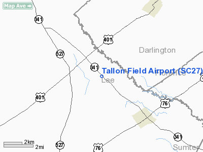
Location & QuickFacts
| FAA Information Effective: | 2008-09-25 |
| Airport Identifier: | SC27 |
| Airport Status: | Operational |
| Longitude/Latitude: | 080-07-32.2570W/34-06-03.5620N
-80.125627/34.100989 (Estimated) |
| Elevation: | 190 ft / 57.91 m (Estimated) |
| Land: | 6 acres |
| From nearest city: | 4 nautical miles N of Lynchburg, SC |
| Location: | Lee County, SC |
| Magnetic Variation: | 06W (1990) |
Owner & Manager
| Ownership: | Privately owned |
| Owner: | James B. Tallon Jr |
| Address: | 9 Mc Leod St
Lynchburg, SC 29089 |
| Phone number: | 803-437-2711 |
| Manager: | James B. Tallon Jr |
| Address: | 9 Mc Leod St
Lynchburg, SC 29089 |
| Phone number: | 803-437-2584 |
Airport Operations and Facilities
| Airport Use: | Private |
| Wind indicator: | Yes |
| Segmented Circle: | No |
| Control Tower: | No |
| Sectional chart: | Charlotte |
| Region: | ASO - Southern |
| Boundary ARTCC: | ZJX - Jacksonville |
| Tie-in FSS: | AND - Anderson |
| FSS Toll Free: | 1-800-WX-BRIEF |
Runway Information
Runway 05/23
| Dimension: | 3000 x 80 ft / 914.4 x 24.4 m |
| Surface: | TURF, |
| |
Runway 05 |
Runway 23 |
| Traffic Pattern: | Left | Left |
| Obstruction: | 75 ft trees, 100.0 ft from runway | 20 ft plines, 150.0 ft from runway |
|
Radio Navigation Aids
| ID |
Type |
Name |
Ch |
Freq |
Var |
Dist |
| SMS | NDB | Sumter | | 252.00 | 04W | 13.4 nm |
| HVS | NDB | Hartsville | | 341.00 | 07W | 18.4 nm |
| CFY | NDB | Evans | | 420.00 | 06W | 23.2 nm |
| UDG | NDB | Darlington | | 245.00 | 06W | 23.7 nm |
| CDN | NDB | Camden | | 263.00 | 05W | 24.3 nm |
| CKI | NDB | Kingstree | | 404.00 | 06W | 26.7 nm |
| MNI | NDB | Manning | | 381.00 | 06W | 31.1 nm |
| MMT | NDB | Mc Entire | | 427.00 | 05W | 35.0 nm |
| BES | NDB | Bennettsville | | 230.00 | 07W | 36.8 nm |
| HEK | NDB | Stuckey | | 236.00 | 06W | 37.4 nm |
| MAO | NDB | Marion | | 388.00 | 06W | 39.7 nm |
| PYG | NDB | Pageland | | 270.00 | 06W | 40.1 nm |
| CQW | NDB | Cheraw | | 409.00 | 05W | 40.6 nm |
| DLC | NDB | Dillon | | 274.00 | 05W | 43.1 nm |
| PHH | NDB | Andrews | | 255.00 | 06W | 49.2 nm |
| RCZ | NDB | Roscoe | | 375.00 | 07W | 50.0 nm |
| SSC | TACAN | Shaw | 038X | | 05W | 18.5 nm |
| CTF | VOR/DME | Chesterfield | 019X | 108.20 | 03W | 33.8 nm |
| FLO | VORTAC | Florence | 099X | 115.20 | 03W | 24.6 nm |
| MMT | VORTAC | Mc Entire | 079X | 113.20 | 05W | 35.4 nm |
| VAN | VORTAC | Vance | 041X | 110.40 | 06W | 41.0 nm |
| CAE | VORTAC | Columbia | 094X | 114.70 | 02W | 48.5 nm |
Remarks
- PRVD ALL OPNS ARE CONDUCTED IN VFR WX CONDS & LDG AREA IS LTD TO PVT USE.
Images and information placed above are from
http://www.airport-data.com/airport/SC27/
We thank them for the data!
| General Info
|
| Country |
United States
|
| State |
SOUTH CAROLINA
|
| FAA ID |
SC27
|
| Latitude |
34-06-03.562N
|
| Longitude |
080-07-32.257W
|
| Elevation |
190 feet
|
| Near City |
LYNCHBURG
|
We don't guarantee the information is fresh and accurate. The data may
be wrong or outdated.
For more up-to-date information please refer to other sources.
|
|


