 |
|
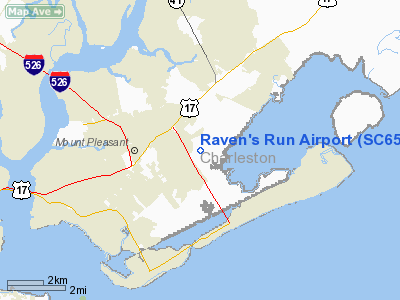
Location & QuickFacts
| FAA Information Effective: | 2008-09-25 |
| Airport Identifier: | SC65 |
| Airport Status: | Operational |
| Longitude/Latitude: | 079-48-24.2960W/32-49-25.6310N
-79.806749/32.823786 (Estimated) |
| Elevation: | 8 ft / 2.44 m (Estimated) |
| Land: | 6 acres |
| From nearest city: | 4 nautical miles NE of Mount Pleasant, SC |
| Location: | Charleston County, SC |
| Magnetic Variation: | 05W (1985) |
Owner & Manager
| Ownership: | Privately owned |
| Owner: | Raven's Run Hoa |
| Address: | 1414b Omni Blvd.
Mount Pleasant, SC 29464 |
| Phone number: | 803-747-7800 |
| Manager: | Cecil H. Mc Leod |
| Address: | 1535 Omni Blvd
Mount Pleasant, SC 29464 |
| Phone number: | 803-881-0702 |
Airport Operations and Facilities
| Airport Use: | Private |
| Wind indicator: | Yes |
| Segmented Circle: | No |
| Control Tower: | No |
| Landing fee charge: | No |
| Sectional chart: | Jacksonville |
| Region: | ASO - Southern |
| Boundary ARTCC: | ZJX - Jacksonville |
| Tie-in FSS: | AND - Anderson |
| FSS on Airport: | No |
| FSS Toll Free: | 1-800-WX-BRIEF |
Runway Information
Runway 15/33
| Dimension: | 2400 x 100 ft / 731.5 x 30.5 m |
| Surface: | TURF, |
| |
Runway 15 |
Runway 33 |
| Traffic Pattern: | Left | Left |
|
Radio Navigation Aids
| ID |
Type |
Name |
Ch |
Freq |
Var |
Dist |
| JZI | NDB | Johns Island | | 283.00 | 05W | 12.5 nm |
| CH | NDB | Ashly | | 329.00 | 05W | 17.3 nm |
| MKS | NDB | Moncks Corner | | 354.00 | 05W | 24.9 nm |
| DYB | NDB | Dorchester County | | 365.00 | 05W | 27.7 nm |
| GGE | NDB | Georgetown | | 242.00 | 06W | 38.3 nm |
| PHH | NDB | Andrews | | 255.00 | 06W | 40.3 nm |
| RBW | NDB | Walterboro | | 221.00 | 05W | 42.5 nm |
| CHS | VORTAC | Charleston | 082X | 113.50 | 05W | 12.4 nm |
| CHS | VOT | Charleston | | 111.00 | | 12.8 nm |
Remarks
Images and information placed above are from
http://www.airport-data.com/airport/SC65/
We thank them for the data!
| General Info
|
| Country |
United States
|
| State |
SOUTH CAROLINA
|
| FAA ID |
SC65
|
| Latitude |
32-49-25.631N
|
| Longitude |
079-48-24.296W
|
| Elevation |
8 feet
|
| Near City |
MOUNT PLEASANT
|
We don't guarantee the information is fresh and accurate. The data may
be wrong or outdated.
For more up-to-date information please refer to other sources.
|
|


