 |
|
| Pickens County Airport |
| IATA: LQK – ICAO: KLQK – FAA LID: LQK |
| Summary |
| Airport type |
Public |
| Owner |
Pickens County |
| Serves |
Pickens, South Carolina |
| Elevation AMSL |
1,013 ft / 309 m |
| Coordinates |
34°48′36″N 082°42′10″W / 34.81°N 82.70278°W / 34.81; -82.70278 |
| Runways |
| Direction |
Length |
Surface |
| ft |
m |
| 5/23 |
5,002 |
1,525 |
Asphalt |
| Statistics (2007) |
| Aircraft operations |
40,100 |
| Based aircraft |
34 |
| Source: Federal Aviation Administration |
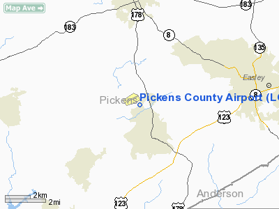
Pickens County Airport (IATA: LQK, ICAO: KLQK, FAA LID: LQK) is a county-owned public-use airport located four miles (6 km) south of the central business district of Pickens, in Pickens County, South Carolina, United States.
Facilities and aircraft
Pickens County Airport covers an area of 270 acres (109 ha) and contains one runway designated 5/23 with a 5,002 x 100 ft (1,525 x 30 m) asphalt pavement. For the 12-month period ending May 24, 2007, the airport had 40,100 aircraft operations, an average of 109 per day: 97% general aviation, 2% air taxi and <1% military. At that time there were 34 aircraft based at this airport: 79% single-engine, 12% multi-engine, 3% helicopter, 6% ultralight.
The above content comes from Wikipedia and is published under free licenses – click here to read more.
Location & QuickFacts
| FAA Information Effective: | 2008-09-25 |
| Airport Identifier: | LQK |
| Airport Status: | Operational |
| Longitude/Latitude: | 082-42-10.4000W/34-48-35.9000N
-82.702889/34.809972 (Estimated) |
| Elevation: | 1013 ft / 308.76 m (Surveyed) |
| Land: | 270 acres |
| From nearest city: | 4 nautical miles S of Pickens, SC |
| Location: | Pickens County, SC |
| Magnetic Variation: | 04W (1995) |
Owner & Manager
| Ownership: | Publicly owned |
| Owner: | Pickens County |
| Address: | 222 Mcdaniel Ave; B-2
Pickens, SC 29671 |
| Phone number: | 843-878-7800 |
| Manager: | Skeets Cooper |
| Address: | 240 Airport Road
29657 |
| Phone number: | 864-843-5803 |
Airport Operations and Facilities
| Airport Use: | Open to public |
| Wind indicator: | Yes |
| Segmented Circle: | Yes |
| Control Tower: | No |
| Lighting Schedule: | DUSK-DAWN
ACTVT MIRL RWY 5/23 - CTAF. |
| Beacon Color: | Clear-Green (lighted land airport) |
| Landing fee charge: | No |
| Sectional chart: | Atlanta |
| Region: | ASO - Southern |
| Boundary ARTCC: | ZTL - Atlanta |
| Tie-in FSS: | AND - Anderson |
| FSS on Airport: | No |
| FSS Toll Free: | 1-800-WX-BRIEF |
| NOTAMs Facility: | AND (NOTAM-d service avaliable) |
| Federal Agreements: | NGY |
Airport Communications
| CTAF: | 122.800 |
| Unicom: | 122.800 |
Airport Services
| Fuel available: | 100LLA |
| Airframe Repair: | MINOR |
| Bottled Oxygen: | NONE |
| Bulk Oxygen: | NONE |
Runway Information
Runway 05/23
| Dimension: | 5002 x 100 ft / 1524.6 x 30.5 m |
| Surface: | ASPH, Good Condition |
| Weight Limit: | Single wheel: 35000 lbs.
Dual wheel: 65000 lbs. |
| Edge Lights: | Medium |
| |
Runway 05 |
Runway 23 |
| Longitude: | 082-42-31.1570W | 082-41-49.5750W |
| Latitude: | 34-48-18.0780N | 34-48-53.7320N |
| Elevation: | 963.00 ft | 1013.00 ft |
| Alignment: | 44 | 127 |
| Traffic Pattern: | Left | Left |
| Markings: | Non-precision instrument, Good Condition | Non-precision instrument, Good Condition |
| Crossing Height: | 26.00 ft | 26.00 ft |
| VASI: | 2-light PAPI on left side | 2-light PAPI on left side |
| Visual Glide Angle: | 3.00° | 3.00° |
| Runway End Identifier: | No | No |
| Centerline Lights: | No | No |
| Touchdown Lights: | No | No |
| Obstruction: | 28 ft , 844.0 ft from runway, 127 ft right of centerline, 22:1 slope to clear | 44 ft , 1112.0 ft from runway, 241 ft right of centerline, 20:1 slope to clear |
|
Radio Navigation Aids
| ID |
Type |
Name |
Ch |
Freq |
Var |
Dist |
| CEU | NDB | Clemson | | 257.00 | 05W | 12.2 nm |
| GY | NDB | Dyana | | 338.00 | 03W | 14.7 nm |
| AND | NDB | Anderson County | | 230.00 | 04W | 18.7 nm |
| BRA | NDB | Broad River | | 379.00 | 04W | 30.1 nm |
| FRT | NDB | Fairmont | | 248.00 | 05W | 35.9 nm |
| LUX | NDB | Laurens | | 307.00 | 04W | 41.4 nm |
| GIW | NDB | Coronaca | | 239.00 | 04W | 45.3 nm |
| AJR | NDB | Habersham | | 347.00 | 03W | 45.8 nm |
| RFE | NDB | Rutherford | | 344.00 | 05W | 49.1 nm |
| ELW | VORTAC | Electric City | 023X | 108.60 | 00E | 23.8 nm |
| ODF | VORTAC | Foothills | 081X | 113.40 | 00E | 30.2 nm |
| SPA | VORTAC | Spartanburg | 104X | 115.70 | 02W | 40.5 nm |
| SUG | VORTAC | Sugarloaf Mountain | 059X | 112.20 | 02W | 41.7 nm |
| GRD | VORTAC | Greenwood | 102X | 115.50 | 01W | 43.2 nm |
Remarks
- NOISE ABATEMENT PROCEDURE IN EFFECT, PHONE 864-843-5803.
Images and information placed above are from
http://www.airport-data.com/airport/LQK/
We thank them for the data!
| General Info
|
| Country |
United States
|
| State |
SOUTH CAROLINA
|
| FAA ID |
LQK
|
| Latitude |
34-48-35.900N
|
| Longitude |
082-42-10.400W
|
| Elevation |
1013 feet
|
| Near City |
PICKENS
|
We don't guarantee the information is fresh and accurate. The data may
be wrong or outdated.
For more up-to-date information please refer to other sources.
|
|


