 |
|
Location & QuickFacts
| FAA Information Effective: | 2008-09-25 |
| Airport Identifier: | 12SC |
| Airport Status: | Operational |
| Longitude/Latitude: | 080-44-48.0000W/34-08-29.0000N
-80.746667/34.141389 (Estimated) |
| Elevation: | 250 ft / 76.20 m (Estimated) |
| Land: | 0 acres |
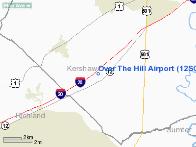
| From nearest city: | 5 nautical miles SE of Elgin, SC |
| Location: | Kershaw County, SC |
| Magnetic Variation: | 06W (2000) |
Owner & Manager
| Ownership: | Privately owned |
| Owner: | David Smith |
| Address: | 1380 Old White Pond Rd.
Elgin, SC 29045 |
| Phone number: | 803-438-3085 |
| Manager: | David Smith |
| Address: | 1380 Old White Pond Rd
Elgin, SC 29045 |
| Phone number: | 803-438-3085 |
Airport Operations and Facilities
| Airport Use: | Private |
| Segmented Circle: | No |
| Control Tower: | No |
| Sectional chart: | Charlotte |
| Region: | ASO - Southern |
| Boundary ARTCC: | ZJX - Jacksonville |
| Tie-in FSS: | AND - Anderson |
| FSS Toll Free: | 1-800-WX-BRIEF |
Runway Information
Runway 09/27
| Dimension: | 2400 x 100 ft / 731.5 x 30.5 m |
| Surface: | TURF, |
| |
Runway 09 |
Runway 27 |
| Traffic Pattern: | Left | Left |
|
Radio Navigation Aids
| ID |
Type |
Name |
Ch |
Freq |
Var |
Dist |
| CDN | NDB | Camden | | 263.00 | 05W | 12.6 nm |
| MMT | NDB | Mc Entire | | 427.00 | 05W | 12.6 nm |
| FDW | NDB | Winnsboro | | 414.00 | 05W | 21.0 nm |
| SMS | NDB | Sumter | | 252.00 | 04W | 21.3 nm |
| HVS | NDB | Hartsville | | 341.00 | 07W | 35.0 nm |
| LKR | NDB | Lancaster | | 400.00 | 07W | 35.4 nm |
| PYG | NDB | Pageland | | 270.00 | 06W | 41.5 nm |
| MNI | NDB | Manning | | 381.00 | 06W | 42.8 nm |
| OYI | NDB | Orangeburg | | 226.00 | 05W | 44.2 nm |
| DCM | NDB | Chester | | 220.00 | 06W | 44.9 nm |
| EOE | NDB | Enoree | | 278.00 | 05W | 45.4 nm |
| UDG | NDB | Darlington | | 245.00 | 06W | 46.4 nm |
| UZ | NDB | Rally | | 227.00 | 05W | 47.9 nm |
| TWL | NDB | Wesley | | 204.00 | 06W | 48.8 nm |
| SSC | TACAN | Shaw | 038X | | 05W | 17.1 nm |
| CTF | VOR/DME | Chesterfield | 019X | 108.20 | 03W | 38.5 nm |
| EDS | VOR/DME | Edisto | 051X | 111.40 | 05W | 41.6 nm |
| MMT | VORTAC | Mc Entire | 079X | 113.20 | 05W | 13.3 nm |
| CAE | VORTAC | Columbia | 094X | 114.70 | 02W | 22.9 nm |
| VAN | VORTAC | Vance | 041X | 110.40 | 06W | 42.7 nm |
Remarks
- OWNER DESIRES CHARTING.
- PROVIDED VFR OPNS, PRIVATE USE, AND TRAFFIC PATTERN TO THE SOUTH OF THE RY BE RESTRICTED TO CATEGORY A TYPE ACFT DUE TO PROXIMITY TO R-6001 A & B.
Images and information placed above are from
http://www.airport-data.com/airport/12SC/
We thank them for the data!
| General Info
|
| Country |
United States
|
| State |
SOUTH CAROLINA
|
| FAA ID |
12SC
|
| Latitude |
34-08-29.000N
|
| Longitude |
080-44-48.000W
|
| Elevation |
250 feet
|
| Near City |
ELGIN
|
We don't guarantee the information is fresh and accurate. The data may
be wrong or outdated.
For more up-to-date information please refer to other sources.
|
|


