 |
|
| Orangeburg Municipal Airport |
 |
| IATA: OGB – ICAO: KOGB |
| Summary |
| Airport type |
Public |
| Owner |
Public |
| Operator |
City of Orangeburg |
| Serves |
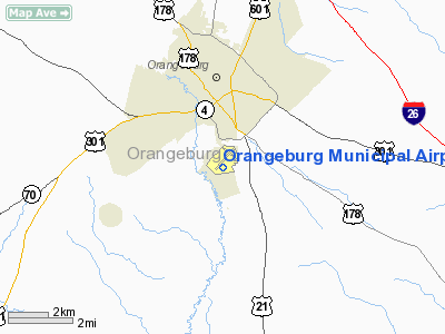
Orangeburg, South Carolina |
| Elevation AMSL |
195 ft / 59.4 m |
| Coordinates |
33°27′23.65″N 080°51′35.83″W / 33.4565694°N 80.8599528°W / 33.4565694; -80.8599528Coordinates: 33°27′23.65″N 080°51′35.83″W / 33.4565694°N 80.8599528°W / 33.4565694; -80.8599528 |
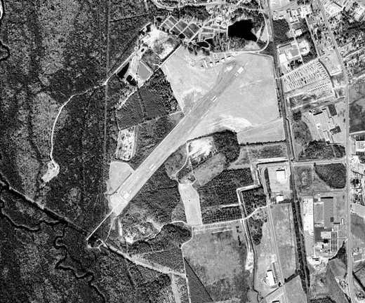
| Runways |
| Direction |
Length |
Surface |
| ft |
m |
| 17/35 |
5,399 |
1,646 |
Asphalt |
| 5/23 |
4,508 |
1,374 |
Asphalt |
Orangeburg Municipal Airport (IATA: OGB, ICAO: KOGB) is a public airport located 2 miles south of Orangeburg, South Carolina. The airport serves the general aviation community, with no scheduled commercial airline service. History
Orangeburg airport opened in November, 1937 as a public airport. In 1941 the United States Army Air Forces indicated a need for the airfield as a training airfield and control was turne over to the USAAF in February 1941. An immediate construction program began to turn the civil airport into a military airfield. Construction involved runways and airplane hangars, with three concrete runways, several taxiways and a large parking apron and a control tower. Several large hangars were also constructed. Buildings were ultimately utilitarian and quickly assembled. Most base buildings, not meant for long-term use, were constructed of temporary or semi-permanent materials. Although some hangars had steel frames and the occasional brick or tile brick building could be seen, most support buildings sat on concrete foundations but were of frame construction clad in little more than plywood and tarpaper.
Orangeburg Municipal Airport was activated on 23 August 1941 and was used by the Army Air Forces Flying Training Command, Southeast Training Center (later Eastern Flying Training Command) as a basic flying training airfield, with instruction being carried out by the 58th Flying Training Detachment (Contract Pilot School). The Hawthorne School of Aeronautics was the contractor who operated the primary flight school.
The primary trainer used at Orangeburg by the Hawthorne School of Aeronautics, the Boeing PT-17 Stearman. The president of Hawthorne was Beverly "Bevo" Howard, who had learned to fly at the age of 16. The military designation of the Hawthorne school was the 2162nd Army Air Force Base Unit.
The flight school at Orangeburg Airport operated several auxiliary airfields:
- Jennings Aux Field - Aux No. 1 Orangeburg 33°27′46″N 80°51′23″W / 33.46278°N 80.85639°W / 33.46278; -80.85639
- Hagood Aux Field - Aux No. 2 Orangeburg 33°26′00″N 80°40′30″W / 33.4333333°N 80.675°W / 33.4333333; -80.675
- Kennedy Aux Field - Aux No. 3 Orangeburg 33°23′40″N 81°02′00″W / 33.39444°N 81.0333333°W / 33.39444; -81.0333333
At the end of 1944, training of Free French pilots was transferred from Tuscaloosa, Alabama to Orangeburg. The unit was inactivated on 1 September 1945, and the airport returned to civil control
The above content comes from Wikipedia and is published under free licenses – click here to read more.
Location & QuickFacts
| FAA Information Effective: | 2008-09-25 |
| Airport Identifier: | OGB |
| Airport Status: | Operational |
| Longitude/Latitude: | 080-51-33.8640W/33-27-24.9041N
-80.859407/33.456918 (Estimated) |
| Elevation: | 195 ft / 59.44 m (Surveyed) |
| Land: | 300 acres |
| From nearest city: | 2 nautical miles S of Orangeburg, SC |
| Location: | Orangeburg County, SC |
| Magnetic Variation: | 05W (1985) |
Owner & Manager
| Ownership: | Publicly owned |
| Owner: | City Of Orangeburg |
| Address: | Po Box 387
Orangeburg, SC 29115 |
| Phone number: | 803-533-6010 |
| Manager: | Ron Kohler |
| Address: | 1811 Airport Road Se
Orangeburg, SC 29115 |
| Phone number: | 803-534-5545 |
Airport Operations and Facilities
| Airport Use: | Open to public |
| Wind indicator: | Yes |
| Segmented Circle: | Yes |
| Control Tower: | No |
| Lighting Schedule: | DUSK-DAWN
ACTVT MIRL RYS 05/23 & 17/35, ODALS RYS 17, 35 AND REIL RYS 05, 17 - CTAF. VASI RY 05 AND PAPI RYS 17 & 35 OPER CONT. |
| Beacon Color: | Clear-Green (lighted land airport) |
| Landing fee charge: | No |
| Sectional chart: | Charlotte |
| Region: | ASO - Southern |
| Boundary ARTCC: | ZJX - Jacksonville |
| Tie-in FSS: | AND - Anderson |
| FSS on Airport: | No |
| FSS Toll Free: | 1-800-WX-BRIEF |
| NOTAMs Facility: | OGB (NOTAM-d service avaliable) |
| Federal Agreements: | NGPY |
Airport Communications
| CTAF: | 122.700 |
| Unicom: | 122.700 |
Airport Services
| Fuel available: | 100LLA |
| Bottled Oxygen: | NONE |
| Bulk Oxygen: | NONE |
Runway Information
Runway 05/23
| Dimension: | 4508 x 100 ft / 1374.0 x 30.5 m |
| Surface: | ASPH, Good Condition |
| Weight Limit: | Single wheel: 30000 lbs.
Dual wheel: 50000 lbs. |
| Edge Lights: | Medium |
| |
Runway 05 |
Runway 23 |
| Longitude: | 080-51-49.9914W | 080-51-14.1737W |
| Latitude: | 33-27-22.9794N | 33-27-55.9553N |
| Elevation: | 170.00 ft | 195.00 ft |
| Alignment: | 42 | 127 |
| Traffic Pattern: | Right | Left |
| Markings: | Non-precision instrument, Good Condition | Non-precision instrument, Good Condition |
| Crossing Height: | 20.00 ft | 0.00 ft |
| VASI: | 4-box on left side | |
| Visual Glide Angle: | 3.00° | 0.00° |
| Runway End Identifier: | No | |
| Obstruction: | 93 ft tree, 2096.0 ft from runway, 373 ft left of centerline, 20:1 slope to clear | 53 ft tree, 1162.0 ft from runway, 302 ft right of centerline, 18:1 slope to clear |
|
Runway 17/35
| Dimension: | 5399 x 100 ft / 1645.6 x 30.5 m |
| Surface: | ASPH, Good Condition |
| Weight Limit: | Single wheel: 30000 lbs.
Dual wheel: 72000 lbs. |
| Edge Lights: | Medium |
| |
Runway 17 |
Runway 35 |
| Longitude: | 080-51-42.3619W | 080-51-28.3409W |
| Latitude: | 33-27-38.7986N | 33-26-46.6900N |
| Elevation: | 173.00 ft | 186.00 ft |
| Alignment: | 127 | 127 |
| Traffic Pattern: | Left | Left |
| Markings: | Non-precision instrument, Fair Condition | Non-precision instrument, Fair Condition |
| Crossing Height: | 42.00 ft | 42.00 ft |
| VASI: | 2-light PAPI on left side | 2-light PAPI on left side |
| Visual Glide Angle: | 3.00° | 3.00° |
| Approach lights: | ODALS | ODALS |
| Runway End Identifier: | Yes | |
| Obstruction: | 79 ft tree, 2239.0 ft from runway, 223 ft left of centerline, 25:1 slope to clear | 76 ft tree, 3145.0 ft from runway, 554 ft left of centerline, 38:1 slope to clear |
|
Radio Navigation Aids
| ID |
Type |
Name |
Ch |
Freq |
Var |
Dist |
| OYI | NDB | Orangeburg | | 226.00 | 05W | 3.3 nm |
| MMT | NDB | Mc Entire | | 427.00 | 05W | 28.9 nm |
| BKO | NDB | Barnwell | | 392.00 | 06W | 29.1 nm |
| MNI | NDB | Manning | | 381.00 | 06W | 33.7 nm |
| RBW | NDB | Walterboro | | 221.00 | 05W | 33.8 nm |
| DYB | NDB | Dorchester County | | 365.00 | 05W | 37.7 nm |
| SMS | NDB | Sumter | | 252.00 | 04W | 40.7 nm |
| AIK | NDB | Aiken | | 347.00 | 04W | 42.6 nm |
| MKS | NDB | Moncks Corner | | 354.00 | 05W | 44.5 nm |
| CH | NDB | Ashly | | 329.00 | 05W | 48.0 nm |
| SSC | TACAN | Shaw | 038X | | 05W | 37.0 nm |
| ALD | VOR | Allendale | | 116.70 | 01W | 34.5 nm |
| VAN | VORTAC | Vance | 041X | 110.40 | 06W | 20.6 nm |
| CAE | VORTAC | Columbia | 094X | 114.70 | 02W | 26.0 nm |
| MMT | VORTAC | Mc Entire | 079X | 113.20 | 05W | 28.2 nm |
Remarks
- +4 FT FENCE IN APCH AREA RY 13.
- RY 05 HAS MKD PLINES 1000 FT FRM THR.
- EXISTED PRIOR TO 1958.
Images and information placed above are from
http://www.airport-data.com/airport/OGB/
We thank them for the data!
| General Info
|
| Country |
United States
|
| State |
SOUTH CAROLINA
|
| FAA ID |
OGB
|
| Latitude |
33-27-39.400N
|
| Longitude |
080-51-32.100W
|
| Elevation |
195 feet
|
| Near City |
ORANGEBURG
|
We don't guarantee the information is fresh and accurate. The data may
be wrong or outdated.
For more up-to-date information please refer to other sources.
|
|


