 |
|
Oconee County Rgnl Airport |
| Oconee County Regional Airport |
 |
| IATA: CEU – ICAO: KCEU – FAA LID: CEU |
| Summary |
| Airport type |
Public |
| Owner |
Oconee County |
| Serves |
Clemson, South Carolina |
| Elevation AMSL |
892 ft / 272 m |
| Coordinates |
34°40′18.9″N 082°53′12.5″W / 34.671917°N 82.886806°W / 34.671917; -82.886806 |
| Runways |
| Direction |
Length |
Surface |
| ft |
m |
| 7/25 |
4,400 |
1,341 |
Asphalt |
| Statistics (2009) |
| Aircraft operations |
35,600 |
| Based aircraft |
49 |
| Source: Federal Aviation Administration |
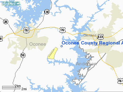
Oconee County Regional Airport (IATA: CEU, ICAO: KCEU, FAA LID: CEU) is a county-owned municipal airport in Oconee County, South Carolina, 3 miles (4.8 km) west of Clemson. Clemson University's Flying Club and the Flying Tigers Skydiving Club are based at the airport. During football season, the airport sees a spike in activity, due to its proximity to the University and Memorial Stadium.
Facilities and aircraft
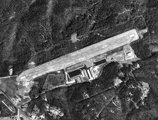
Oconee County Regional Airport covers an area of 262 acres (106 ha) at an elevation of 892 feet (272 m) above mean sea level. It has one asphalt paved runway deisgnated 7/25 which measures 4,400 by 100 feet (1,341 x 30 m).
For the 12-month period ending July 29, 2009, the airport had 35,600 aircraft operations, an average of 98 per day: 95% general aviation, 4% air taxi and less than 1% military. At that time there were 49 aircraft based at this airport: 48 single-engine and 1 multi-engine.
The above content comes from Wikipedia and is published under free licenses – click here to read more.
Location & QuickFacts
| FAA Information Effective: | 2008-09-25 |
| Airport Identifier: | CEU |
| Airport Status: | Operational |
| Longitude/Latitude: | 082-53-12.5000W/34-40-18.9000N
-82.886806/34.671917 (Estimated) |
| Elevation: | 892 ft / 271.88 m (Surveyed) |
| Land: | 262 acres |
| From nearest city: | 3 nautical miles W of Clemson, SC |
| Location: | Oconee County, SC |
| Magnetic Variation: | 05W (2000) |
Owner & Manager
| Ownership: | Publicly owned |
| Owner: | Oconee County |
| Address: | County Mail Room
Walhalla, SC 29691 |
| Phone number: | 864-638-4242 |
| Manager: | Kevin Short |
| Address: | 365 Airport Rd
Seneca, SC 29678 |
| Phone number: | 864-882-2959 |
Airport Operations and Facilities
| Airport Use: | Open to public |
| Wind indicator: | Yes |
| Segmented Circle: | Yes |
| Control Tower: | No |
| Lighting Schedule: | DUSK-DAWN
ACTVT MIRL RY 07/25 - CTAF. |
| Beacon Color: | Clear-Green (lighted land airport) |
| Landing fee charge: | No |
| Sectional chart: | Atlanta |
| Region: | ASO - Southern |
| Boundary ARTCC: | ZTL - Atlanta |
| Tie-in FSS: | AND - Anderson |
| FSS on Airport: | No |
| FSS Toll Free: | 1-800-WX-BRIEF |
| NOTAMs Facility: | CEU (NOTAM-d service avaliable) |
| Federal Agreements: | NGY |
Airport Communications
| CTAF: | 122.700 |
| Unicom: | 122.700 |
Airport Services
| Fuel available: | 100LLA |
| Airframe Repair: | MAJOR |
| Power Plant Repair: | MAJOR |
| Bottled Oxygen: | NONE |
| Bulk Oxygen: | NONE |
Runway Information
Runway 07/25
| Dimension: | 4400 x 100 ft / 1341.1 x 30.5 m |
| Surface: | ASPH, Good Condition |
| Weight Limit: | Single wheel: 26000 lbs. |
| Edge Lights: | Medium |
| |
Runway 07 |
Runway 25 |
| Longitude: | 082-53-36.9296W | 082-52-48.1593W |
| Latitude: | 34-40-10.6574N | 34-40-27.1286N |
| Elevation: | 888.00 ft | 879.00 ft |
| Alignment: | 68 | 127 |
| Traffic Pattern: | Right | Left |
| Markings: | Non-precision instrument, Good Condition | Non-precision instrument, Good Condition |
| Crossing Height: | 35.00 ft | 35.00 ft |
| VASI: | 2-light PAPI on left side | 2-light PAPI on left side |
| Visual Glide Angle: | 3.00° | 3.00° |
| Runway End Identifier: | Yes | Yes |
| Obstruction: | 44 ft tree, 1158.0 ft from runway, 225 ft left of centerline, 21:1 slope to clear | 13 ft tree, 331.0 ft from runway, 186 ft right of centerline, 10:1 slope to clear
10-15 FT BUSHES IN PRIMARY SURFACE BOTH SIDES OF RUNWAY. |
|
Radio Navigation Aids
| ID |
Type |
Name |
Ch |
Freq |
Var |
Dist |
| CEU | NDB | Clemson | | 257.00 | 05W | 0.1 nm |
| LQK | NDB | Lake Keowee | | 408.00 | 04W | 12.3 nm |
| AND | NDB | Anderson County | | 230.00 | 04W | 13.7 nm |
| GY | NDB | Dyana | | 338.00 | 03W | 21.9 nm |
| AJR | NDB | Habersham | | 347.00 | 03W | 34.4 nm |
| BRA | NDB | Broad River | | 379.00 | 04W | 41.5 nm |
| BJT | NDB | Bulldog | | 221.00 | 03W | 46.3 nm |
| FRT | NDB | Fairmont | | 248.00 | 05W | 46.6 nm |
| GIW | NDB | Coronaca | | 239.00 | 04W | 47.0 nm |
| LUX | NDB | Laurens | | 307.00 | 04W | 47.4 nm |
| DDA | NDB | Commerce | | 244.00 | 03W | 48.3 nm |
| ELW | VORTAC | Electric City | 023X | 108.60 | 00E | 16.0 nm |
| ODF | VORTAC | Foothills | 081X | 113.40 | 00E | 20.4 nm |
| GRD | VORTAC | Greenwood | 102X | 115.50 | 01W | 44.2 nm |
| AHN | VORTAC | Athens | 33 | 109.60 | 00E | 48.7 nm |
Remarks
- NO LINE-OF-SIGHT BETWEEN RWY ENDS.
- ACFT MAY BE OPERATING FROM PVT ARPT 1 NM WEST-NORTHWEST OF ARPT.
Images and information placed above are from
http://www.airport-data.com/airport/CEU/
We thank them for the data!
| General Info
|
| Country |
United States
|
| State |
SOUTH CAROLINA
|
| FAA ID |
CEU
|
| Latitude |
34-40-18.901N
|
| Longitude |
082-53-12.541W
|
| Elevation |
892 feet
|
| Near City |
CLEMSON
|
We don't guarantee the information is fresh and accurate. The data may
be wrong or outdated.
For more up-to-date information please refer to other sources.
|
|


