 |
|
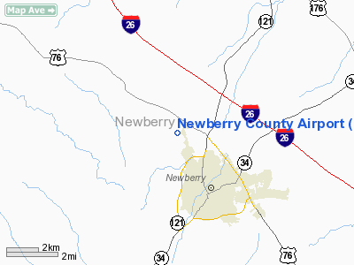
Location & QuickFacts
| FAA Information Effective: | 2008-09-25 |
| Airport Identifier: | EOE |
| Airport Status: | Operational |
| Longitude/Latitude: | 081-38-23.0000W/34-18-33.4000N
-81.639722/34.309278 (Estimated) |
| Elevation: | 568 ft / 173.13 m (Surveyed) |
| Land: | 196 acres |
| From nearest city: | 3 nautical miles N of Newberry, SC |
| Location: | Newberry County, SC |
| Magnetic Variation: | 05W (1990) |
Owner & Manager
| Ownership: | Publicly owned |
| Owner: | Newberry County |
| Address: | Po Box 156
Newberry, SC 29108 |
| Phone number: | 803-321-2100 |
| Manager: | Tommy Whitehead
NEWBERRY COUNTY PUBLIC WORKS DIRECTOR. |
| Address: | 11374 Sc. Hwy. 34
Newberry, SC 29108 |
| Phone number: | 803-321-2180
(803) 321-2383 FAX. |
Airport Operations and Facilities
| Airport Use: | Open to public |
| Wind indicator: | Yes |
| Segmented Circle: | Yes |
| Control Tower: | No |
| Lighting Schedule: | DUSK-DAWN |
| Beacon Color: | Clear-Green (lighted land airport) |
| Landing fee charge: | No |
| Sectional chart: | Atlanta |
| Region: | ASO - Southern |
| Boundary ARTCC: | ZTL - Atlanta |
| Responsible ARTCC: | ZJX - Jacksonville |
| Tie-in FSS: | AND - Anderson |
| FSS on Airport: | No |
| FSS Toll Free: | 1-800-WX-BRIEF |
| NOTAMs Facility: | AND (NOTAM-d service avaliable) |
| Federal Agreements: | NY1 |
Airport Communications
| CTAF: | 122.800 |
| Unicom: | 122.800 |
Airport Services
| Fuel available: | 100LL
SELF-SERVE. |
| Airframe Repair: | MAJOR |
| Power Plant Repair: | MAJOR |
| Bottled Oxygen: | NONE |
| Bulk Oxygen: | NONE |
Runway Information
Runway 04/22
| Dimension: | 3498 x 60 ft / 1066.2 x 18.3 m |
| Surface: | ASPH, Fair Condition |
| Surface Treatment: | Aggregate Friction Seal Coat |
| Weight Limit: | Single wheel: 12500 lbs. |
| Edge Lights: | Low |
| |
Runway 04 |
Runway 22 |
| Longitude: | 081-38-35.4820W | 081-38-10.4260W |
| Latitude: | 34-18-19.5420N | 34-18-47.1950N |
| Elevation: | 541.00 ft | 568.00 ft |
| Alignment: | 37 | 127 |
| Traffic Pattern: | Left | Right |
| Markings: | Non-precision instrument, Fair Condition | Non-precision instrument, Fair Condition |
| Crossing Height: | 0.00 ft | 25.00 ft |
| VASI: | | 2-box SAVASI on left side
SAVASI OTS INDEFLY. |
| Visual Glide Angle: | 0.00° | 3.60° |
| Obstruction: | 82 ft tree, 1258.0 ft from runway, 320 ft left of centerline, 12:1 slope to clear | 46 ft tree, 256.0 ft from runway, 100 ft right of centerline, 1:1 slope to clear
+15 FT DIRT ROAD 140 FT FROM THLD. |
|
Radio Navigation Aids
| ID |
Type |
Name |
Ch |
Freq |
Var |
Dist |
| EOE | NDB | Enoree | | 278.00 | 05W | 0.2 nm |
| LUX | NDB | Laurens | | 307.00 | 04W | 19.5 nm |
| GIW | NDB | Coronaca | | 239.00 | 04W | 22.4 nm |
| UOT | NDB | Union County | | 326.00 | 04W | 22.5 nm |
| FDW | NDB | Winnsboro | | 414.00 | 05W | 26.2 nm |
| DCM | NDB | Chester | | 220.00 | 06W | 36.0 nm |
| FRT | NDB | Fairmont | | 248.00 | 05W | 39.5 nm |
| AIK | NDB | Aiken | | 347.00 | 04W | 39.6 nm |
| UZ | NDB | Rally | | 227.00 | 05W | 44.5 nm |
| GY | NDB | Dyana | | 338.00 | 03W | 46.0 nm |
| LKR | NDB | Lancaster | | 400.00 | 07W | 46.0 nm |
| MMT | NDB | Mc Entire | | 427.00 | 05W | 47.5 nm |
| GRD | VORTAC | Greenwood | 102X | 115.50 | 01W | 25.8 nm |
| CAE | VORTAC | Columbia | 094X | 114.70 | 02W | 39.9 nm |
| IRQ | VORTAC | Colliers | 086X | 113.90 | 04W | 44.6 nm |
| SPA | VORTAC | Spartanburg | 104X | 115.70 | 02W | 45.8 nm |
| MMT | VORTAC | Mc Entire | 079X | 113.20 | 05W | 47.7 nm |
Remarks
- DEER ON & INVOF ARPT.
- EXISTED PRIOR TO 1958.
Images and information placed above are from
http://www.airport-data.com/airport/EOE/
We thank them for the data!
|
|


