 |
|
Location & QuickFacts
| FAA Information Effective: | 2008-09-25 |
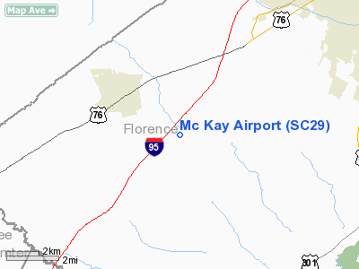
| Airport Identifier: | SC29 |
| Airport Status: | Operational |
| Longitude/Latitude: | 079-54-05.2380W/34-06-38.5640N
-79.901455/34.110712 (Estimated) |
| Elevation: | 135 ft / 41.15 m (Estimated) |
| Land: | 0 acres |
| From nearest city: | 3 nautical miles SE of Timmonsville, SC |
| Location: | Florence County, SC |
| Magnetic Variation: | 06W (1985) |
Owner & Manager
| Ownership: | Privately owned |
| Owner: | Woody Mc Kay |
| Address: | Rt 1 Mc Kay Rd Po Box 500
Timmonsville, SC 29161 |
| Phone number: | 803-346-2436 |
| Manager: | Woody Mc Kay |
| Address: | Rt 1
Timmonsville, SC 29161 |
| Phone number: | 803-346-2436 |
Airport Operations and Facilities
| Airport Use: | Private |
| Wind indicator: | Yes |
| Segmented Circle: | No |
| Control Tower: | No |
| Landing fee charge: | No |
| Sectional chart: | Charlotte |
| Region: | ASO - Southern |
| Boundary ARTCC: | ZJX - Jacksonville |
| Tie-in FSS: | AND - Anderson |
| FSS on Airport: | No |
| FSS Toll Free: | 1-800-WX-BRIEF |
Airport Services
| Airframe Repair: | NONE |
| Power Plant Repair: | NONE |
Runway Information
Runway 15/33
| Dimension: | 3000 x 70 ft / 914.4 x 21.3 m |
| Surface: | TURF, |
| |
Runway 15 |
Runway 33 |
| Traffic Pattern: | Right | Left |
|
Radio Navigation Aids
| ID |
Type |
Name |
Ch |
Freq |
Var |
Dist |
| CFY | NDB | Evans | | 420.00 | 06W | 16.7 nm |
| UDG | NDB | Darlington | | 245.00 | 06W | 20.0 nm |
| HVS | NDB | Hartsville | | 341.00 | 07W | 20.8 nm |
| CKI | NDB | Kingstree | | 404.00 | 06W | 23.7 nm |
| SMS | NDB | Sumter | | 252.00 | 04W | 23.9 nm |
| MAO | NDB | Marion | | 388.00 | 06W | 28.6 nm |
| HEK | NDB | Stuckey | | 236.00 | 06W | 29.7 nm |
| BES | NDB | Bennettsville | | 230.00 | 07W | 31.7 nm |
| DLC | NDB | Dillon | | 274.00 | 05W | 33.4 nm |
| CDN | NDB | Camden | | 263.00 | 05W | 34.4 nm |
| MNI | NDB | Manning | | 381.00 | 06W | 34.9 nm |
| CQW | NDB | Cheraw | | 409.00 | 05W | 38.0 nm |
| HYW | NDB | Horry | | 370.00 | 08W | 42.2 nm |
| ME | NDB | Maxtn | | 257.00 | 08W | 43.8 nm |
| PHH | NDB | Andrews | | 255.00 | 06W | 43.8 nm |
| PYG | NDB | Pageland | | 270.00 | 06W | 43.8 nm |
| RCZ | NDB | Roscoe | | 375.00 | 07W | 45.8 nm |
| MMT | NDB | Mc Entire | | 427.00 | 05W | 45.9 nm |
| JB | NDB | Jigel | | 384.00 | 08W | 46.0 nm |
| SSC | TACAN | Shaw | 038X | | 05W | 29.2 nm |
| CTF | VOR/DME | Chesterfield | 019X | 108.20 | 03W | 37.4 nm |
| FLO | VORTAC | Florence | 099X | 115.20 | 03W | 14.2 nm |
| MMT | VORTAC | Mc Entire | 079X | 113.20 | 05W | 46.3 nm |
| VAN | VORTAC | Vance | 041X | 110.40 | 06W | 47.0 nm |
Remarks
- VFR, PVT USE ONLY; COMPATIBLE OPNL AGREEMENT IS REACHED WITH OPERATOR OF HUGGINS ARPT.
Images and information placed above are from
http://www.airport-data.com/airport/SC29/
We thank them for the data!
| General Info
|
| Country |
United States
|
| State |
SOUTH CAROLINA
|
| FAA ID |
SC29
|
| Latitude |
34-06-38.564N
|
| Longitude |
079-54-05.238W
|
| Elevation |
135 feet
|
| Near City |
TIMMONSVILLE
|
We don't guarantee the information is fresh and accurate. The data may
be wrong or outdated.
For more up-to-date information please refer to other sources.
|
|


