|
 |
|
||||
|
Coordinates: 33°55′15″N 080°48′04″W / 33.92083°N 80.80111°W
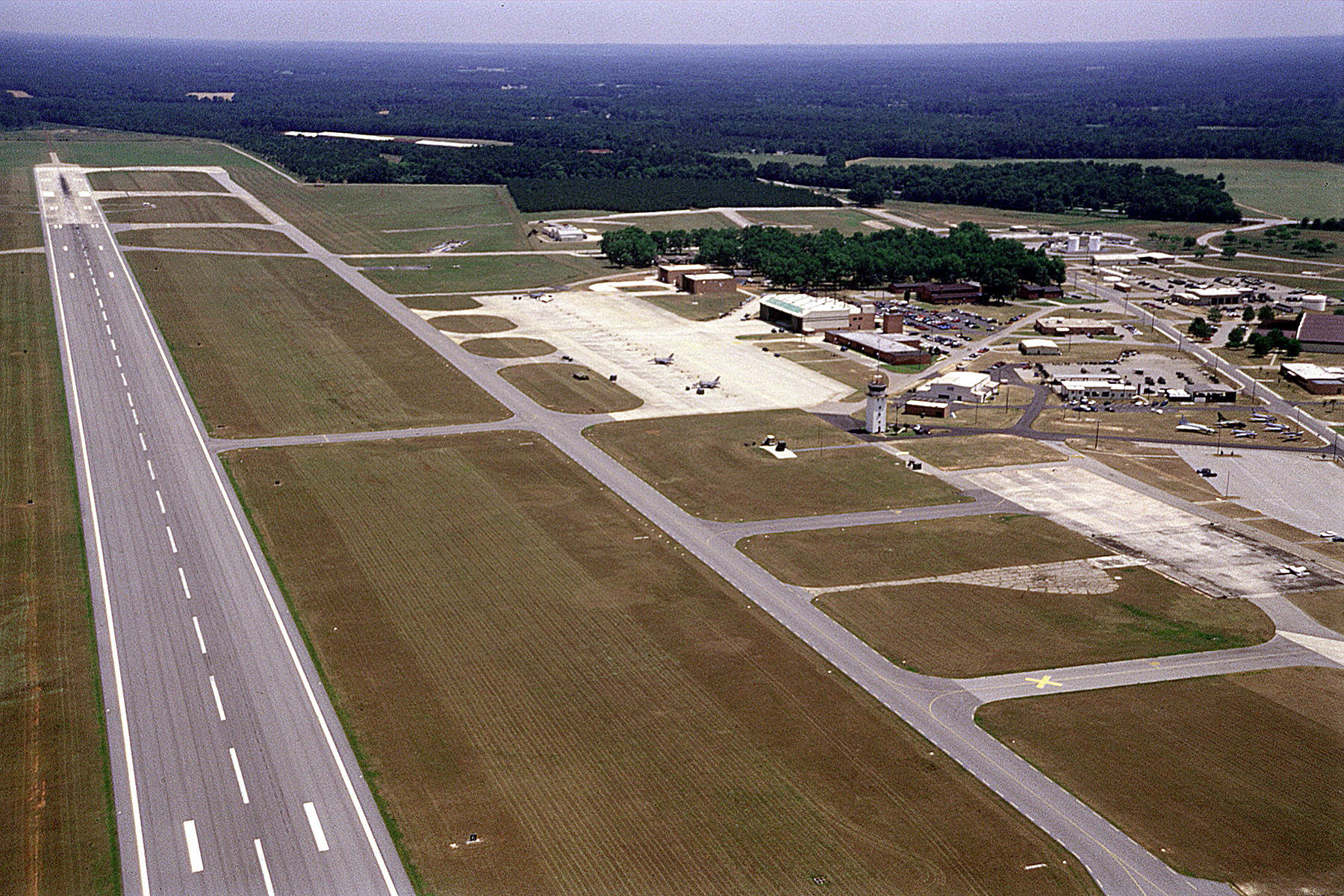
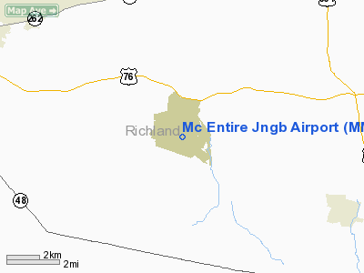
McEntire Joint National Guard Base or McEntire JNGB (IATA: MMT, ICAO: KMMT, FAA LID: MMT) is a military airport located in Richland County, South Carolina, United States, 10 miles (16 km) east of the town of Eastover and approximately 15 miles southeast of the city of Columbia. It is owned by U.S. Air Force affiliated with the South Carolina Air National Guard (SCANG). The base is named for the late Brigadier General Barnie B. McEntire, Jr., the first commander of the SCANG and its first general officer. McEntire died on 25 May 1961 when he rode his malfunctioning F-104 Starfighter into the Susquehanna River to avoid crashing in the populated area of Harrisburg, Pennsylvania. The South Carolina Air National Guard was formed in December 1946. Today 1,250 members train at McEntire JNGS. About 900 of those are traditional Guard men and women. About 300 are full-time federal employees (technicians). About 50 are state employees (some of them are also traditional Guard members). The 169th Fighter Wing is the primary unit of the SCANG. Resident unit169th Fighter Wing169th Fighter Wing contains:
HistoryThe United States Army began construction on an airfield on land north of Congaree to be an outlying base to the Columbia Army Airbase. The original designation of the airfield was Congaree Army Airport, then Fort Jackson Airdrome, and finally Congree Army Airfield. Construction was completed on January 31, 1943 with the completion of three 4,500 ft runways. Congaree AAF was assigned to Third Air Force III Air Support Command. From January 1943 until May of 1944 the airfield hosted various Army dive bombing training units. The 404th Bombardment Group (Dive) arrived at Congaree on 5 July 1943, departing 4 September. The 406th Bombardment Group (Dive) replaced it, arriving on 18 Sep 1943 and remaining until being deployed to Ninth Air Force in England on 18 March 1944. On 31 March 1944, Congree was removed from the jurisdiction of Columbia AAB, and on 30 April Congaree AAF was transferred to the United States Navy The first Marines arrived in May 1944 to a deserted base. During May Marine Aircraft Group 52 (MAG-52) arrived with four F4U Corsair squadrons. The field was officially commissioned as Marine Corps Auxiliary Airfield Congaree on July 10, 1944. The base fell under the command of Marine Corps Air Station Cherry Point. In October of that year MAG-52's mission was changed to that of training replacement pilots, was redesignated Marine Aircraft Group 92 and moved to Marine Corps Air Field Walnut Ridge. One of the fields major problems was a lack of bombing and gunnery ranges, which meant regular deployments to Marine Corps Air Station Parris Island for training. In September 1945, after World War II, the only remaining Marine units were VMF-523 and Air Warning Squadron 14. By November all Marine units had moved back to MCAS Cherry Point. The base was eventually turned over to the South Carolina Air National Guard and re-named McEntire ANG Base in October 1961 by Governor Ernest F. Hollings. It was re-named McEntire Joint National Guard Station in 2005 to reflect the joint presence of Army and Air National Guard units. South Carolina Air National Guard
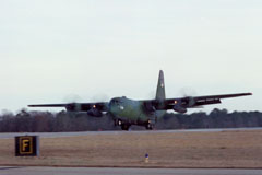
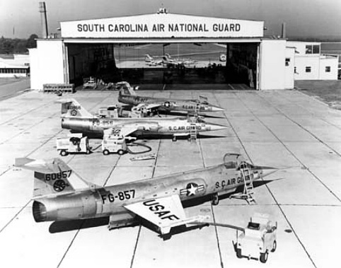
The mission of the 169th Fighter Wing (169 FW) is to maintain wartime readiness and the ability to mobilize and deploy expeditiously to carry out tactical air missions or combat support activities in the event of a war or military emergency. The SCANG operates as part of the Total Force of the U.S. military and is fully integrated with the active duty Air Force as a gained unit of the Air Combat Command (ACC) to perform its military mission. The South Carolina Air National Guard also has a state mission, to respond to the call of the governor in the event of natural disaster or domestic disturbance. The 169 FW flies the F-16 Fighting Falcon, a single-seat multi-purpose fighter with the capability to fly at up to twice the speed of sound. The 169 FW was the first wing in the Air National Guard to fly the F-16. The 169 FW flew the F-16A from 1983-1994. In 1994, the wing transitioned to the F-16C/Block 52, the newest, most advanced F-16 in the Air Force inventory. The SCANG also flies two C-130H Hercules for airlift support. Prior to operating the F-16, the 169 FW operated the A-7 Corsair II during the 1970s and early 1980s and the F-102 Delta Dart and F-104 Starfighter in the 1960s. In the 1950s a succession of F-51 Mustangs, F-80 Shooting Stars and F-86 Saber Jets operated from the then Congaree ANGB. Also located at McEntire is the 240th Combat Communications Squadron (240 CCS), a diversified communications unit with more than 100 members; and the 245th Air Traffic Control Squadron (245 ATCS). The many missions of the 240 CCS include ground communications, satellite communications and other advanced communications systems. The 245 ATCS has the ability to perform air traffic control at fixed air bases and at remote sites. History of the South Carolina Air National GuardThe SCANG has been called to active military service for five major contingency deployments in its 55-year history. In 1950, SCANG members were called to serve for the Korean War, and its members served at various installations in the United States and abroad. In late 1961, the SCANG was called to active duty during the Berlin Crisis, and the 169th Tactical Fighter Group was stationed at Moron, Spain. In late 1990, units of the SCANG were activated and deployed to Saudi Arabia for Operation Desert Shield/Storm, flying 2,000 combat missions and dropping 4 million pounds of munitions, while maintaining the highest aircraft mission capable rate in the theater. In January 2002, aircraft and personnel of the 169th Fighter Wing were deployed to Southwest Asia in support of Operation Enduring Freedom, directly participating in combat operations. In late February 2002, the 240th CCBS deployed a 50-member team to Central Asia in support of War on Terrorism. The 240th members returned in August after six months in theater. In September 2002, the 245th ATCS deployed to Afghanistan Asia in support of Operation Enduring Freedom, returning in January 2003. In February 2003, nearly 400 members of the 169th FW and all of its F-16s were mobilized and deployed to Southwest Asia as part of what became Operation Iraqi Freedom. The 169th was attached to the 379th Air Expeditionary Wing, stationed in Qatar. The unit flew more than 400 combat missions, performing the Suppression of Enemy Air Defenses (SEAD) mission and flying numerous precision bombing missions over Iraq. The 169th FW was also a regular participant in the Air Expeditionary Force, which patrolled the Iraqi no-fly zones. The unit has deployed for: Operation Southern Watch (Qatar, 1996), Operation Northern Watch (Turkey, 2000), Operation Southern Watch (Saudi Arabia, 2001). The 169th FW was the first Air National Guard unit to deploy alongside active-duty Air Force units to comprise an AEF. The above content comes from Wikipedia and is published under free licenses – click here to read more.
Location & QuickFacts
Owner & Manager
Airport Operations and Facilities
Airport Communications
Airport Services
Runway InformationRunway 05/23
Runway 14/32
Runway 18/36
Radio Navigation Aids
Remarks
Images and information placed above are from We thank them for the data!
We don't guarantee the information is fresh and accurate. The data may
be wrong or outdated.
|
|||||||||||||||||||||||||||||||||||||||||||||||||||||||||||||||||||||||||||||||||||||||||||||||||||||||||||||||||||||||||||||||||||||||||||||||||||||||||||||||||||||||||||||||||||||||||||||||||||||||||||||||||||||||||||||||||||||||||||||||||||||||||||||||||||||||||||||||||||||||||||||||||||||||||||||||||||||||||||||||||||||||||||||||||||||||||||||||||||||||||||||||||||||||||||||||||||||||||||||||||||||||

 |
|
Copyright 2004-2026 © by Airports-Worldwide.com, Vyshenskoho st. 36, Lviv 79010, Ukraine Legal Disclaimer |