|
|
| Lowcountry Regional Airport |
 |
| IATA: RBW – ICAO: KRBW |
| Summary |
| Airport type |
Public |
| Owner |
Public |
| Operator |
City of Walterboro and County |
| Serves |
Walterboro, South Carolina |
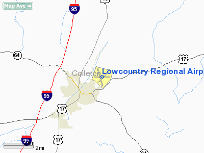
| Location |
Colleton County, near Walterboro, South Carolina |
| Elevation AMSL |
101 ft / 30.8 m |
| Coordinates |
32°55′15.60″N 080°38′26.20″W / 32.921°N 80.640611°W / 32.921; -80.640611Coordinates: 32°55′15.60″N 080°38′26.20″W / 32.921°N 80.640611°W / 32.921; -80.640611 |
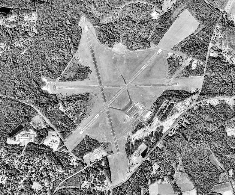
| Runways |
| Direction |
Length |
Surface |
| ft |
m |
| 5/23 |
6,002 |
1,829 |
Asphalt |
| 17/35 |
5,705 |
1,730 |
Asphalt |
| 9/27 |
5,408 |
1,648 |
Asphalt |
Lowcountry Regional Airport (IATA: RBW, ICAO: KRBW) is a public airport located 2 miles northeast of Walterboro, South Carolina. The airport serves the general aviation community, with no scheduled commercial airline service. History
The airport was opened in October 1937. In 1942 the United States Army Air Forces indicated a need for the airfield as a training airfield and control was turned over to the USAAF in February 1942. An immediate construction program began to turn the civil airport into a military airfield. Construction involved runways and airplane hangars, with three concrete runways, several taxiways and a large parking apron and a control tower. Several large hangars were also constructed. Buildings were ultimately utilitarian and quickly assembled. Most base buildings, not meant for long-term use, were constructed of temporary or semi-permanent materials. Although some hangars had steel frames and the occasional brick or tile brick building could be seen, most support buildings sat on concrete foundations but were of frame construction clad in little more than plywood and tarpaper. Walterboro Army Airfield was assigned to Third Air Force III Air Support Command, and activated on 15 August 1942. The 305th Air Base Group was the station host unit.
Initially Walterboro AAF was used primarily for training of B-25 Mitchell medium bomber pilots and aircrews, acting a sub-base of Columbia Army Airfield for follow-on training prior to the units being deployed to overseas combat theaters. Units assigned to the airfield during World War II were:
- 310th Bombardment Group (Medium), 11 August-18 September 1942
- 321st Bombardment Group (Medium), September 1942-18 December 1942
- 340th Bombardment Group (Medium), 30 November 1942-30 January 1943
- 345th Bombardment Group (Medium), 6 March-16 April 1943
- 405th Fighter-Bomber Group, 14 September 1943-14 September 1944, (A-24 Dauntless A-25 Shrike)
Walterboro AAF also hosted the largest camouflage school in the United States, as well as a 250 person Prisoner of War Camp. In 1944 it was reassigned to First Air Force and became an advanced combat training base for individual fighters, primarily the black trainees graduating from Tuskegee Army Air Field in Tuskegee, Alabama. Over 500 of the famed Tuskegee Airmen trained at Walterboro Army Air Field between April 1944 and October 1945 including individuals training as replacement pilots for the 332nd Fighter Squadron and the entire 447th Bombardment Group.
The base closed on 31 October 1945 and returned to its origins as a local airfield.
The above content comes from Wikipedia and is published under free licenses – click here to read more.
Location & QuickFacts
| FAA Information Effective: | 2008-09-25 |
| Airport Identifier: | RBW |
| Airport Status: | Operational |
| Longitude/Latitude: | 080-38-26.2000W/32-55-15.6000N
-80.640611/32.921000 (Estimated) |
| Elevation: | 101 ft / 30.78 m (Surveyed) |
| Land: | 1400 acres |
| From nearest city: | 2 nautical miles NE of Walterboro, SC |
| Location: | Colleton County, SC |
| Magnetic Variation: | 05W (1990) |
Owner & Manager
| Ownership: | Publicly owned |
| Owner: | City Of Walterboro And County |
| Address: | Box 709
Walterboro, SC 29488 |
| Phone number: | 843-549-2545 |
| Manager: | Tommy Rowe |
| Address: | P.o. Box 1234
Walterboro, SC 29488 |
| Phone number: | 843-549-7575 |
Airport Operations and Facilities
| Airport Use: | Open to public |
| Wind indicator: | Yes
TETRAHEDRON WIND INDICATOR. |
| Segmented Circle: | No |
| Control Tower: | No |
| Lighting Schedule: | DUSK-DAWN
PAPI RYS 05 & 23 AND ODALS RY 23 OPER CONT. PHOTOCELL AT DUSK, GO OFF AT 10:00PM AND OPERATE BY RADIO CONTROL UNTIL DAWN. |
| Beacon Color: | Clear-Green (lighted land airport) |
| Landing fee charge: | No |
| Sectional chart: | Charlotte |
| Region: | ASO - Southern |
| Boundary ARTCC: | ZJX - Jacksonville |
| Tie-in FSS: | AND - Anderson |
| FSS on Airport: | No |
| FSS Toll Free: | 1-800-WX-BRIEF |
| NOTAMs Facility: | AND (NOTAM-d service avaliable) |
| Federal Agreements: | NGRY3 |
Airport Communications
| CTAF: | 122.800 |
| Unicom: | 122.800 |
Airport Services
| Fuel available: | 100LLA
100LL SELF-SVC FUEL AVBL 24 HRS. |
| Airframe Repair: | MAJOR |
| Power Plant Repair: | MAJOR |
| Bottled Oxygen: | NONE |
| Bulk Oxygen: | NONE |
Runway Information
Runway 05/23
| Dimension: | 6002 x 100 ft / 1829.4 x 30.5 m |
| Surface: | ASPH-CONC, Good Condition |
| Weight Limit: | Single wheel: 26000 lbs.
Dual wheel: 35000 lbs. |
| Edge Lights: | Medium |
| |
Runway 05 |
Runway 23 |
| Longitude: | 080-38-43.2448W | 080-37-54.2790W |
| Latitude: | 32-54-56.6003N | 32-55-39.2751N |
| Elevation: | 89.00 ft | 101.00 ft |
| Alignment: | 44 | 127 |
| Traffic Pattern: | Left | Left |
| Markings: | Non-precision instrument, Good Condition | Non-precision instrument, Good Condition |
| Crossing Height: | 50.00 ft | 45.00 ft |
| VASI: | 2-light PAPI on left side | 2-light PAPI on left side |
| Visual Glide Angle: | 4.00° | 3.00° |
| Approach lights: | | ODALS |
| Runway End Identifier: | No | Yes |
| Centerline Lights: | No | No |
| Touchdown Lights: | No | No |
| Obstruction: | 79 ft tree, 1640.0 ft from runway, 181 ft left of centerline, 18:1 slope to clear | 95 ft tree, 2066.0 ft from runway, 296 ft right of centerline, 19:1 slope to clear |
|
Runway 09/27
| Dimension: | 5408 x 100 ft / 1648.4 x 30.5 m |
| Surface: | ASPH-CONC, Good Condition |
| Weight Limit: | Single wheel: 17000 lbs.
Dual wheel: 40000 lbs. |
| |
Runway 09 |
Runway 27 |
| Longitude: | 080-38-57.9597W | 080-37-54.5344W |
| Latitude: | 32-55-14.7390N | 32-55-16.0601N |
| Elevation: | 81.00 ft | 92.00 ft |
| Alignment: | 89 | 127 |
| Traffic Pattern: | Left | Left |
| Markings: | Basic, Good Condition | Basic, Good Condition |
| Runway End Identifier: | No | No |
| Centerline Lights: | No | No |
| Touchdown Lights: | No | No |
| Obstruction: | 34 ft tree, 267.0 ft from runway, 186 ft left of centerline, 1:1 slope to clear | 59 ft tree, 785.0 ft from runway, 251 ft left of centerline, 9:1 slope to clear |
|
Runway 17/35
| Dimension: | 5705 x 100 ft / 1738.9 x 30.5 m |
| Surface: | ASPH-CONC, Good Condition |
| Weight Limit: | Single wheel: 17000 lbs.
Dual wheel: 40000 lbs. |
| |
Runway 17 |
Runway 35 |
| Longitude: | 080-38-42.1819W | 080-38-25.5501W |
| Latitude: | 32-55-40.7760N | 32-54-46.1012N |
| Elevation: | 82.00 ft | 92.00 ft |
| Alignment: | 127 | 127 |
| Traffic Pattern: | Left | Left |
| Markings: | Non-precision instrument, Good Condition | Non-precision instrument, Good Condition |
| Runway End Identifier: | No | No |
| Centerline Lights: | No | No |
| Touchdown Lights: | No | No |
| Obstruction: | 32 ft tree, 690.0 ft from runway, 147 ft left of centerline, 15:1 slope to clear | 39 ft tree, 1205.0 ft from runway, 125 ft right of centerline, 25:1 slope to clear |
|
Radio Navigation Aids
| ID |
Type |
Name |
Ch |
Freq |
Var |
Dist |
| RBW | NDB | Walterboro | | 221.00 | 05W | 0.3 nm |
| DYB | NDB | Dorchester County | | 365.00 | 05W | 20.2 nm |
| CH | NDB | Ashly | | 329.00 | 05W | 27.6 nm |
| OYI | NDB | Orangeburg | | 226.00 | 05W | 32.7 nm |
| MKS | NDB | Moncks Corner | | 354.00 | 05W | 34.6 nm |
| JZI | NDB | Johns Island | | 283.00 | 05W | 34.7 nm |
| MNI | NDB | Manning | | 381.00 | 06W | 45.7 nm |
| BKO | NDB | Barnwell | | 392.00 | 06W | 47.0 nm |
| NBC | TACAN | Beaufort | 042X | | 05W | 26.8 nm |
| ALD | VOR | Allendale | | 116.70 | 01W | 33.3 nm |
| EDS | VOR/DME | Edisto | 051X | 111.40 | 05W | 34.0 nm |
| CHS | VORTAC | Charleston | 082X | 113.50 | 05W | 30.5 nm |
| VAN | VORTAC | Vance | 041X | 110.40 | 06W | 34.7 nm |
| CHS | VOT | Charleston | | 111.00 | | 30.3 nm |
Remarks
- TWYS BTWN RWYS 5, 9, 17 & 23 CLSD DUE TO WASHOUTS & POTHOLES.
- LGTD WATER TANK .98 MILE FM RY 09 THR ON RY CNTRLN.
- FIRING RANGE BWTN RY 17 & 09.
- ARPT EXISTED PRIOR TO 1958.
Images and information placed above are from
http://www.airport-data.com/airport/RBW/
We thank them for the data!
| General Info
|
| Country |
United States
|
| State |
SOUTH CAROLINA
|
| FAA ID |
RBW
|
| Latitude |
32-55-13.900N
|
| Longitude |
080-38-28.500W
|
| Elevation |
98 feet
|
| Near City |
WALTERBORO
|
We don't guarantee the information is fresh and accurate. The data may
be wrong or outdated.
For more up-to-date information please refer to other sources.
|
|