 |
|
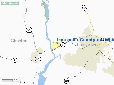
Lancaster County-mc Whirter Field Airport |
Lancaster County Airport
McWhirter Field |
| IATA: none – ICAO: KLKR – FAA LID: LKR |
| Summary |
| Airport type |
Public |
| Owner |
Lancaster County |
| Serves |
Lancaster, South Carolina |
| Elevation AMSL |
486 ft / 148 m |
| Coordinates |
34°43′22″N 080°51′17″W / 34.72278°N 80.85472°W / 34.72278; -80.85472 |
| Runways |
| Direction |
Length |
Surface |
| ft |
m |
| 6/24 |
6,004 |
1,830 |
Asphalt |
| Statistics (2009) |
| Aircraft operations |
23,850 |
| Based aircraft |
49 |
| Source: Federal Aviation Administration |
Lancaster County Airport (ICAO: KLKR, FAA LID: LKR), also known as McWhirter Field, is a county-owned, public-use airport located four nautical miles (7 km) west of the central business district of Lancaster, in Lancaster County, South Carolina, United States.
Although most U.S. airports use the same three-letter location identifier for the FAA and IATA, this airport is assigned LKR by the FAA but has no designation from the IATA (which assigned LKR to Las Khoreh in Somalia).
Facilities and aircraft
Lancaster County Airport covers an area of 301 acres (122 ha) at an elevation of 486 feet (148 m) above mean sea level. It has one runway designated 6/24 with an asphalt surface measuring 6,004 by 100 feet (1,830 x 30 m).
For the 12-month period ending July 22, 2009, the airport had 23,850 aircraft operations, an average of 65 per day: 97% general aviation, 2% air taxi, and 1% military. At that time there were 49 single-engine aircraft based at this airport.
Lancaster County Airport is operated by Lancaster Aviation and provides fuel, maintenance and a terminal facility.
The above content comes from Wikipedia and is published under free licenses – click here to read more.
Location & QuickFacts
| FAA Information Effective: | 2008-09-25 |
| Airport Identifier: | LKR |
| Airport Status: | Operational |
| Longitude/Latitude: | 080-51-15.9916W/34-43-22.7221N
-80.854442/34.722978 (Estimated) |
| Elevation: | 486 ft / 148.13 m (Surveyed) |
| Land: | 301 acres |
| From nearest city: | 4 nautical miles W of Lancaster, SC |
| Location: | Lancaster County, SC |
| Magnetic Variation: | 07W (2000) |
Owner & Manager
| Ownership: | Publicly owned |
| Owner: | Lancaster County |
| Address: | P.o.box 1809
Lancaster, SC 29721 |
| Phone number: | 803-285-1565 |
| Manager: | Gary L. Laubscher |
| Address: | 296 Aviation Blvd
Lancaster, SC 29720 |
| Phone number: | 803-285-1513 |
Airport Operations and Facilities
| Airport Use: | Open to public |
| Wind indicator: | Yes |
| Segmented Circle: | Yes |
| Control Tower: | No |
| Lighting Schedule: | DUSK-DAWN
ACTVT MIRL RY 06/24 - CTAF. |
| Beacon Color: | Clear-Green (lighted land airport) |
| Landing fee charge: | No |
| Sectional chart: | Charlotte |
| Region: | ASO - Southern |
| Boundary ARTCC: | ZTL - Atlanta |
| Tie-in FSS: | AND - Anderson |
| FSS on Airport: | No |
| FSS Toll Free: | 1-800-WX-BRIEF |
| NOTAMs Facility: | AND (NOTAM-d service avaliable) |
| Federal Agreements: | NGY |
Airport Communications
| CTAF: | 122.725 |
| Unicom: | 122.725 |
Airport Services
| Fuel available: | 100LLA |
| Airframe Repair: | MAJOR |
| Power Plant Repair: | MAJOR |
| Bulk Oxygen: | NONE |
Runway Information
Runway 06/24
| Dimension: | 5904 x 100 ft / 1799.5 x 30.5 m |
| Surface: | ASPH, Good Condition |
| Weight Limit: | Single wheel: 19000 lbs.
Dual wheel: 28000 lbs. |
| Edge Lights: | Medium |
| |
Runway 06 |
Runway 24 |
| Longitude: | 080-51-46.1270W | 080-50-45.8562W |
| Latitude: | 34-43-07.4850N | 34-43-37.9592N |
| Elevation: | 460.00 ft | 486.00 ft |
| Alignment: | 59 | 127 |
| Traffic Pattern: | Left | Left |
| Markings: | Non-precision instrument, Good Condition | Non-precision instrument, Good Condition |
| Crossing Height: | 47.00 ft | 43.00 ft |
| VASI: | 2-light PAPI on left side | 2-light PAPI on left side |
| Visual Glide Angle: | 3.00° | 3.00° |
| Runway End Identifier: | No | No |
| Centerline Lights: | No | No |
| Touchdown Lights: | No | No |
| Obstruction: | 137 ft tree, 3741.0 ft from runway, 369 ft left of centerline, 25:1 slope to clear | 90 ft tree, 2348.0 ft from runway, 120 ft right of centerline, 23:1 slope to clear |
|
Radio Navigation Aids
| ID |
Type |
Name |
Ch |
Freq |
Var |
Dist |
| LKR | NDB | Lancaster | | 400.00 | 07W | 0.2 nm |
| UZ | NDB | Rally | | 227.00 | 05W | 15.0 nm |
| TWL | NDB | Wesley | | 204.00 | 06W | 15.7 nm |
| DCM | NDB | Chester | | 220.00 | 06W | 17.5 nm |
| PYG | NDB | Pageland | | 270.00 | 06W | 25.5 nm |
| FDW | NDB | Winnsboro | | 414.00 | 05W | 27.7 nm |
| CDN | NDB | Camden | | 263.00 | 05W | 30.1 nm |
| GHJ | NDB | Stonia | | 260.00 | 06W | 31.9 nm |
| UOT | NDB | Union County | | 326.00 | 04W | 39.0 nm |
| HVS | NDB | Hartsville | | 341.00 | 07W | 41.0 nm |
| AFP | NDB | Anson County | | 283.00 | 07W | 42.1 nm |
| EOE | NDB | Enoree | | 278.00 | 05W | 45.9 nm |
| MMT | NDB | Mc Entire | | 427.00 | 05W | 47.4 nm |
| SLP | NDB | First River | | 417.00 | 06W | 48.6 nm |
| CQW | NDB | Cheraw | | 409.00 | 05W | 48.9 nm |
| SSC | TACAN | Shaw | 038X | | 05W | 48.8 nm |
| CLT | VOR/DME | Charlotte | 097X | 115.00 | 05W | 28.5 nm |
| CTF | VOR/DME | Chesterfield | 019X | 108.20 | 03W | 29.0 nm |
| FML | VORTAC | Fort Mill | 071X | 112.40 | 02W | 16.7 nm |
| MMT | VORTAC | Mc Entire | 079X | 113.20 | 05W | 48.1 nm |
| CLT | VOT | Charlotte | | 112.00 | | 29.9 nm |
Remarks
- 25 FT DROP; 200 FT FM THR RY 06.
- DEER ON & INVOF ARPT.
- NDB APPROACH AVBL.
Images and information placed above are from
http://www.airport-data.com/airport/LKR/
We thank them for the data!
| General Info
|
| Country |
United States
|
| State |
SOUTH CAROLINA
|
| FAA ID |
LKR
|
| Latitude |
34-43-22.500N
|
| Longitude |
080-51-16.500W
|
| Elevation |
486 feet
|
| Near City |
LANCASTER
|
We don't guarantee the information is fresh and accurate. The data may
be wrong or outdated.
For more up-to-date information please refer to other sources.
|
|


