 |
|
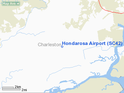
Location & QuickFacts
| FAA Information Effective: | 2008-09-25 |
| Airport Identifier: | SC42 |
| Airport Status: | Operational |
| Longitude/Latitude: | 080-06-23.0000W/32-41-13.0000N
-80.106389/32.686944 (Estimated) |
| Elevation: | 13 ft / 3.96 m (Estimated) |
| Land: | 0 acres |
| From nearest city: | 15 nautical miles NE of Charleston, SC |
| Location: | Charleston County, SC |
| Magnetic Variation: | () |
Owner & Manager
| Ownership: | Privately owned |
| Owner: | W.e. Stokes |
| Address: | 4253 Maybank Hwy
Wadmalow Island, SC 29406 |
| Phone number: | 843-559-4700 |
| Manager: | W.e. Stokes |
| Address: | 4253 Maybank Hwy
Wadmalow Island, SC 29406 |
| Phone number: | 843-559-4700 |
Airport Operations and Facilities
| Airport Use: | Private |
| Wind indicator: | Yes |
| Segmented Circle: | No |
| Control Tower: | No |
| Sectional chart: | Charlotte |
| Region: | ASO - Southern |
| Boundary ARTCC: | ZJX - Jacksonville |
| Tie-in FSS: | AND - Anderson |
| FSS Toll Free: | 1-800-WX-BRIEF |
Runway Information
Runway 17/35
| Dimension: | 3000 x 100 ft / 914.4 x 30.5 m |
| Surface: | TURF, |
| |
Runway 17 |
Runway 35 |
| Traffic Pattern: | Left | Left |
| Obstruction: | 50 ft trees, 500.0 ft from runway | |
|
Radio Navigation Aids
| ID |
Type |
Name |
Ch |
Freq |
Var |
Dist |
| JZI | NDB | Johns Island | | 283.00 | 05W | 5.2 nm |
| CH | NDB | Ashly | | 329.00 | 05W | 17.4 nm |
| DYB | NDB | Dorchester County | | 365.00 | 05W | 24.1 nm |
| MKS | NDB | Moncks Corner | | 354.00 | 05W | 30.5 nm |
| RBW | NDB | Walterboro | | 221.00 | 05W | 30.6 nm |
| NBC | TACAN | Beaufort | 042X | | 05W | 33.4 nm |
| CHS | VORTAC | Charleston | 082X | 113.50 | 05W | 12.9 nm |
| CHS | VOT | Charleston | | 111.00 | | 13.5 nm |
Remarks
Images and information placed above are from
http://www.airport-data.com/airport/SC42/
We thank them for the data!
|
|


