 |
|
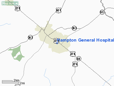
Hampton General Hospital Heliport |
Location & QuickFacts
| FAA Information Effective: | 2008-09-25 |
| Airport Identifier: | SC62 |
| Airport Status: | Operational |
| Longitude/Latitude: | 081-05-19.3790W/32-51-08.5990N
-81.088716/32.852389 (Estimated) |
| Elevation: | 86 ft / 26.21 m (Estimated) |
| Land: | 0 acres |
| From nearest city: | 1 nautical miles NW of Varnville, SC |
| Location: | Hampton County, SC |
| Magnetic Variation: | 04W (1985) |
Owner & Manager
| Ownership: | Publicly owned |
| Owner: | Hampton General Hospital |
| Address: | 503 Carolina Avenue
Varnville, SC 29944 |
| Phone number: | 803-943-2771 |
| Manager: | Dave H Hamill |
| Address: | 503 Carolina Ave
Varnville, SC 29944 |
| Phone number: | 803-943-2771 |
Airport Operations and Facilities
| Airport Use: | Private
MEDICAL USE. |
| Wind indicator: | Yes |
| Segmented Circle: | No |
| Control Tower: | No |
| Lighting Schedule: | PHONE REQ
FOR HELIPAD BEACON AND PERIMETER LGTS CALL 803-943-2771. |
| Beacon Color: | Clear-Green-Yellow (heliport) |
| Sectional chart: | Atlanta |
| Region: | ASO - Southern |
| Boundary ARTCC: | ZJX - Jacksonville |
| Tie-in FSS: | AND - Anderson |
| FSS on Airport: | No |
| FSS Toll Free: | 1-800-WX-BRIEF |
Runway Information
Helipad H1
| Dimension: | 40 x 40 ft / 12.2 x 12.2 m |
| Surface: | CONC, |
| |
Runway H1 |
Runway |
| Traffic Pattern: | Left | Left |
|
Radio Navigation Aids
| ID |
Type |
Name |
Ch |
Freq |
Var |
Dist |
| RBW | NDB | Walterboro | | 221.00 | 05W | 23.1 nm |
| JYL | NDB | Sylvania | | 245.00 | 04W | 28.3 nm |
| BKO | NDB | Barnwell | | 392.00 | 06W | 34.2 nm |
| OYI | NDB | Orangeburg | | 226.00 | 05W | 35.2 nm |
| BZ | NDB | Bullo | | 407.00 | 05W | 39.2 nm |
| DYB | NDB | Dorchester County | | 365.00 | 05W | 42.8 nm |
| LNH | NDB | Millen | | 205.00 | 05W | 44.4 nm |
| BXG | NDB | Burke County | | 356.00 | 04W | 47.6 nm |
| NBC | TACAN | Beaufort | 042X | | 05W | 29.3 nm |
| ALD | VOR | Allendale | | 116.70 | 01W | 14.1 nm |
| EDS | VOR/DME | Edisto | 051X | 111.40 | 05W | 38.1 nm |
| SAV | VORTAC | Savannah | 106Y | 115.95 | 06W | 42.8 nm |
| VAN | VORTAC | Vance | 041X | 110.40 | 06W | 49.4 nm |
| SAV | VOT | Savannah Travis Fld | | 111.00 | | 44.0 nm |
Remarks
- PRVDD ALL OPNS ARE CONDUCTED IN VFR WX CONDS; LANDING AREA IS PVT USE ONLY; ALL APCH/DEP OPNS ARE CONDUCTED FROM 032-060 AND FROM 195-225; LOA IS MAINTAINED WITH HAMPTON-VARNVILLE ARPT; WIND INDICATOR IS MAINTAINED.
Images and information placed above are from
http://www.airport-data.com/airport/SC62/
We thank them for the data!
| General Info
|
| Country |
United States
|
| State |
SOUTH CAROLINA
|
| FAA ID |
SC62
|
| Latitude |
32-51-08.599N
|
| Longitude |
081-05-19.379W
|
| Elevation |
86 feet
|
| Near City |
VARNVILLE
|
We don't guarantee the information is fresh and accurate. The data may
be wrong or outdated.
For more up-to-date information please refer to other sources.
|
|


