|
|
| Florence Regional Airport |
 |
 |
| IATA: FLO – ICAO: KFLO – FAA LID: FLO |
| Summary |
| Airport type |
Public |
| Owner |
Pee Dee Regional Airport Authority |
| Serves |
Florence, South Carolina |
| Location |
Florence County, near Florence, South Carolina |
| Elevation AMSL |
146 ft / 45 m |
| Coordinates |
34°11′07″N 079°43′26″W / 34.18528°N 79.72389°W / 34.18528; -79.72389 |
| Website |
www.FlorenceSCairport.com |
| Runways |
| Direction |
Length |
Surface |
| ft |
m |
| 1/19 |
5,999 |
1,828 |
Asphalt |
| 9/27 |
6,499 |
1,981 |
Asphalt |
| Statistics (2006) |
| Aircraft operations |
31,242 |
| Based aircraft |
52 |
| Sources: airport web site and FAA |
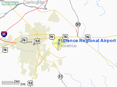
Florence Regional Airport (IATA: FLO, ICAO: KFLO, FAA LID: FLO) is a public airport located three miles (5 km) east of the central business district of Florence, a city in Florence County, South Carolina, United States.
The airport is mostly used for general aviation, but is also served by two commercial airlines. There are only two destinations served by Florence Regional, Charlotte-Douglas International Airport, and Hartsfield-Jackson Atlanta International Airport. Flights to Charlotte,NC takes approximately 30 minutes and flights to Atlanta,GA take approximately 1 hour. Facilities and aircraft
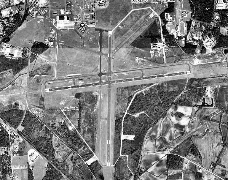
Florence Regional Airport covers an area of 1,436 acres (581 ha) which contains two asphalt paved runways: 1/19 measuring 5,999 x 150 ft (1,828 x 46 m) and 9/27 measuring 6,499 x 150 ft (1,981 x 46 m).
For the 12-month period ending December 31, 2006, the airport had 31,242 aircraft operations, an average of 85 per day: 77% general aviation, 16% air taxi and 7% military. At that time there were 52 aircraft based at this airport: 73% single-engine, 25% multi-engine and 2% jet.
Airlines and destinations
Scheduled passenger service
| Airlines |
Destinations |
| Delta Connection operated by Atlantic Southeast Airlines |
Atlanta |
| Delta Connection operated by Mesaba Airlines |
Atlanta |
| US Airways Express operated by Piedmont Airlines |
Charlotte |
History
The airport began with the purchase of 300 acres (1.2 km) of land in 1928. During World War II, the United States Army Air Forces Third Air Force used the airport as a training base and added 1,400 additional acres. Known as Florence Army Airfield, the 52d Pursuit Group was assigned to the airfield on 18 February 1942 and trained with P-39 Aircobra and P-40 Warhawks until departing on 27 April for Wilmington, North Carolina.
A succession of Troop Carrier groups trained at Florence during 1943 those being the 63d, 65th, 313th and 315th prior to their deployment to Europe and North Africa. Afterwards, the airfield became a combat crew replacement training school for A-20 Havoc light bomber crews, with the 411th Bombardment Group being the Operational Training Unit at Florence AAF from 15 August 1943 until 1 May 1944.
After the 344th was inactivated, the replacement training was taken over by the 334th Army Air Forces Base Unit (Replacement Training Unit, Light Bombardment). Support units at Florence AAF were the 407th Base Headquarters and Air Base Squadron; 10th Aviation Squadron; 958th Guard Squadron; 341st Sub-Depot; HQ, 411th Bombardment Group (Light).
In addition, Florence AAF controlled two auxiliary training bases for its A-20 Training. Those were:
- Hartsville AAF Darlington, South Carolina 34°26′45″N 79°54′00″W / 34.44583°N 79.9°W / 34.44583; -79.9
- Hartsville Auxiliary Field, Hartsville, South Carolina 34°24′00″N 80°02′30″W / 34.4°N 80.04167°W / 34.4; -80.04167
In early 1945, the airfield was transferred to First Air Force, and the 127th Army Air Forces Base unit (Combat Crew Training Station, Light) assumed the A-26 Invader training mission.
After the war the property was given back to the City of Florence on 31 October 1945, and later shared with Florence County.
Operation of the airport was assigned to the Pee Dee Regional Airport Authority in 1999. The authority had nine representatives from the Pee Dee Regional Airport District, which includes the City of Florence, and the counties of Florence, Dillon and Marion.
Florence Air & Missile Museum
From the 1960s until 1997 Florence was the home to a large aviation museum known as the Florence Air & Missile Museum. When the Museum closed the collection was divided up and transferred to various other major aviation museums in the United States.
The above content comes from Wikipedia and is published under free licenses – click here to read more.
Location & QuickFacts
| FAA Information Effective: | 2008-09-25 |
| Airport Identifier: | FLO |
| Airport Status: | Operational |
| Longitude/Latitude: | 079-43-26.0000W/34-11-07.3000N
-79.723889/34.185361 (Estimated) |
| Elevation: | 146 ft / 44.50 m (Surveyed) |
| Land: | 1436 acres |
| From nearest city: | 3 nautical miles E of Florence, SC |
| Location: | Florence County, SC |
| Magnetic Variation: | 05W (1980) |
Owner & Manager
| Ownership: | Publicly owned |
| Owner: | Pee Dee Regional Arpt Authority |
| Address: | 2100 Terminal Drive
Florence, SC 29506 |
| Phone number: | 843-669-5001 |
| Manager: | Hartsell Rogers |
| Address: | 2100 Terminal Drive
Florence, SC 29506 |
| Phone number: | 843-669-5001 |
Airport Operations and Facilities
| Airport Use: | Open to public |
| Wind indicator: | Yes |
| Segmented Circle: | Yes |
| Control Tower: | Yes |
| Lighting Schedule: | DUSK-DAWN
WHEN ATCT CLSD ACTVT HIRL RY 09/27, PAPI RYS 01, 19, 09 & 27, MALSR RY 09 AND TWY LGTS - CTAF. |
| Beacon Color: | Clear-Green (lighted land airport) |
| Landing fee charge: | No |
| Sectional chart: | Charlotte |
| Region: | ASO - Southern |
| Boundary ARTCC: | ZJX - Jacksonville |
| Tie-in FSS: | AND - Anderson |
| FSS on Airport: | No |
| FSS Toll Free: | 1-800-WX-BRIEF |
| NOTAMs Facility: | FLO (NOTAM-d service avaliable) |
| Certification type/date: | I A S 08/2005 |
| Federal Agreements: | NGRY3 |
Airport Communications
| CTAF: | 125.100 |
| Unicom: | 122.950 |
Airport Services
| Fuel available: | 100LLA |
| Airframe Repair: | MAJOR |
| Power Plant Repair: | MAJOR |
| Bottled Oxygen: | NONE |
| Bulk Oxygen: | NONE |
Runway Information
Runway 01/19
| Dimension: | 6000 x 147 ft / 1828.8 x 44.8 m |
| Surface: | ASPH, Good Condition |
| Weight Limit: | Single wheel: 65000 lbs.
Dual wheel: 100000 lbs. |
| Edge Lights: | Medium |
| |
Runway 01 |
Runway 19 |
| Longitude: | 079-43-29.3263W | 079-43-27.4665W |
| Latitude: | 34-10-33.7935N | 34-11-33.1201N |
| Elevation: | 112.00 ft | 143.00 ft |
| Alignment: | 1 | 127 |
| Traffic Pattern: | Left | Left |
| Markings: | Non-precision instrument, Good Condition | Non-precision instrument, Good Condition |
| Crossing Height: | 57.00 ft | 42.00 ft |
| VASI: | 4-light PAPI on left side | 4-light PAPI on left side |
| Visual Glide Angle: | 3.00° | 3.00° |
| Obstruction: | 42 ft tree, 1250.0 ft from runway, 25:1 slope to clear | 90 ft trees, 2000.0 ft from runway, 20:1 slope to clear |
|
Runway 09/27
| Dimension: | 6502 x 148 ft / 1981.8 x 45.1 m |
| Surface: | ASPH, Good Condition |
| Surface Treatment: | Saw-cut or plastic Grooved |
| Weight Limit: | Single wheel: 52000 lbs.
Dual wheel: 77000 lbs.
Dual tandem wheel: 135000 lbs. |
| Edge Lights: | High |
| |
Runway 09 |
Runway 27 |
| Longitude: | 079-44-02.1971W | 079-42-45.2979W |
| Latitude: | 34-11-07.2484N | 34-11-14.4725N |
| Elevation: | 146.00 ft | 121.00 ft |
| Alignment: | 84 | 127 |
| ILS Type: | ILS
| |
| Traffic Pattern: | Left | Left |
| Markings: | Precision instrument, Good Condition | Non-precision instrument, Good Condition |
| Crossing Height: | 58.00 ft | 46.00 ft |
| VASI: | 4-light PAPI on left side | 4-light PAPI on left side |
| Visual Glide Angle: | 3.00° | 3.00° |
| Approach lights: | MALSR | |
|
Radio Navigation Aids
| ID |
Type |
Name |
Ch |
Freq |
Var |
Dist |
| UDG | NDB | Darlington | | 245.00 | 06W | 17.5 nm |
| MAO | NDB | Marion | | 388.00 | 06W | 19.4 nm |
| CFY | NDB | Evans | | 420.00 | 06W | 19.9 nm |
| HVS | NDB | Hartsville | | 341.00 | 07W | 23.7 nm |
| DLC | NDB | Dillon | | 274.00 | 05W | 23.7 nm |
| BES | NDB | Bennettsville | | 230.00 | 07W | 26.1 nm |
| CKI | NDB | Kingstree | | 404.00 | 06W | 28.9 nm |
| HEK | NDB | Stuckey | | 236.00 | 06W | 29.2 nm |
| SMS | NDB | Sumter | | 252.00 | 04W | 33.8 nm |
| CQW | NDB | Cheraw | | 409.00 | 05W | 34.2 nm |
| ME | NDB | Maxtn | | 257.00 | 08W | 35.8 nm |
| JB | NDB | Jigel | | 384.00 | 08W | 36.2 nm |
| HYW | NDB | Horry | | 370.00 | 08W | 36.8 nm |
| RCZ | NDB | Roscoe | | 375.00 | 07W | 40.1 nm |
| RSY | NDB | Robeson | | 359.00 | 08W | 41.8 nm |
| CDN | NDB | Camden | | 263.00 | 05W | 42.0 nm |
| MNI | NDB | Manning | | 381.00 | 06W | 43.2 nm |
| PHH | NDB | Andrews | | 255.00 | 06W | 45.2 nm |
| PYG | NDB | Pageland | | 270.00 | 06W | 45.4 nm |
| SSC | TACAN | Shaw | 038X | | 05W | 39.0 nm |
| LBT | VOR | Lumberton | | 110.00 | 08W | 41.9 nm |
| CTF | VOR/DME | Chesterfield | 019X | 108.20 | 03W | 39.1 nm |
| FLO | VORTAC | Florence | 099X | 115.20 | 03W | 4.4 nm |
Remarks
- 12 HR PPR FOR UNSKED ACR OPNS WITH MORE THAN 30 PSGR SEATS; CTC AMGR AT 843-669-5001.
- 442 FT LIGHTED CRANE 2 MILES NW OF ARPT.
- EXISTED PRIOR TO 1958.
Images and information placed above are from
http://www.airport-data.com/airport/FLO/
We thank them for the data!
| General Info
|
| Country |
United States
|
| State |
SOUTH CAROLINA
|
| FAA ID |
FLO
|
| Latitude |
34-11-07.300N
|
| Longitude |
079-43-26.000W
|
| Elevation |
146 feet
|
| Near City |
FLORENCE
|
We don't guarantee the information is fresh and accurate. The data may
be wrong or outdated.
For more up-to-date information please refer to other sources.
|
|