 |
|
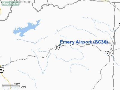
Location & QuickFacts
| FAA Information Effective: | 2008-09-25 |
| Airport Identifier: | SC36 |
| Airport Status: | Operational |
| Longitude/Latitude: | 082-19-35.0000W/35-07-29.0000N
-82.326389/35.124722 (Estimated) |
| Elevation: | 1220 ft / 371.86 m (Estimated) |
| Land: | 0 acres |
| From nearest city: | 12 nautical miles NW of Greer, SC |
| Location: | Greenville County, SC |
| Magnetic Variation: | 04W (1990) |
Owner & Manager
| Ownership: | Privately owned |
| Owner: | Arnold Emery |
| Address: | 1909 Hwy 11
Landrum, SC 29356 |
| Phone number: | 803-895-3265 |
| Manager: | Arnold Emery |
| Address: | 1909 Hwy 11
Landrum, SC 29356 |
| Phone number: | 803-895-3265 |
Airport Operations and Facilities
| Airport Use: | Private |
| Segmented Circle: | No |
| Control Tower: | No |
| Sectional chart: | Charlotte |
| Region: | ASO - Southern |
| Boundary ARTCC: | ZTL - Atlanta |
| Tie-in FSS: | AND - Anderson |
| FSS Toll Free: | 1-800-WX-BRIEF |
Runway Information
Runway 03/21
| Dimension: | 1900 x 28 ft / 579.1 x 8.5 m |
| Surface: | ASPH, |
| |
Runway 03 |
Runway 21 |
| Traffic Pattern: | Left | Left |
|
Radio Navigation Aids
| ID |
Type |
Name |
Ch |
Freq |
Var |
Dist |
| BRA | NDB | Broad River | | 379.00 | 04W | 11.4 nm |
| FRT | NDB | Fairmont | | 248.00 | 05W | 21.5 nm |
| RFE | NDB | Rutherford | | 344.00 | 05W | 22.8 nm |
| LQK | NDB | Lake Keowee | | 408.00 | 04W | 26.5 nm |
| GY | NDB | Dyana | | 338.00 | 03W | 26.7 nm |
| SLP | NDB | First River | | 417.00 | 06W | 36.6 nm |
| CEU | NDB | Clemson | | 257.00 | 05W | 38.7 nm |
| LUX | NDB | Laurens | | 307.00 | 04W | 41.5 nm |
| AND | NDB | Anderson County | | 230.00 | 04W | 42.1 nm |
| UOT | NDB | Union County | | 326.00 | 04W | 42.9 nm |
| FIQ | NDB | Fiddlers | | 391.00 | 07W | 47.6 nm |
| SUG | VORTAC | Sugarloaf Mountain | 059X | 112.20 | 02W | 17.2 nm |
| SPA | VORTAC | Spartanburg | 104X | 115.70 | 02W | 20.4 nm |
| ELW | VORTAC | Electric City | 023X | 108.60 | 00E | 48.1 nm |
Remarks
- OPERS CONDUCTED VFR CONDS; USE BY OWNER ONLY.
Images and information placed above are from
http://www.airport-data.com/airport/SC36/
We thank them for the data!
| General Info
|
| Country |
United States
|
| State |
SOUTH CAROLINA
|
| FAA ID |
SC36
|
| Latitude |
35-07-29.000N
|
| Longitude |
082-19-35.000W
|
| Elevation |
1220 feet
|
| Near City |
GREER
|
We don't guarantee the information is fresh and accurate. The data may
be wrong or outdated.
For more up-to-date information please refer to other sources.
|
|


