|
|
| Donaldson Center Airport |
 |
| IATA: GDC – ICAO: KGYH – FAA LID: GYH |
| Summary |
| Airport type |
Public |
| Owner |
Greenville City/County |
| Serves |
Greenville, South Carolina |
| Elevation AMSL |
955 ft / 291 m |
| Coordinates |
34°45′30″N 082°22′35″W / 34.75833°N 82.37639°W / 34.75833; -82.37639 |
| Website |
www.DonaldsonCenter.com/... |
| Runways |
| Direction |
Length |
Surface |
| ft |
m |
| 5/23 |
8,000 |
2,438 |
Concrete |
| Statistics (2005) |
| Aircraft operations |
45,375 |
| Based aircraft |
83 |
| Source: Federal Aviation Administration |
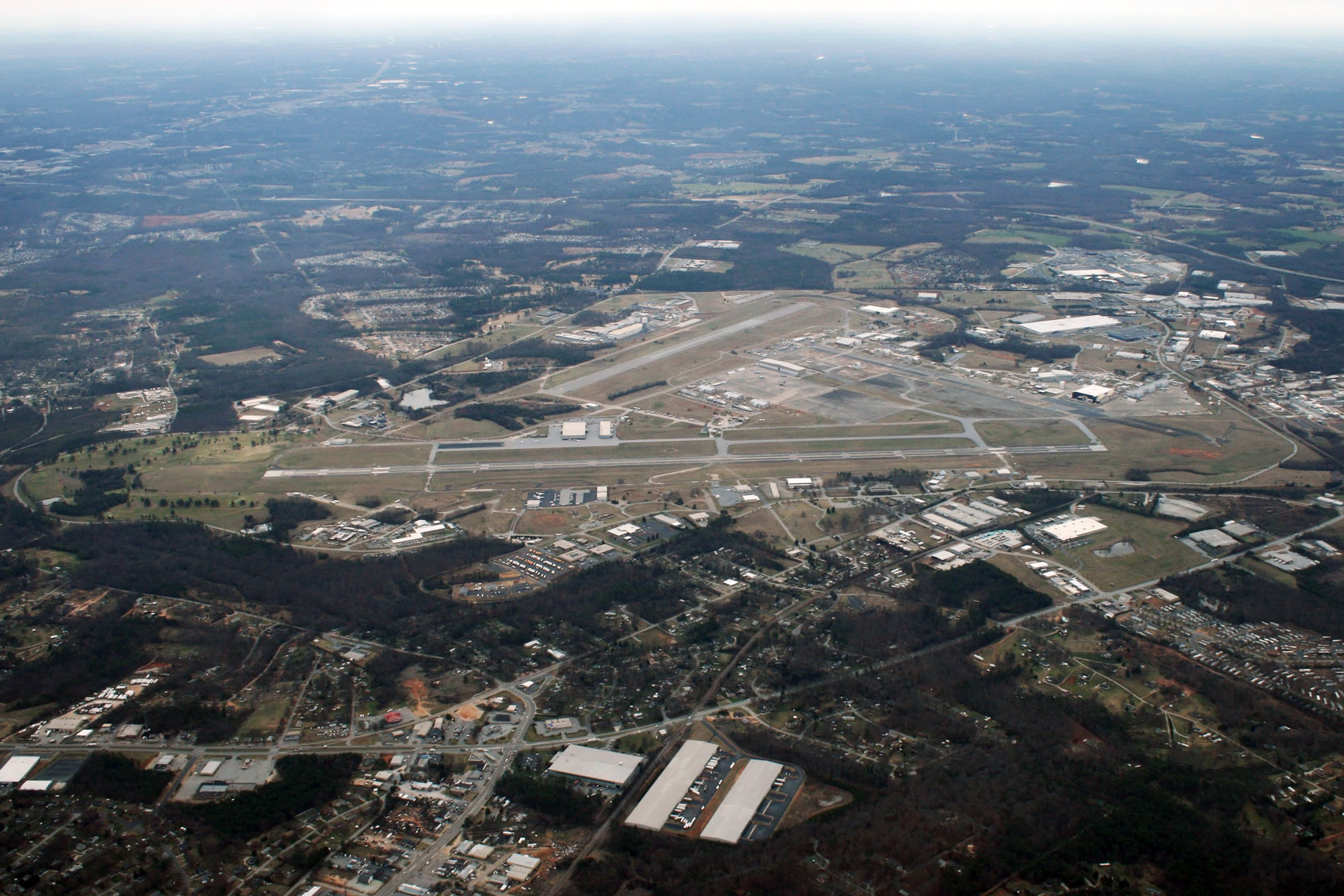
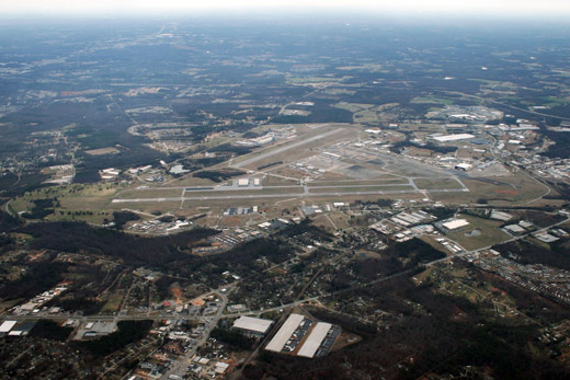
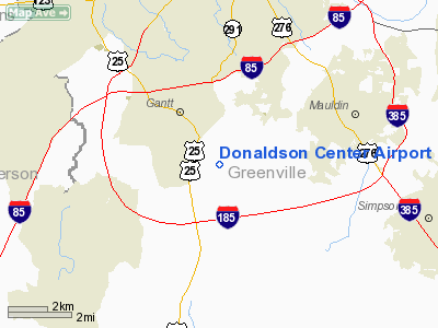
Donaldson Center Airport (IATA: GDC, ICAO: KGYH, FAA LID: GYH) is a public airport six miles (10 km) south of the central business district of Greenville, a city in Greenville County, South Carolina, United States. It located at the Donaldson Center Industrial Air Park and is owned by the City and County of Greenville.
Although most U.S. airports use the same three-letter location identifier for the FAA and IATA, Donaldson Center Airport is assigned GYH by the FAA and GDC by the IATA. HistoryGreenville Army Air Base opened in 1942 during World War II. It was later known as Greenville Air Force Base. In 1951 it was renamed Donaldson Air Force Base, in honor of Captain John O. Donaldson, a Greenville native and World War I flying ace. The U.S. Air Force announced Donaldson's closure in 1962. The City and County of Greenville took title of the facilities in 1964 and named it Donaldson Center Industrial Air Park.
Facilities and aircraft
Donaldson Center Airport covers an area of 1,300 acres (526 ha) which contains one runway designated 5/23 with 8,000 x 150 ft (2,438 x 46 m) concrete pavement. For the 12-month period ending October 31, 2005, the airport had 45,375 aircraft operations, an average of 124 per day: 84% general aviation, 10% air taxi and 6% military. At that time there were 83 aircraft based at this airport: 80% single-engine, 14% multi-engine and 6% jet.
The above content comes from Wikipedia and is published under free licenses – click here to read more.
Location & QuickFacts
| FAA Information Effective: | 2008-09-25 |
| Airport Identifier: | GYH |
| Airport Status: | Operational |
| Longitude/Latitude: | 082-22-35.0940W/34-45-29.9490N
-82.376415/34.758319 (Estimated) |
| Elevation: | 955 ft / 291.08 m (Surveyed) |
| Land: | 1300 acres |
| From nearest city: | 6 nautical miles S of Greenville, SC |
| Location: | Greenville County, SC |
| Magnetic Variation: | 04W (1985) |
Owner & Manager
| Ownership: | Publicly owned |
| Owner: | Greenville City/county |
| Address: | 2 Exchange St
Greenville, SC 29605 |
| Phone number: | 864-277-3152 |
| Manager: | Peter Cevallos |
| Address: | 2 Exchange St
Greenville, SC 29605 |
| Phone number: | 864-277-3152 |
Airport Operations and Facilities
| Airport Use: | Open to public |
| Wind indicator: | Yes |
| Segmented Circle: | Yes |
| Control Tower: | Yes |
| Lighting Schedule: | DUSK-DAWN
ACTVT HIRL RY 05/23, PAPI RYS 05 & 23, MALSR RY 05 - CTAF. |
| Beacon Color: | Clear-Green (lighted land airport) |
| Landing fee charge: | No |
| Sectional chart: | Atlanta |
| Region: | ASO - Southern |
| Traffic Pattern Alt: | 800 ft |
| Boundary ARTCC: | ZTL - Atlanta |
| Tie-in FSS: | AND - Anderson |
| FSS on Airport: | No |
| FSS Toll Free: | 1-800-WX-BRIEF |
| NOTAMs Facility: | GYH (NOTAM-d service avaliable) |
| Certification type/date: | IV A U 09/198
CLSD TO ACR OPNS WITH MORE THAN 30 PSGR SEATS EXCP 24 HR PPR CALL AMGR 864-277-3152. |
| Federal Agreements: | NGY |
Airport Communications
| CTAF: | 133.325 |
| Unicom: | 122.700 |
Airport Services
| Fuel available: | 100LLA |
| Airframe Repair: | MAJOR |
| Power Plant Repair: | MAJOR |
| Bottled Oxygen: | NONE |
| Bulk Oxygen: | HIGH |
Runway Information
Runway 05/23
| Dimension: | 8000 x 150 ft / 2438.4 x 45.7 m |
| Surface: | CONC, Good Condition |
| Surface Treatment: | Saw-cut or plastic Grooved |
| Weight Limit: | Single wheel: 30000 lbs.
Dual wheel: 120000 lbs.
Dual tandem wheel: 200000 lbs. |
| Edge Lights: | High |
| |
Runway 05 |
Runway 23 |
| Longitude: | 082-23-05.8900W | 082-22-04.2900W |
| Latitude: | 34-44-59.6300N | 34-46-00.2700N |
| Elevation: | 955.00 ft | 918.00 ft |
| Alignment: | 40 | 127 |
| ILS Type: | ILS/DME
| |
| Traffic Pattern: | Right | Left |
| Markings: | Precision instrument, Good Condition | Precision instrument, Good Condition |
| Crossing Height: | 60.00 ft | 80.00 ft |
| VASI: | 4-light PAPI on left side | 4-light PAPI on left side |
| Visual Glide Angle: | 3.22° | 4.14° |
| Approach lights: | MALSR | |
| Runway End Identifier: | No | |
| Obstruction: | , 50:1 slope to clear | 42 ft trees, 1600.0 ft from runway, 650 ft left of centerline, 33:1 slope to clear |
|
Radio Navigation Aids
| ID |
Type |
Name |
Ch |
Freq |
Var |
Dist |
| GY | NDB | Dyana | | 338.00 | 03W | 5.2 nm |
| LQK | NDB | Lake Keowee | | 408.00 | 04W | 16.5 nm |
| FRT | NDB | Fairmont | | 248.00 | 05W | 21.2 nm |
| AND | NDB | Anderson County | | 230.00 | 04W | 22.7 nm |
| CEU | NDB | Clemson | | 257.00 | 05W | 25.7 nm |
| LUX | NDB | Laurens | | 307.00 | 04W | 25.9 nm |
| BRA | NDB | Broad River | | 379.00 | 04W | 31.3 nm |
| GIW | NDB | Coronaca | | 239.00 | 04W | 33.6 nm |
| UOT | NDB | Union County | | 326.00 | 04W | 36.5 nm |
| RFE | NDB | Rutherford | | 344.00 | 05W | 41.2 nm |
| EOE | NDB | Enoree | | 278.00 | 05W | 45.4 nm |
| SLP | NDB | First River | | 417.00 | 06W | 48.5 nm |
| SPA | VORTAC | Spartanburg | 104X | 115.70 | 02W | 27.7 nm |
| ELW | VORTAC | Electric City | 023X | 108.60 | 00E | 28.7 nm |
| GRD | VORTAC | Greenwood | 102X | 115.50 | 01W | 32.4 nm |
| SUG | VORTAC | Sugarloaf Mountain | 059X | 112.20 | 02W | 39.3 nm |
| ODF | VORTAC | Foothills | 081X | 113.40 | 00E | 45.7 nm |
Remarks
Images and information placed above are from
http://www.airport-data.com/airport/GYH/
We thank them for the data!
| General Info
|
| Country |
United States
|
| State |
SOUTH CAROLINA
|
| FAA ID |
GYH
|
| Latitude |
34-45-29.949N
|
| Longitude |
082-22-35.094W
|
| Elevation |
955 feet
|
| Near City |
GREENVILLE
|
We don't guarantee the information is fresh and accurate. The data may
be wrong or outdated.
For more up-to-date information please refer to other sources.
|
|