 |
|
Darlington County Jetport Airport |
| Darlington County Jetport |
 |
| IATA: UDG – ICAO: KUDG |
| Summary |
| Airport type |
Public |
| Owner |
Public |
| Operator |
Darlington County |
| Serves |
Darlington, South Carolina |
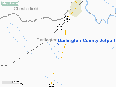
| Location |
Darlington County, near Society Hill, South Carolina |
| Elevation AMSL |
192 ft / 58.5 m |
| Coordinates |
34°26′57.7841″N 079°53′24.2190″W / 34.449384472°N 79.89006083°W / 34.449384472; -79.89006083Coordinates: 34°26′57.7841″N 079°53′24.2190″W / 34.449384472°N 79.89006083°W / 34.449384472; -79.89006083 |
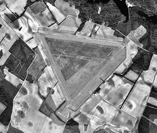
| Runways |
| Direction |
Length |
Surface |
| ft |
m |
| 5/23 |
5,500 |
1,676 |
Asphalt |
| 10/28 |
4,947 |
1,508 |
Asphalt |
| 16/34 |
4,751 |
1,448 |
Asphalt |
Darlington County Jetport (IATA: UDG, ICAO: KUDG) is a public airport located 9 miles north of Darlington, South Carolina. The airport serves the general aviation community, with no scheduled commercial airline service. History
The airport was opened in October 1943. It was built by the United States Army Air Force, and known as Hartsville Army Airfield. It was used as an auxiliary training base for Florence Army Airfield, located 18 miles southeast. It was built as a bomber airfield, and supported A-20 Havocs, and later A-26 Invaders which were based at Florence. It's base unit was the 82d Station Compliment Squadron, which maintained the airfield and provided service to the aircrart.
The military use of the airfield ended early in 1945, and was turned over to civil authorities which converted it into a civil airport.
The above content comes from Wikipedia and is published under free licenses – click here to read more.
Location & QuickFacts
| FAA Information Effective: | 2008-09-25 |
| Airport Identifier: | UDG |
| Airport Status: | Operational |
| Longitude/Latitude: | 079-53-24.2190W/34-26-57.7841N
-79.890061/34.449384 (Estimated) |
| Elevation: | 192 ft / 58.52 m (Surveyed) |
| Land: | 635 acres |
| From nearest city: | 9 nautical miles N of Darlington, SC |
| Location: | Darlington County, SC |
| Magnetic Variation: | 06W (1985) |
Owner & Manager
| Ownership: | Publicly owned |
| Owner: | Darlington County |
| Address: | County Courthouse
Darlington, SC 29532 |
| Phone number: | 843-393-1000 |
| Manager: | Tim Parker
FBO MANAGER TIM PARKER CAN BE REACHED AT 843-393-2987. |
| Address: | 433 Quiet Brook Road
Darlington, SC 29540 |
| Phone number: | 843-393-2987 |
Airport Operations and Facilities
| Airport Use: | Open to public |
| Wind indicator: | Yes |
| Segmented Circle: | Yes |
| Control Tower: | No |
| Lighting Schedule: | DUSK-DAWN
TWY LGTS OPER & MIRL RY 05/23 ARE PRESET LOW INTST DUSK-2300; TO INCR INTST - CTAF. AFTER 2300, ACTVT MIRL 05/23 & TWY LGTS - CTAF. ACTVT REIL RYS 05 & 23 - CTAF. |
| Beacon Color: | Clear-Green (lighted land airport) |
| Landing fee charge: | No |
| Sectional chart: | Charlotte |
| Region: | ASO - Southern |
| Boundary ARTCC: | ZJX - Jacksonville |
| Tie-in FSS: | AND - Anderson |
| FSS on Airport: | No |
| FSS Toll Free: | 1-800-WX-BRIEF |
| NOTAMs Facility: | UDG (NOTAM-d service avaliable) |
| Federal Agreements: | NGY3 |
Airport Communications
| CTAF: | 123.000 |
| Unicom: | 123.000 |
Airport Services
| Fuel available: | 100LLA |
| Airframe Repair: | MAJOR |
| Power Plant Repair: | NONE |
| Bottled Oxygen: | NONE |
| Bulk Oxygen: | NONE |
Runway Information
Runway 05/23
| Dimension: | 5500 x 100 ft / 1676.4 x 30.5 m |
| Surface: | ASPH, Good Condition
RY 10/28 PAVEMENT CRACKING SEVERELY. GRASS GROWING THROUGH CRACKS ENTIRE RUNWAY.
RY 16/34 HAS SEVERE CRACKING WITH GRASS GROWING THROUGH CRACKS ENTIRE RY. |
| Weight Limit: | Single wheel: 25000 lbs. |
| Edge Lights: | Medium |
| |
Runway 05 |
Runway 23 |
| Longitude: | 079-53-33.7886W | 079-52-48.4630W |
| Latitude: | 34-26-31.2731N | 34-27-10.6448N |
| Elevation: | 188.00 ft | 183.00 ft |
| Alignment: | 43 | 127 |
| Traffic Pattern: | Left | Left |
| Markings: | Non-precision instrument, Good Condition | Non-precision instrument, Good Condition |
| Crossing Height: | 52.00 ft | 55.00 ft |
| VASI: | 2-light PAPI on left side | 2-light PAPI on left side |
| Visual Glide Angle: | 3.00° | 3.00° |
| Approach lights: | ODALS | |
| Runway End Identifier: | Yes | Yes |
| Obstruction: | 63 ft , 2750.0 ft from runway, 27 ft left of centerline, 40:1 slope to clear | 58 ft tree, 1362.0 ft from runway, 200 ft left of centerline, 21:1 slope to clear |
|
Runway 10/28
| Dimension: | 4947 x 150 ft / 1507.8 x 45.7 m |
| Surface: | ASPH, Poor Condition
RY 10/28 PAVEMENT CRACKING SEVERELY. GRASS GROWING THROUGH CRACKS ENTIRE RUNWAY.
RY 16/34 HAS SEVERE CRACKING WITH GRASS GROWING THROUGH CRACKS ENTIRE RY. |
| Weight Limit: | Single wheel: 25000 lbs. |
| |
Runway 10 |
Runway 28 |
| Longitude: | 079-53-52.4715W | 079-52-53.9995W |
| Latitude: | 34-27-13.8705N | 34-27-06.9039N |
| Elevation: | 192.00 ft | 184.00 ft |
| Alignment: | 98 | 127 |
| Traffic Pattern: | Left | Left |
| Markings: | Basic, Poor Condition
MARKINGS OBSTRUCTED BY GRASS GROWING THROUGH CRACKS IN PAVEMENT. | Basic, Poor Condition
RY 10/28 MARKINGS ARE NOT VISIBLE THROUGH GRASS GROWING THROUGH CRACKS IN PAVEMENT. |
| Obstruction: | 58 ft tree, 407.0 ft from runway, 214 ft right of centerline, 3:1 slope to clear | 89 ft tree, 2000.0 ft from runway, 275 ft left of centerline, 20:1 slope to clear |
|
Runway 16/34
| Dimension: | 4751 x 150 ft / 1448.1 x 45.7 m |
| Surface: | ASPH, Poor Condition
RY 10/28 PAVEMENT CRACKING SEVERELY. GRASS GROWING THROUGH CRACKS ENTIRE RUNWAY.
RY 16/34 HAS SEVERE CRACKING WITH GRASS GROWING THROUGH CRACKS ENTIRE RY. |
| Weight Limit: | Single wheel: 25000 lbs. |
| |
Runway 16 |
Runway 34 |
| Longitude: | 079-53-51.6390W | 079-53-29.1621W |
| Latitude: | 34-27-14.1361N | 34-26-30.9884N |
| Elevation: | 192.00 ft | 187.00 ft |
| Alignment: | 127 | 127 |
| Traffic Pattern: | Left | Left |
| Markings: | Basic, Poor Condition
GRASS HAS MARKINGS OBSCURED. | Basic, Poor Condition
GRASS HAS RUNWAY MARKINGS OBSCRUED. |
| Obstruction: | 89 ft tree, 2000.0 ft from runway, 275 ft left of centerline, 20:1 slope to clear | 71 ft tree, 1296.0 ft from runway, 139 ft right of centerline, 15:1 slope to clear
RY 34 APCH SLOPE 22:1 AT DSPLCD THLD. |
|
Radio Navigation Aids
| ID |
Type |
Name |
Ch |
Freq |
Var |
Dist |
| UDG | NDB | Darlington | | 245.00 | 06W | 0.4 nm |
| HVS | NDB | Hartsville | | 341.00 | 07W | 11.7 nm |
| BES | NDB | Bennettsville | | 230.00 | 07W | 12.9 nm |
| CQW | NDB | Cheraw | | 409.00 | 05W | 17.6 nm |
| DLC | NDB | Dillon | | 274.00 | 05W | 25.8 nm |
| RCZ | NDB | Roscoe | | 375.00 | 07W | 26.1 nm |
| ME | NDB | Maxtn | | 257.00 | 08W | 27.9 nm |
| PYG | NDB | Pageland | | 270.00 | 06W | 28.4 nm |
| MAO | NDB | Marion | | 388.00 | 06W | 31.9 nm |
| CDN | NDB | Camden | | 263.00 | 05W | 34.8 nm |
| AFP | NDB | Anson County | | 283.00 | 07W | 35.8 nm |
| SMS | NDB | Sumter | | 252.00 | 04W | 36.1 nm |
| CFY | NDB | Evans | | 420.00 | 06W | 36.2 nm |
| JB | NDB | Jigel | | 384.00 | 08W | 37.7 nm |
| HFF | NDB | Mackall | | 278.00 | 06W | 40.1 nm |
| RSY | NDB | Robeson | | 359.00 | 08W | 42.3 nm |
| CKI | NDB | Kingstree | | 404.00 | 06W | 44.0 nm |
| HEK | NDB | Stuckey | | 236.00 | 06W | 47.0 nm |
| SSC | TACAN | Shaw | 038X | | 05W | 40.3 nm |
| LBT | VOR | Lumberton | | 110.00 | 08W | 42.5 nm |
| CTF | VOR/DME | Chesterfield | 019X | 108.20 | 03W | 22.6 nm |
| FLO | VORTAC | Florence | 099X | 115.20 | 03W | 17.4 nm |
| SDZ | VORTAC | Sandhills | 055X | 111.80 | 03W | 48.4 nm |
Remarks
- ARPT EXISTED PRIOR TO 1958
Images and information placed above are from
http://www.airport-data.com/airport/UDG/
We thank them for the data!
| General Info
|
| Country |
United States
|
| State |
SOUTH CAROLINA
|
| FAA ID |
UDG
|
| Latitude |
34-26-57.100N
|
| Longitude |
079-53-25.300W
|
| Elevation |
192 feet
|
| Near City |
DARLINGTON
|
We don't guarantee the information is fresh and accurate. The data may
be wrong or outdated.
For more up-to-date information please refer to other sources.
|
|


