|
 |
|
||||
|
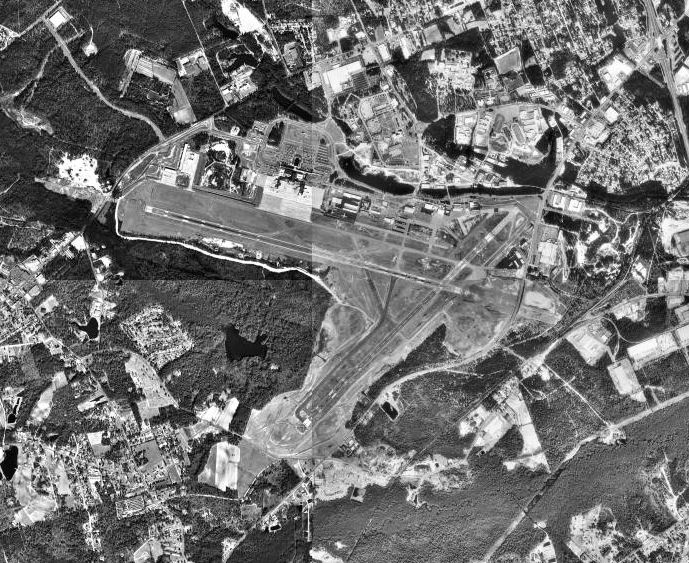
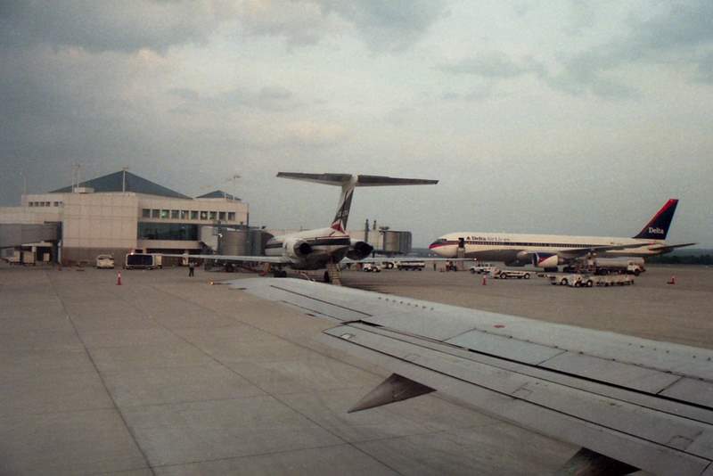
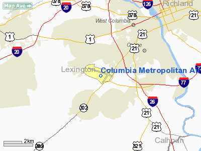
Columbia Metropolitan Airport (IATA: CAE, ICAO: KCAE, FAA LID: CAE) is the main airport for Columbia, South Carolina. The airport lies five miles (8 km) southwest of Columbia's central business district, in Lexington County. Airlines and destinationsPassenger service is provided by seven scheduled airlines, with commercial cargo service being handled by three scheduled airlines and numerous air freight operators. Two fixed-base operators also serve the Metro facility with various charter flights. The airport maintains a newly dedicated air cargo terminal, the Columbia Airport Enterprise Park (CAE Park) and Foreign Trade Zone #127. Columbia Metropolitan Airport recently completed a $45 million terminal expansion and renovation. Annually, the airport serves more than 1.2 million passengers and processes more than 168,000 tons of air cargo. Scheduled passenger service
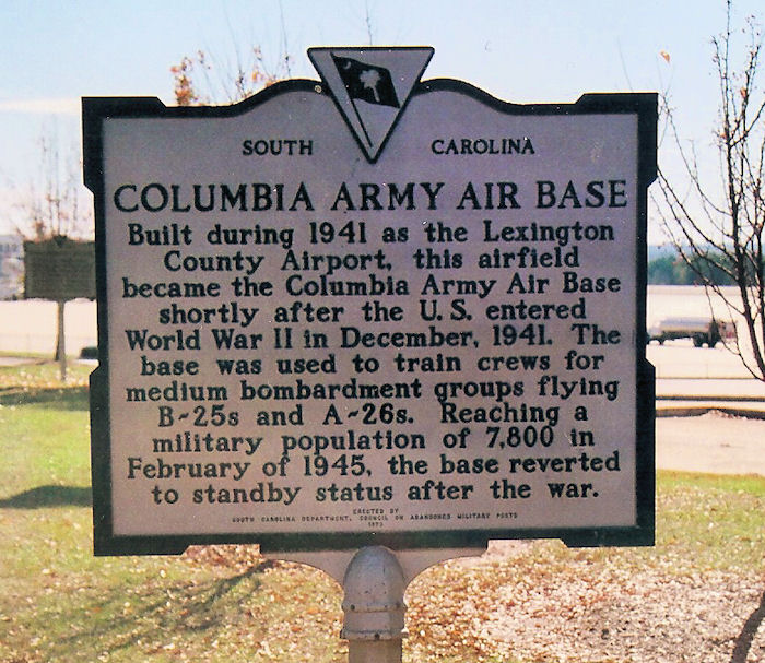
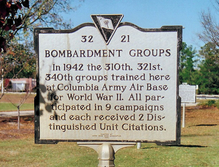
UPS Southeastern Regional HubIn August 1996, United Parcel Service opened an $80 million Southeastern Regional Hub at the airport. The hub offers next day, second day and third day air service. The buildings encompass 352,000 square feet (32,700 m) and the 44 acre ramp is large enough to hold 22 DC-8 aircraft. The hub can process 42,000 packages an hour. Other major air cargo companies serving the airport include ABX Air and FedEx Express. Facilities and aircraftColumbia Metropolitan Airport covers an area of 2,600 acres (1,052 ha) which contains two runways: 11/29 measuring 8,601 x 150 ft (2,622 x 46 m) and 5/23 measuring 8,001 x 150 ft (2,439 x 46 m). It also has a 50 x 50 ft (15 x 15 m) helipad. For the 12-month period ending December 31, 2006, the airport had 98,239 aircraft operations, an average of 269 per day: 47% air taxi, 38% general aviation, 11% scheduled commercial and 4% military. At that time there were 100 aircraft based at this airport: 60% single-engine, 25% multi-engine, 14% jet and 1% military. ServicesThe Airport hosts several services, including a gift shop, the Everett Adams Memorial chapel, a Columbia City Police precinct, restaurants and bars inside the terminal, and an eatery. Free wireless Internet service is provided throughout the airport as well as small number of recharge stations with access to outlets. HistoryThe airport was constructed in the 1940 as Lexington County Airport. In 1940 the United States Army Air Corps indicated a need for the airfield as part of the buildup of its forces after World War II began in Europe. The earliest recorded Air Corps use of the airport was when the 105th Observation Squadron began flying Douglas O-38 and North American O-47 light observation aircraft beginning on 24 September. In 1941, the airport came under formal military control and an immediate construction program began to turn the civil airport into a military airfield. Construction involved runways and airplane hangars, with three concrete runways, several taxiways and a large parking apron and a control tower. Several large hangars were also constructed. Buildings were ultimately utilitarian and quickly assembled. Most base buildings, not meant for long-term use, were constructed of temporary or semi-permanent materials. Although some hangars had steel frames and the occasional brick or tile brick building could be seen, most support buildings sat on concrete foundations but were of frame construction clad in little more than plywood and tar paper. While under construction, the 65th Observation Group used the unfinished facilities at the airfield between 1 September and 1 December 1941, flying a mixture O-47s, O-49 Vigilant and O-52 Owl light observation planes as part of the "Carolina Maneuvers" in the Fall of 1941 performing reconnaissance and aerial photo duties. On 8 December 1941, the Columbia Army Airbase was activated with Lt. Colonel Dashe W. Reeves as commander. It was assigned to Third Air Force, III Air Support Command. The 121st Observation Squadron was moved to the new air base from nearby Owens Field, replacing the 105th OS which was sent to Langley Field, Virginia and the Marine Corps airfield at Cherry Point North Carolina to fly antisubmarine patrols. The 121st OS, which had also been flying observation flights as part of the "Carolina Maneuvers", began antisubmarine patrols over the Atlantic coast using O-47s and L-4 Grasshoppers. The 96th Air Base Squadron was initially assigned as the base host unit for ground support squadrons, being replaced by the 19th Air Base Group in February 1942. The antisubmarine patrol mission was reassigned to Charleston AAF which was much better suited for it, as Charleston was located right on the Atlantic coast. Columbia Army Airfield's mission was changed become a training base for B-25 Mitchell medium bomber aircrews. In addition to the main facility, Columbia AAB had jurisdiction over several satellite and auxiliary airfields in support of the bomber training mission:
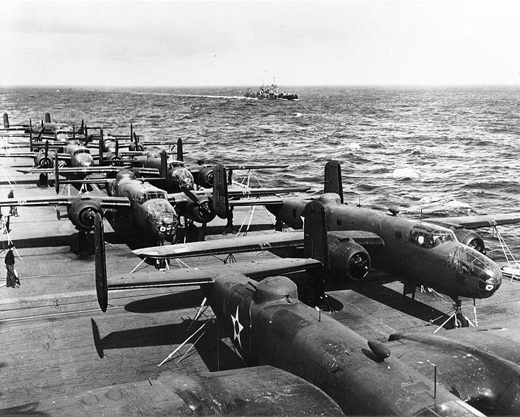
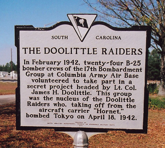
One of the earliest units to train at Columbia AAB was the 17th Bombardment Group, which arrived on 9 February 1942. The squadrons of the 17th Bomb group came to Columbia AAB from Pendleton Field, Oregon to fly antisubmarine patrols off the east coast of the United States. When the group arrived in Columbia its combat crews were offered the opportunity to volunteer for an "extremely hazardous" but unspecified mission which ultimately turned out to be the famous Doolittle Raid on Japan. On 17 February, 24 full combat crews from amongst the group were detached from Eighth Air Force and transferred to Eglin Field, Florida where they received intensive training for three weeks in simulated carrier deck takeoffs, low-level and night flying, low altitude bombing, and over water navigation. Contrary to popular belief, the volunteers who made up the crews of the Doolittle Raid did not train for the Raid itself at Columbia. The 21st Bombardment Group became the B-25 Operational training unit at Columbia on 21 April 1942, until the unit was reassigned organizationally to Key Field, Mississippi on 22 May. The 21st was replaced by the 309th Bombardment Group, which exchanged designations with the 21st, being reassigned from Key Field. The 329th Bomb Group (and its successor designations) was the major operational training unit (OTU) at Columbia AAB during World War II, providing crew and replacement training in B-25s until 1 May 1944 when the 309th was redesignated as the 329th Bombardment Group. It was subsequently redesignated as the 329th Army Air Force Base Replacement Unit on 1 August 1944. Known B-25 Groups that trained at Columbia AAB were:
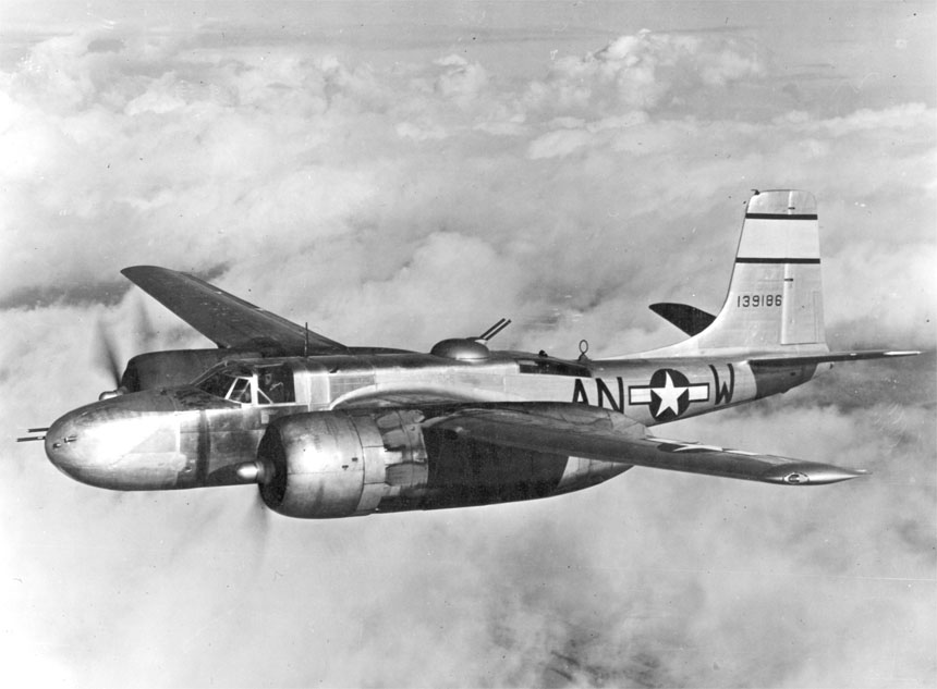
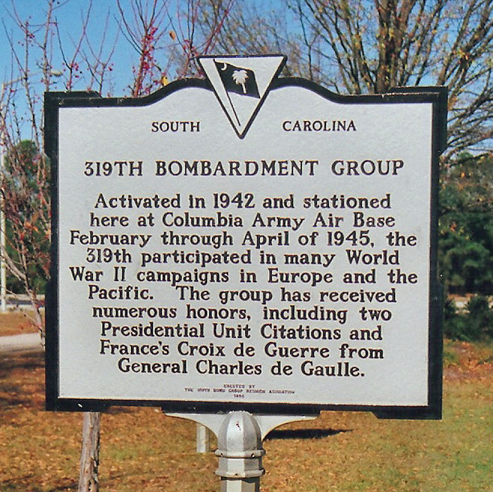
Beginning in 1943, the 309th performed replacement training, rather than group training. On 1 October 1944, Columbia AAB was reassigned to III Bomber Command, and the training units were again redesignated as the Columbia Combat Crew Training Depot (Medium Bombardment). All sub-bases and satellite airfields were either reassigned or inactivated. On 1 February 1945, Columbia was relieved from assignment to Third Air Force, and was transferred to First Air Force. The base unit was redesignated as the 129th Army Air Force Base Unit (Combat Crew Training Station) (Light), and the mission was changed from training B-25 crews to A-26 Invader Light bombardment crews. The 319th Bombardment Group (light) arrived at Columbia on 28 February 1945 from Twelfth Air Force in Italy for conversion training from B-25s to A-26s. The group left for Okinawa on 27 April 1945. Training at Columbia Army Air Base was phased down during the summer of 1945. Several units arrived at the base from overseas to inactivate during September and October. It was inactivated on 30 November and returned to civil authorities, which converted it back to an airport, however, the 350th Bombardment Squadron was assigned to Columbia Metropolitan Airport on 16 July 1947 as part of the Air Force Reserve, but it was never equipped or manned. It was inactivated on 27 June 1949
The current terminal was built in 1965 and renovated in 1997. It replaces a terminal built in the early 1950s which, itself, is a replacement of a terminal built several years earlier in the early 1950s. It has also served as the hub for the abortive low-cost carrier Air South and is currently a hub for United Parcel Service. Since the late 1980s, capital improvements have been undertaken, including a renovated and expanded terminal, a new parking garage (completed in 2003), the lengthening of the runways, and better interstate access. In 2009 Allegiant Airlines offered low cost servie to Orlando-Sanford International Aiprort and Tampa Bay-Saint Petersburg Clearwater International Airport, yet the service did not last. On October,31 2010 US Airways Express operated by Air Wisconsin will begin non-stop service to New York-Laguardia international airport. IncidentsA Volpar E18S (N47A) crashed February 26, 1971 while attempting to land at Columbia Metro. The aircraft crashed during poor visibility and fog while performing a missed approach killing the pilot and 7 passengers. A Beech C90 (N711FC) crashed December 20, 1973 while attempting to land at Columbia Metro. The aircraft collided with trees after descending below minimum descent altitude during poor visibility. The pilot and a passenger were killed and another passenger was seriously injured. A Learjet 60 (N999LJ) attempted to take off from runway 29 of Columbia Owens Field, another airport in Columbia, on September 20, 2008, but crashed into the hillside across a road beyond the end of the runway. Four people died in the crash, the two survivors were musicians Travis Barker and Adam Goldstein. Both suffered major burns, but survived due to the care they received at the Joseph M. Still Burn Center in Augusta, Georgia.. However, Goldstein died less than a year later from an accidental overdose of prescription drugs and cocaine. Features
In popular culture
The above content comes from Wikipedia and is published under free licenses – click here to read more.
Location & QuickFacts
Owner & Manager
Airport Operations and Facilities
Airport Communications
Airport Services
Runway InformationRunway 05/23
Runway 11/29
Helipad H1
Radio Navigation Aids
Remarks
Images and information placed above are from We thank them for the data!
We don't guarantee the information is fresh and accurate. The data may
be wrong or outdated.
|
||||||||||||||||||||||||||||||||||||||||||||||||||||||||||||||||||||||||||||||||||||||||||||||||||||||||||||||||||||||||||||||||||||||||||||||||||||||||||||||||||||||||||||||||||||||||||||||||||||||||||||||||||||||||||||||||||||||||||||||||||||||||||||||||||||||||||||||||||||||||||||||||||||||||||||||||||||||||||||||||||||||||||||||||||||||||||||||||||||||||||||||||||||||||||||||||||||||||||||||||||||||||||||||||||||||||||||||||||||||||||||||||||||||||||||||||||||||||||||||||||||||||||||||||||||||||||||

 |
|
Copyright 2004-2026 © by Airports-Worldwide.com, Vyshenskoho st. 36, Lviv 79010, Ukraine Legal Disclaimer |