 |
|
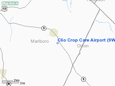
Location & QuickFacts
| FAA Information Effective: | 2008-09-25 |
| Airport Identifier: | 9W9 |
| Airport Status: | Operational |
| Longitude/Latitude: | 079-32-17.1000W/34-33-41.1000N
-79.538083/34.561417 (Estimated) |
| Elevation: | 192 ft / 58.52 m (Estimated) |
| Land: | 38 acres |
| From nearest city: | 2 nautical miles SE of Clio, SC |
| Location: | Marlboro County, SC |
| Magnetic Variation: | 06W (1985) |
Owner & Manager
| Ownership: | Privately owned |
| Owner: | Ken Hanke |
| Address: | Po Box 422
Clio, SC 29525 |
| Phone number: | 803-586-9225 |
| Manager: | Ken Hanke |
| Address: | Po Box 422
Clio, SC 29525 |
| Phone number: | 843-586-9225 |
Airport Operations and Facilities
| Airport Use: | Open to public |
| Wind indicator: | Yes |
| Segmented Circle: | No |
| Control Tower: | No |
| Landing fee charge: | No |
| Sectional chart: | Charlotte |
| Region: | ASO - Southern |
| Traffic Pattern Alt: | 600 ft |
| Boundary ARTCC: | ZJX - Jacksonville |
| Tie-in FSS: | AND - Anderson |
| FSS on Airport: | No |
| FSS Toll Free: | 1-800-WX-BRIEF |
| NOTAMs Facility: | AND (NOTAM-d service avaliable) |
Airport Communications
Airport Services
| Airframe Repair: | NONE |
| Power Plant Repair: | NONE |
| Bottled Oxygen: | NONE |
| Bulk Oxygen: | NONE |
Runway Information
Runway 05/23
| Dimension: | 2598 x 125 ft / 791.9 x 38.1 m |
| Surface: | TURF, Good Condition |
| |
Runway 05 |
Runway 23 |
| Longitude: | 079-32-27.9296W | 079-32-06.2804W |
| Latitude: | 34-33-31.9171N | 34-33-50.3477N |
| Elevation: | 192.00 ft | 192.00 ft |
| Traffic Pattern: | Left | Left |
| Obstruction: | 60 ft tree, 200.0 ft from runway, 80 ft right of centerline, 3:1 slope to clear | 65 ft tree, 685.0 ft from runway, 50 ft right of centerline, 10:1 slope to clear |
|
Radio Navigation Aids
| ID |
Type |
Name |
Ch |
Freq |
Var |
Dist |
| BES | NDB | Bennettsville | | 230.00 | 07W | 10.3 nm |
| DLC | NDB | Dillon | | 274.00 | 05W | 10.7 nm |
| ME | NDB | Maxtn | | 257.00 | 08W | 11.4 nm |
| UDG | NDB | Darlington | | 245.00 | 06W | 18.7 nm |
| RCZ | NDB | Roscoe | | 375.00 | 07W | 19.1 nm |
| CQW | NDB | Cheraw | | 409.00 | 05W | 19.5 nm |
| JB | NDB | Jigel | | 384.00 | 08W | 19.8 nm |
| RSY | NDB | Robeson | | 359.00 | 08W | 23.9 nm |
| MAO | NDB | Marion | | 388.00 | 06W | 24.8 nm |
| HFF | NDB | Mackall | | 278.00 | 06W | 28.2 nm |
| HVS | NDB | Hartsville | | 341.00 | 07W | 30.3 nm |
| AFP | NDB | Anson County | | 283.00 | 07W | 38.7 nm |
| PYG | NDB | Pageland | | 270.00 | 06W | 41.1 nm |
| CFY | NDB | Evans | | 420.00 | 06W | 43.9 nm |
| CPC | NDB | Camp | | 227.00 | 07W | 44.4 nm |
| HYW | NDB | Horry | | 370.00 | 08W | 48.8 nm |
| POB | NDB | Pope | | 338.00 | 07W | 49.3 nm |
| FGP | NDB | Fort Bragg | | 393.00 | 07W | 49.9 nm |
| POB | TACAN | Pope | 085X | | 07W | 44.1 nm |
| LBT | VOR | Lumberton | | 110.00 | 08W | 24.1 nm |
| CTF | VOR/DME | Chesterfield | 019X | 108.20 | 03W | 36.8 nm |
| FAY | VOR/DME | Fayetteville | 025X | 108.80 | 04W | 41.5 nm |
| FLO | VORTAC | Florence | 099X | 115.20 | 03W | 20.6 nm |
| SDZ | VORTAC | Sandhills | 055X | 111.80 | 03W | 39.4 nm |
Remarks
- RY 23 100 FT R OF CNTRLN HGR & OFFICE AREA & TANKS 100 FT L 0 FT FM THLD & CONCRETE BLDG 125 FT R 0-100 FT FM THLD.
- VFR USE ONLY.
Images and information placed above are from
http://www.airport-data.com/airport/9W9/
We thank them for the data!
| General Info
|
| Country |
United States
|
| State |
SOUTH CAROLINA
|
| FAA ID |
9W9
|
| Latitude |
34-33-41.100N
|
| Longitude |
079-32-17.100W
|
| Elevation |
192 feet
|
| Near City |
CLIO
|
We don't guarantee the information is fresh and accurate. The data may
be wrong or outdated.
For more up-to-date information please refer to other sources.
|
|


