 |
|
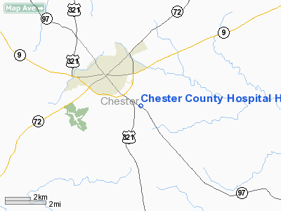
Chester County Hospital Heliport |
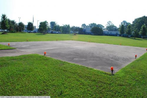 |
(Click on the photo to enlarge) |
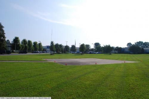 |
(Click on the photo to enlarge) |
Location & QuickFacts
| FAA Information Effective: | 2008-09-25 |
| Airport Identifier: | SC85 |
| Airport Status: | Operational |
| Longitude/Latitude: | 081-11-02.3180W/34-41-00.5030N
-81.183977/34.683473 (Estimated) |
| Elevation: | 700 ft / 213.36 m (Estimated) |
| Land: | 0 acres |
| From nearest city: | 0 nautical miles N of Chester, SC |
| Location: | Chester County, SC |
| Magnetic Variation: | 05W (1990) |
Owner & Manager
| Ownership: | Privately owned |
| Owner: | Chester County Hospital & Nur |
| Address: | Great Falls Road
Chester, SC 29706 |
| Phone number: | 803-581-9411 |
| Manager: | William Lee Midkiff |
| Address: | Great Falls Road
Chester, SC 29706 |
| Phone number: | 803-581-9411 |
Airport Operations and Facilities
| Airport Use: | Private
MEDICAL USE. |
| Wind indicator: | Yes |
| Segmented Circle: | No |
| Control Tower: | No |
| Sectional chart: | Atlanta |
| Region: | ASO - Southern |
| Boundary ARTCC: | ZTL - Atlanta |
| Tie-in FSS: | AND - Anderson |
| FSS Toll Free: | 1-800-WX-BRIEF |
Runway Information
Helipad H1
| Dimension: | 60 x 60 ft / 18.3 x 18.3 m |
| Surface: | TURF, |
| |
Runway H1 |
Runway |
| Traffic Pattern: | Left | Left |
|
Radio Navigation Aids
| ID |
Type |
Name |
Ch |
Freq |
Var |
Dist |
| DCM | NDB | Chester | | 220.00 | 06W | 6.3 nm |
| UZ | NDB | Rally | | 227.00 | 05W | 13.4 nm |
| LKR | NDB | Lancaster | | 400.00 | 07W | 16.3 nm |
| FDW | NDB | Winnsboro | | 414.00 | 05W | 22.5 nm |
| UOT | NDB | Union County | | 326.00 | 04W | 22.7 nm |
| TWL | NDB | Wesley | | 204.00 | 06W | 28.6 nm |
| GHJ | NDB | Stonia | | 260.00 | 06W | 30.5 nm |
| EOE | NDB | Enoree | | 278.00 | 05W | 31.6 nm |
| CDN | NDB | Camden | | 263.00 | 05W | 39.1 nm |
| LUX | NDB | Laurens | | 307.00 | 04W | 39.3 nm |
| SLP | NDB | First River | | 417.00 | 06W | 39.9 nm |
| FRT | NDB | Fairmont | | 248.00 | 05W | 41.7 nm |
| PYG | NDB | Pageland | | 270.00 | 06W | 42.0 nm |
| MMT | NDB | Mc Entire | | 427.00 | 05W | 48.8 nm |
| CLT | VOR/DME | Charlotte | 097X | 115.00 | 05W | 32.5 nm |
| CTF | VOR/DME | Chesterfield | 019X | 108.20 | 03W | 45.0 nm |
| FML | VORTAC | Fort Mill | 071X | 112.40 | 02W | 21.6 nm |
| SPA | VORTAC | Spartanburg | 104X | 115.70 | 02W | 42.3 nm |
| MMT | VORTAC | Mc Entire | 079X | 113.20 | 05W | 49.4 nm |
| CLT | VOT | Charlotte | | 112.00 | | 34.2 nm |
Remarks
Images and information placed above are from
http://www.airport-data.com/airport/SC85/
We thank them for the data!
| General Info
|
| Country |
United States
|
| State |
SOUTH CAROLINA
|
| FAA ID |
SC85
|
| Latitude |
34-41-00.503N
|
| Longitude |
081-11-02.318W
|
| Elevation |
700 feet
|
| Near City |
CHESTER
|
We don't guarantee the information is fresh and accurate. The data may
be wrong or outdated.
For more up-to-date information please refer to other sources.
|
|


